Cayo Chacmochuk
Welcome to Cayo Chacmochuk, a Tropical island in the Caribbean Sea, part of the majestic Atlantic Ocean. This guide offers a comprehensive overview of what makes Cayo Chacmochuk unique – from its geography and climate to its population, infrastructure, and beyond. Dive into the details:
- Geography and Size: Explore the island’s size and location.
- Climate and Weather: Weather patterns and temperature.
- Topography and Nature: Uncover the natural wonders of the island.
- Infrastructure and Travelling: Insights on reaching, staying, and making the most of your visit.
- News and Headlines: Latest News.
Geography and size of Cayo Chacmochuk
Size: 1.433 km²
Coastline: 9.5 km
Ocean: Atlantic Ocean
Sea: Caribbean Sea
Continent: North America
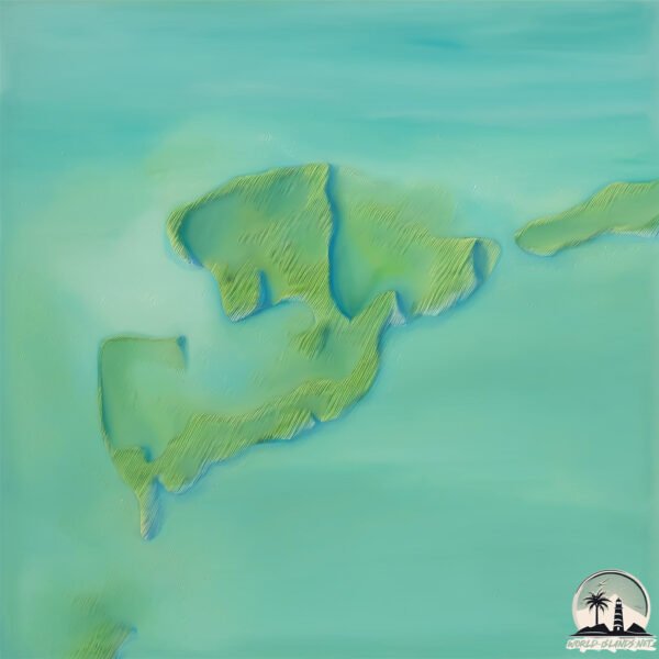
Cayo Chacmochuk is a Small Island spanning 1.4 km² with a coastline of 9.5 km.
Archipel: –
Tectonic Plate: North America – Covers North America and parts of the Atlantic and Arctic Oceans, characterized by diverse geological features and varying levels of seismic activity.
The geographic heart of the island is pinpointed at these coordinates:
Latitude: 21.42783041 / Longitude: -86.88011427
Climate and weather of Cayo Chacmochuk
Climate Zone: Tropical
Climate Details: Tropical Savanna, Wet
Temperature: Hot
Climate Characteristics: Defined by distinct wet and dry seasons with high temperatures year-round. Pronounced rainfall occurs during the wet season, while the dry season is marked by drought.
Topography and nature of Cayo Chacmochuk
Timezone: UTC-06:00
Timezone places: America/Chicago
Max. Elevation: -3 m
Mean Elevation: -24 m
Vegetation: Cultivated Land
Tree Coverage: 71%
The mean elevation is -24 m. Remarkably, this unique island barely emerges above the sea level, showcasing nature’s fascinating interplay with the ocean. The island is characterized by Plains: Flat, low-lying lands characterized by a maximum elevation of up to 200 meters. On islands, plains are typically coastal lowlands or central flat areas.
Dominating Vegetation: Cultivated Land
Areas dedicated to agricultural activities, growing crops like grains, vegetables, and fruits. These lands are usually human-modified landscapes. Cayo Chacmochuk has a tree cover of 71 %.
Vegetation: 2 vegetation zones – Low Diversity Island
Islands with two distinct vegetation zones offer slightly more ecological variety. These zones could be due to differences in elevation, moisture, or other environmental factors. While still limited in biodiversity, these islands may offer a contrast between the two zones, such as a coastline with mangroves and an inland area with grassland.
Infrastructure and Travelling to Cayo Chacmochuk
Does the island have a public airport? no.
There is no public and scheduled airport on Cayo Chacmochuk. The nearest airport is Aeropuerto Internacional de Cancún, located 42 km away.
Does the island have a major port? no.
There are no major ports on Cayo Chacmochuk. The closest major port is SAN MIGUEL DE COZUMEL, approximately 102 km away.
The mean population of Cayo Chacmochuk is 14 per km². Cayo Chacmochuk is Gently Populated. The island belongs to Mexico.
Continuing your journey, de Holbox is the next notable island, situated merely km away.
COSAS IMPERDIBLES EN ISLA HOLBOX


Mexico is classified as Emerging region: MIKT: Mexico, Indonesia, South Korea, and Turkey – Economies recognized for their development potential and emerging market status. The level of income is Upper middle income.
News – Latest Updates and Headlines from Cayo Chacmochuk
Stay informed with the most recent news and important headlines from Cayo Chacmochuk. Here’s a roundup of the latest developments.
Please note: The data used here has been primarily extracted from satellite readings. Deviations from exact values may occur, particularly regarding the height of elevations and population density. Land area and coastline measurements refer to average values at mean high tide.