Cayo de los Indios
Welcome to Cayo de los Indios, a Tropical island in the Caribbean Sea, part of the majestic Atlantic Ocean. This guide offers a comprehensive overview of what makes Cayo de los Indios unique – from its geography and climate to its population, infrastructure, and beyond. Dive into the details:
- Geography and Size: Explore the island’s size and location.
- Climate and Weather: Weather patterns and temperature.
- Topography and Nature: Uncover the natural wonders of the island.
- Infrastructure and Travelling: Insights on reaching, staying, and making the most of your visit.
- News and Headlines: Latest News.
Geography and size of Cayo de los Indios
Size: 4.545 km²
Coastline: 17.5 km
Ocean: Atlantic Ocean
Sea: Caribbean Sea
Continent: North America
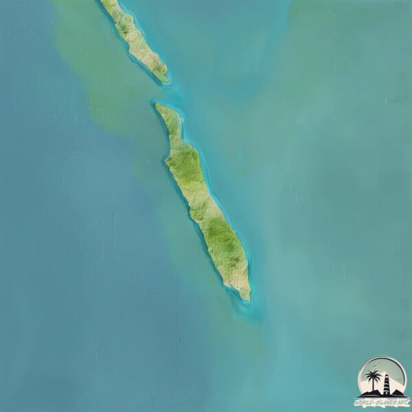
Cayo de los Indios is a Small Island spanning 4.5 km² with a coastline of 17.5 km.
Archipel: Greater Antilles – A major island group in the Caribbean, including Cuba, Jamaica, Hispaniola, and Puerto Rico, known for their rich history and diverse cultures.
Tectonic Plate: North America – Covers North America and parts of the Atlantic and Arctic Oceans, characterized by diverse geological features and varying levels of seismic activity.
The geographic heart of the island is pinpointed at these coordinates:
Latitude: 21.795951 / Longitude: -83.19346387
Climate and weather of Cayo de los Indios
Climate Zone: Tropical
Climate Details: Tropical Savanna, Wet
Temperature: Hot
Climate Characteristics: Defined by distinct wet and dry seasons with high temperatures year-round. Pronounced rainfall occurs during the wet season, while the dry season is marked by drought.
Topography and nature of Cayo de los Indios
Timezone: UTC-05:00
Timezone places: America/New_York
Max. Elevation: 6 m
Mean Elevation: 5 m
Vegetation: Mangrove Forest
Tree Coverage: 66%
The mean elevation is 5 m. The highest elevation on the island reaches approximately 6 meters above sea level. The island is characterized by Plains: Flat, low-lying lands characterized by a maximum elevation of up to 200 meters. On islands, plains are typically coastal lowlands or central flat areas.
Dominating Vegetation: Mangrove Forest
Found in coastal areas and river deltas, these unique wetland ecosystems are adapted to saline conditions and are crucial for coastal protection and biodiversity. Cayo de los Indios has a tree cover of 66 %.
Vegetation: 4 vegetation zones – Diverse Island
Four distinct vegetation zones mark these islands as ecologically diverse. They might feature varied landscapes such as forests, beaches, grasslands, and rocky areas. Such diversity reflects the island’s complex ecological interactions and varied habitats, which can support a rich array of wildlife and plant species.
Infrastructure and Travelling to Cayo de los Indios
Does the island have a public airport? no.
There is no public and scheduled airport on Cayo de los Indios. The nearest airport is Rafael Cabrera Airport, located 45 km away.
Does the island have a major port? no.
There are no major ports on Cayo de los Indios. The closest major port is NUEVA GERONA, approximately 45 km away.
The mean population of Cayo de los Indios is 34 per km². Cayo de los Indios is Gently Populated. The island belongs to Cuba.
Continuing your journey, Juventud is the next notable island, situated merely km away.
Cayo Santiago, la isla-laboratorio de Puerto Rico habitada solo por monos


Cuba is classified as Emerging region: G20: Group of Twenty – Major economies comprising both developed and emerging countries, representing the world’s largest economies. The level of income is Upper middle income.
News – Latest Updates and Headlines from Cayo de los Indios
Stay informed with the most recent news and important headlines from Cayo de los Indios. Here’s a roundup of the latest developments.
Please note: The data used here has been primarily extracted from satellite readings. Deviations from exact values may occur, particularly regarding the height of elevations and population density. Land area and coastline measurements refer to average values at mean high tide.