Cayos Miskitos
Welcome to Cayos Miskitos, a Tropical island in the Caribbean Sea, part of the majestic Atlantic Ocean. This guide offers a comprehensive overview of what makes Cayos Miskitos unique – from its geography and climate to its population, infrastructure, and beyond. Dive into the details:
- Geography and Size: Explore the island’s size and location.
- Climate and Weather: Weather patterns and temperature.
- Topography and Nature: Uncover the natural wonders of the island.
- Infrastructure and Travelling: Insights on reaching, staying, and making the most of your visit.
- News and Headlines: Latest News.
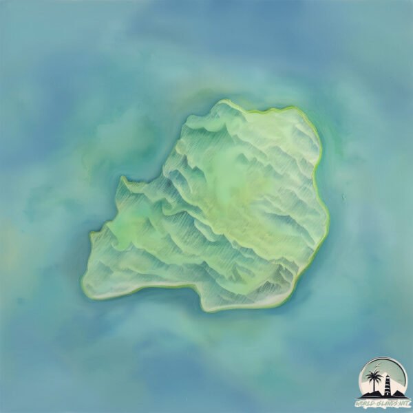
Geography and size of Cayos Miskitos
Size: 39 km²
Coastline: 47.7 km
Ocean: Atlantic Ocean
Sea: Caribbean Sea
Continent: North America
Cayos Miskitos is a Medium Island spanning 39 km² with a coastline of 48 km.
Archipel: –
Tectonic Plate: Caribbean – Covering the Caribbean Sea and surrounding regions, this plate is bordered by the North American Plate and the South American Plate. Known for seismic activity, including earthquakes and volcanic eruptions, and features like the Puerto Rico Trench.
The geographic heart of the island is pinpointed at these coordinates:
Latitude: 14.38264568 / Longitude: -82.76729252
Climate and weather of Cayos Miskitos
Climate Zone: Tropical
Climate Details: Tropical Monsoon Climate
Temperature: Hot
Climate Characteristics: Characterized by heavy rainfall, high humidity, and uniformly high temperatures, but with a distinct short dry season. It features a seasonal reversal of prevailing wind directions.
Topography and nature of Cayos Miskitos
Timezone: UTC-06:00
Timezone places: America/Chicago
Max. Elevation: 13 m
Mean Elevation: 7 m
Vegetation: Mangrove Forest
Tree Coverage: 44%
The mean elevation is 7 m. The highest elevation on the island reaches approximately 13 meters above sea level. The island is characterized by Plains: Flat, low-lying lands characterized by a maximum elevation of up to 200 meters. On islands, plains are typically coastal lowlands or central flat areas.
Dominating Vegetation: Mangrove Forest
Found in coastal areas and river deltas, these unique wetland ecosystems are adapted to saline conditions and are crucial for coastal protection and biodiversity. Cayos Miskitos has a tree cover of 44 %.
Vegetation: 11 vegetation zones – Exceptionally Diverse Island
Islands with more than ten vegetation zones are among the most ecologically rich and varied in the world. These islands are akin to miniature continents, boasting an incredible array of ecosystems. The sheer range of habitats, from high peaks to deep valleys, rainforests to deserts, creates a mosaic of life that is unparalleled. They are crucial for conservation and ecological studies.
Infrastructure and Travelling to Cayos Miskitos
Does the island have a public airport? no.
There is no public and scheduled airport on Cayos Miskitos. The nearest airport is Puerto Cabezas Airport, located 72 km away.
Does the island have a major port? no.
There are no major ports on Cayos Miskitos. The closest major port is PUERTO CABEZAS, approximately 73 km away.
The mean population of Cayos Miskitos is 24 per km². Cayos Miskitos is Gently Populated. The island belongs to Nicaragua.
Continuing your journey, Sumpiki Dakura is the next notable island, situated merely km away.
Cayos Miskitos, Caribe Norte


Nicaragua is classified as Developing region: Regions characterized by lower income levels, with economies in the process of industrialization and modernization. The level of income is Lower middle income.
News – Latest Updates and Headlines from Cayos Miskitos
Stay informed with the most recent news and important headlines from Cayos Miskitos. Here’s a roundup of the latest developments.
Please note: The data used here has been primarily extracted from satellite readings. Deviations from exact values may occur, particularly regarding the height of elevations and population density. Land area and coastline measurements refer to average values at mean high tide.