Welcome to Ceann Iar, a Temperate island in the North Atlantic Ocean, part of the majestic Atlantic Ocean. This guide offers a comprehensive overview of what makes Ceann Iar unique – from its geography and climate to its population, infrastructure, and beyond. Dive into the details:
Geography and size of Ceann Iar
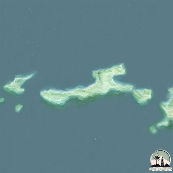
Size: 1.888 km²
Coastline: 11.3 km
Ocean: Atlantic Ocean
Sea: North Atlantic Ocean
Continent: Europe
Ceann Iar is a Small Island spanning 1.9 km² with a coastline of 11.3 km.
Archipel: Outer Hebrides – A chain of islands off the west coast of mainland Scotland, known for their rugged beauty, Gaelic culture, and traditional way of life.
Tectonic Plate: Eurasia – One of the world’s largest tectonic plates, the Eurasian Plate covers a significant portion of Europe and Asia. It’s characterized by diverse geological features, including the Ural Mountains, the European Plain, and the Himalayas formed from its collision with the Indian Plate.
The geographic heart of the island is pinpointed at these coordinates:
Latitude: 57.52600139 / Longitude: -7.65894173
Climate and weather of Ceann Iar
Climate Zone: Temperate
Climate Details: Temperate Oceanic Climate
Temperature: Warm Summer
Climate Characteristics: Known for its moderate year-round temperatures with ample rainfall and no dry season. Warm summers are characteristic.
Topography and nature of Ceann Iar
Timezone: UTC±00:00
Timezone places: Europe/London
Max. Elevation: 4 m
Mean Elevation: -6 m
Vegetation: Agricultural Mosaic
Tree Coverage: 24%
The mean elevation is -6 m. The highest elevation on the island reaches approximately 4 meters above sea level. The island is characterized by Plains: Flat, low-lying lands characterized by a maximum elevation of up to 200 meters. On islands, plains are typically coastal lowlands or central flat areas.
Dominating Vegetation: Agricultural Mosaic
A mix of cropland and natural vegetation, often seen in rural landscapes where agricultural fields are interspersed with patches of natural habitats. Ceann Iar has a tree cover of 24 %.
Vegetation: 5 vegetation zones – Highly Diverse Island
With five different vegetation zones, these islands offer a rich tapestry of ecosystems. The variety could include dense forests, open meadows, wetlands, coastal zones, and more. This level of diversity supports an intricate web of life, with each zone playing a vital role in the overall ecological health and balance of the island.
Infrastructure and Travelling to Ceann Iar
Does the island have a public airport? no.
There is no public and scheduled airport on Ceann Iar. The nearest airport is Benbecula Airport, located 31 km away.
Does the island have a major port? no.
There are no major ports on Ceann Iar. The closest major port is LOCHMADDY, approximately 53 km away.
The mean population of Ceann Iar is 3 per km². Ceann Iar is Gently Populated. The island belongs to United Kingdom.
Continuing your journey, Baleshare is the next notable island, situated merely km away.
00373 Bill wading at ford from Shivinish to Ceann Iar
00373 Bill wading at ford from Shivinish to Ceann Iar
【无线超越班第一季】EP10FULL:《倩女幽魂》居然杀回来了!谁最配演经典港片男女主?#搞笑 #遊戲 #港劇 #优酷综艺
【闲趣研究所】 笑点密集·热综云集|《麻花特开心第二季》爆笑回归| 每日更新治愈你的不开心!
【闲趣研究所】 笑点密集·热综云集|《麻花特开心第二季》爆笑回归| 每日更新治愈你的不开心!
The 10 Must-Visit Spots in the Canary Islands
Explore the enchanting beauty of the Canary Islands with our guide to ...
Explore the enchanting beauty of the Canary Islands with our guide to the 10 Must-Visit Spots. From the stunning beaches of ...
Best Islands To Retire Comfortably
"Discover the 'Top 10 Best Islands to Retire On Comfortably in the ...
"Discover the 'Top 10 Best Islands to Retire On Comfortably in the World' in our latest feature, perfectly tailored for those seeking ...
Ceann Sibeal Hotel
Ceann Sibeal Hotel 2017.
Ceann Sibeal Hotel 2017.
24 Hours In Scotland’s Northernmost City
Use code ruthaisling at the link below to get an exclusive 60% off an ...
Ceann An Sàs 🍲😲 | OMC! | BBC ALBA
Comadaidh às ùr le sgeidsichean loma-làn charactaran èibhinn, ...
Comadaidh às ùr le sgeidsichean loma-làn charactaran èibhinn, sgeulachdan gaoil agus cùisean eagail. Air a sgrìobhadh le cuid ...
Where Nature Broke the Rules: The 8 Realms of Wild Australia
Wild Australia is a journey into one of the most isolated and extreme ...
Wild Australia is a journey into one of the most isolated and extreme natural worlds on Earth. From ancient rainforests that predate ...
Top 10 Affordable All-Inclusive Resorts in the World
Let's explore the Top 10 Affordable All-Inclusive Resorts in the ...
Let's explore the Top 10 Affordable All-Inclusive Resorts in the World, Whether you are planning a family holiday or an adults-only ...
Ceann Sibéal Kerry Aerial Photography
This video was shot with a Phantom 4 quadcopter, If you would like to ...
This video was shot with a Phantom 4 quadcopter, If you would like to use any footage of mine please contact ...
EPSTEIN ADASI'NA GİTTİM - EPSTEIN DOSYALARI
Epstein Adası'nın Karanlık Sırları: Oraya Gittim! Jeffrey Epstein ...
Epstein Adası'nın Karanlık Sırları: Oraya Gittim! Jeffrey Epstein kimdir ve dünyayı sarsan bu karanlık ağ nasıl kuruldu? Bill Clinton ...
Amanpulo, World's Best Beach Resort in Palawan Philippines, Aman Hotel (4K Tour & Vlog)
This is a review of the Amanpulo, the world's best 5-star luxury beach ...
This is a review of the Amanpulo, the world's best 5-star luxury beach resort. Amanpulo is located on Pamalican Island in the ...
Mexico's Top 10 Best Islands
Discover Mexico's Top 10 Best Islands: Journey through the sun-soaked ...
Discover Mexico's Top 10 Best Islands: Journey through the sun-soaked coasts of Mexico with our expert guide to "Mexico's Top ...
Cauayan Island Resort El Nido, Palawan, Philippines - 5 Star Hotel (4K Travel Vlog)
Let's take a look at luxury travel in El Nido, Palawan, Philippines, ...
Let's take a look at luxury travel in El Nido, Palawan, Philippines, including the 5-star hotel Cauayan Island Resort and island ...
Why Did the VATICAN BAN This BOOK?
Why Did the VATICAN BANNED This BOOK? The Gospel of Barnabas is one of ...
Why Did the VATICAN BANNED This BOOK? The Gospel of Barnabas is one of the most controversial and mysterious books in ...
【キャンピングカーの旅】しまなみ海道満喫
【キャンピングカーの旅】しまなみ海道満喫 しまなみ海道のグルメと名所を満喫する旅 短期間ですが瀬戸内の魅力を感じる事が ...
【キャンピングカーの旅】しまなみ海道満喫 しまなみ海道のグルメと名所を満喫する旅 短期間ですが瀬戸内の魅力を感じる事が ...
10 Best Caribbean Islands for Living or Retiring
Discover the allure of the Caribbean with our curated list of the 10 ...
Discover the allure of the Caribbean with our curated list of the 10 best Caribbean islands for living or retiring. Each island boasts ...
Maighdeannan Na H-Àiridh
Provided to YouTube by CDBaby Maighdeannan Na H-Àiridh · Ceann An ...
Provided to YouTube by CDBaby Maighdeannan Na H-Àiridh · Ceann An Tuirc Deich Bliadhna: Ten Years of Còisir Ceann An ...
The Untold Story Of The Widow Who Battled Demons For Survival
Could rebuilding your life cause destruction? Could it stir up an old ...
Could rebuilding your life cause destruction? Could it stir up an old evil? When a family loses their father in a blaze. The widow ...
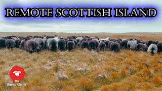
THE WILD SHEEP OF THE MONACH ISLES | Farming in the Outer Hebrides of Scotland
Visit the uninhabited outlying islands of the Monach Isles (Heisker) ...
Visit the uninhabited outlying islands of the Monach Isles (Heisker) which is a National Nature Reserve and lies off the west coast ...
Sicily's Top 7 Best Places To Visit
Experience the captivating allure of Sicily as you delve into its top ...
Experience the captivating allure of Sicily as you delve into its top 7 destinations. This sun-soaked Italian island is more than just ...
【麻花特开心 第二季】EP06下:高能预警!常远为救沈腾街头肉搏,全员街巷混战太上头!#杨幂#赵丽颖#宋小宝#沈腾#马丽
《麻花特开心》第二季是由开心麻花团队打造的原创喜剧真人秀节目。节目由沈腾、马丽携手艾伦、常远等开心麻花成员共同参与, ...
《麻花特开心》第二季是由开心麻花团队打造的原创喜剧真人秀节目。节目由沈腾、马丽携手艾伦、常远等开心麻花成员共同参与, ...
Monach Lighthouse
Monach lighthouse, Shillay.
Monach lighthouse, Shillay.
Top 10 Places In Crete The Ultimate Traveler's Guide
Exclusive Tips & Top Deals! Join the newsletter now ...
Exclusive Tips & Top Deals! Join the newsletter now traveldroner.com/newsletter Explore the Top 10 Places In Crete with this ...
MSC World America Cruise Ship 2025 | Sailing from Miami to Ocean Cay Island Bahamas (4K Tour & Vlog)
Today we will take a look at the 3-night celebratory sailing of MSC ...
Today we will take a look at the 3-night celebratory sailing of MSC Cruises' newest and largest cruise ship, MSC World America, ...
United Kingdom is classified as Developed region: G7: Group of Seven – Major advanced economies, including Canada, France, Germany, Italy, Japan, the United Kingdom, and the United States. The level of income is High income: OECD.
News – Latest Updates and Headlines from Ceann Iar
Stay informed with the most recent news and important headlines from Ceann Iar. Here’s a roundup of the latest developments.
Loading...
Please note: The data used here has been primarily extracted from satellite readings. Deviations from exact values may occur, particularly regarding the height of elevations and population density. Land area and coastline measurements refer to average values at mean high tide.