Cedros
Welcome to Cedros, a Dry island in the North Pacific Ocean, part of the majestic Pacific Ocean. This guide offers a comprehensive overview of what makes Cedros unique – from its geography and climate to its population, infrastructure, and beyond. Dive into the details:
- Geography and Size: Explore the island’s size and location.
- Climate and Weather: Weather patterns and temperature.
- Topography and Nature: Uncover the natural wonders of the island.
- Infrastructure and Travelling: Insights on reaching, staying, and making the most of your visit.
- News and Headlines: Latest News.
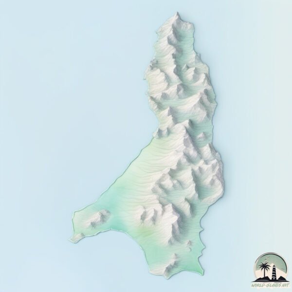
Geography and size of Cedros
Size: 350.4 km²
Coastline: 143 km
Ocean: Pacific Ocean
Sea: North Pacific Ocean
Continent: North America
Cedros is a Large Island spanning 350 km² with a coastline of 143 km.
Archipel: –
Tectonic Plate: Pacific – The world’s largest tectonic plate, covering much of the Pacific Ocean, known for the Pacific Ring of Fire with extensive seismic and volcanic activity.
The geographic heart of the island is pinpointed at these coordinates:
Latitude: 28.18008587 / Longitude: -115.23022913
Climate and weather of Cedros
Climate Zone: Dry
Climate Details: Cold Desert Climate
Temperature: Cold
Climate Characteristics: Similar in dryness to hot deserts but with cold winters. Days can be warm or hot, while nights are typically chilly with common frost occurrences.
Topography and nature of Cedros
Timezone: UTC-07:00
Timezone places: America/Denver
Max. Elevation: 1074 m
Mean Elevation: 286 m
Vegetation: Shrubland
Tree Coverage: 8%
The mean elevation is 286 m. The highest elevation on the island reaches approximately 1074 meters above sea level. The island is characterized by Plateau: Elevated flatlands rising sharply above the surrounding area, with a maximum elevation over 500 meters but a mean elevation less than 300 meters, forming unique highland areas on islands.
Dominating Vegetation: Shrubland
Dominated by shrubs and small bushes, these areas are typical in dry, rocky, or sandy environments, as well as in regions with poor soil fertility. Cedros has a tree cover of 8 %.
Vegetation: 10 vegetation zones – Very Highly Diverse Island
Islands in this range are ecological powerhouses, showcasing a wide array of vegetation zones. Each zone, from lush rainforests to arid scrublands, coastal mangroves to mountainous regions, contributes to a complex and interdependent ecosystem. These islands are often hotspots of biodiversity, supporting numerous species and intricate ecological processes.
Infrastructure and Travelling to Cedros
Does the island have a public airport? no.
There is no public and scheduled airport on Cedros. The nearest airport is Guerrero Negro Airport, located 127 km away.
Does the island have a major port? yes.
Cedros is home to a major port. The following ports are situated on the island: .
The mean population of Cedros is 7 per km². Cedros is Gently Populated. The island belongs to Mexico.
Continuing your journey, Angel de la Guarda is the next notable island, situated merely km away.
Cedros Island Tackle Tips - What gear to bring to Cedros


Mexico is classified as Emerging region: MIKT: Mexico, Indonesia, South Korea, and Turkey – Economies recognized for their development potential and emerging market status. The level of income is Upper middle income.
News – Latest Updates and Headlines from Cedros
Stay informed with the most recent news and important headlines from Cedros. Here’s a roundup of the latest developments.
Please note: The data used here has been primarily extracted from satellite readings. Deviations from exact values may occur, particularly regarding the height of elevations and population density. Land area and coastline measurements refer to average values at mean high tide.