Chaloupe
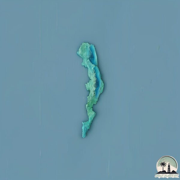
Welcome to Chaloupe, a Tropical island in the Indian Ocean, part of the majestic Indian Ocean. This guide offers a comprehensive overview of what makes Chaloupe unique – from its geography and climate to its population, infrastructure, and beyond. Dive into the details:
- Geography and Size: Explore the island’s size and location.
- Climate and Weather: Weather patterns and temperature.
- Topography and Nature: Uncover the natural wonders of the island.
- Infrastructure and Travelling: Insights on reaching, staying, and making the most of your visit.
- News and Headlines: Latest News.
Geography and size of Chaloupe
Size: 2.031 km²
Coastline: 14.5 km
Ocean: Indian Ocean
Sea: Indian Ocean
Continent: Seven seas (open ocean)
Chaloupe is a Small Island spanning 2 km² with a coastline of 14.5 km.
Archipel: –
Tectonic Plate: Australia – A major tectonic plate covering Australia, New Zealand, and parts of the Indian and Pacific Oceans, known for its relative stability and occasional seismic activity.
The geographic heart of the island is pinpointed at these coordinates:
Latitude: -16.75003552 / Longitude: 59.57052892
Climate and weather of Chaloupe
Climate Zone: Tropical
Climate Details: Tropical Savanna, Wet
Temperature: Hot
Climate Characteristics: Defined by distinct wet and dry seasons with high temperatures year-round. Pronounced rainfall occurs during the wet season, while the dry season is marked by drought.
Topography and nature of Chaloupe
Timezone: UTC+04:00
Timezone places: Asia/Dubai
Max. Elevation: 2 m
Mean Elevation: 2 m
Vegetation: Sparse Vegetation with Trees/Shrubs
Tree Coverage: 79%
The mean elevation is 2 m. The highest elevation on the island reaches approximately 2 meters above sea level. The island is characterized by Plains: Flat, low-lying lands characterized by a maximum elevation of up to 200 meters. On islands, plains are typically coastal lowlands or central flat areas.
Dominating Vegetation: Sparse Vegetation with Trees/Shrubs
Areas where grasses and other herbaceous plants are prevalent, but with occasional presence of trees and shrubs. Often found in semi-arid regions or grasslands. Chaloupe has a tree cover of 79 %.
Vegetation: 1 vegetation zones – Minimal Diversity Island
These islands exhibit the most basic level of ecological diversity, often characterized by a single dominant vegetation type. This could be due to extreme environmental conditions, limited land area, or significant human impact. They represent unique ecosystems where specific species have adapted to thrive in these singular environments.
Infrastructure and Travelling to Chaloupe
Does the island have a public airport? no.
There is no public and scheduled airport on Chaloupe. The nearest airport is Sir Seewoosagur Ramgoolam International Airport, located 457 km away.
Does the island have a major port? no.
There are no major ports on Chaloupe. The closest major port is PORT LOUIS, approximately 440 km away.
The mean population of Chaloupe is 0 per km². Chaloupe is Uninhabited. The island belongs to Mauritius.
Continuing your journey, Mauritius is the next notable island, situated merely km away.
Webcam Noirmoutier - La Chaloupe


Mauritius is classified as Developing region: Regions characterized by lower income levels, with economies in the process of industrialization and modernization. The level of income is Upper middle income.
News – Latest Updates and Headlines from Chaloupe
Stay informed with the most recent news and important headlines from Chaloupe. Here’s a roundup of the latest developments.
- UK court refuses permission for case over UK-Mauritius deal on Chagos Islands - CNBC Africaby "Mauritius island" - Google News on 10 March 2026
UK court refuses permission for case over UK-Mauritius deal on Chagos Islands CNBC Africa
- UK Court Blocks Challenge Over Sovereignty Deal on Chagos Islands - Global Banking & Finance Review®by "Mauritius island" - Google News on 10 March 2026
UK Court Blocks Challenge Over Sovereignty Deal on Chagos Islands Global Banking & Finance Review®
- UK court refuses permission for case over UK-Mauritius deal on Chagos Islands - Reutersby "Mauritius island" - Google News on 10 March 2026
UK court refuses permission for case over UK-Mauritius deal on Chagos Islands Reuters
- Mauritius: How to explore the island paradise beyond the beach - Euronews.comby "Mauritius island" - Google News on 9 March 2026
Mauritius: How to explore the island paradise beyond the beach Euronews.com
- ‘Working with UK, handover soon’: Mauritian foreign minister on Chagos, islands housing Diego Garcia - ThePrintby "Mauritius island" - Google News on 8 March 2026
‘Working with UK, handover soon’: Mauritian foreign minister on Chagos, islands housing Diego Garcia ThePrint
- Mauritius | Currency, People, Language, Population, Maps, Religions, Chagos Archipelago, History, & Facts - Britannicaby "Mauritius island" - Google News on 8 March 2026
Mauritius | Currency, People, Language, Population, Maps, Religions, Chagos Archipelago, History, & Facts Britannica
- Mauritius - Resources, Power, Manufacturing - Britannicaby "Mauritius island" - Google News on 8 March 2026
Mauritius - Resources, Power, Manufacturing Britannica
- Mauritius - Arts, Culture, Institutions - Britannicaby "Mauritius island" - Google News on 8 March 2026
Mauritius - Arts, Culture, Institutions Britannica
- Southeast Asian resort island surpasses Mauritius to be named world's best honeymoon destination - MSNby "Mauritius island" - Google News on 7 March 2026
Southeast Asian resort island surpasses Mauritius to be named world's best honeymoon destination MSN
- Mauritius Threatens Legal Battle Over Chagos Islands Deal - Sri Lanka Guardianby "Mauritius island" - Google News on 6 March 2026
Mauritius Threatens Legal Battle Over Chagos Islands Deal Sri Lanka Guardian
Please note: The data used here has been primarily extracted from satellite readings. Deviations from exact values may occur, particularly regarding the height of elevations and population density. Land area and coastline measurements refer to average values at mean high tide.