Chapel Island
Welcome to Chapel Island, a Continental island in the Labrador Sea, part of the majestic Atlantic Ocean. This guide offers a comprehensive overview of what makes Chapel Island unique – from its geography and climate to its population, infrastructure, and beyond. Dive into the details:
- Geography and Size: Explore the island’s size and location.
- Climate and Weather: Weather patterns and temperature.
- Topography and Nature: Uncover the natural wonders of the island.
- Infrastructure and Travelling: Insights on reaching, staying, and making the most of your visit.
- News and Headlines: Latest News.
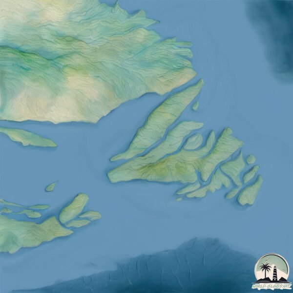
Geography and size of Chapel Island
Size: 8.94 km²
Coastline: 17.9 km
Ocean: Atlantic Ocean
Sea: Labrador Sea
Continent: North America
Chapel Island is a Small Island spanning 8.9 km² with a coastline of 17.9 km.
Archipel: –
Tectonic Plate: North America – Covers North America and parts of the Atlantic and Arctic Oceans, characterized by diverse geological features and varying levels of seismic activity.
The geographic heart of the island is pinpointed at these coordinates:
Latitude: 49.14246645 / Longitude: -54.88094247
Climate and weather of Chapel Island
Climate Zone: Continental
Climate Details: Subarctic Climate
Temperature: Cold Summer
Climate Characteristics: Characterized by long, extremely cold winters and short, cool summers, often found in northern latitudes of North America and Eurasia.
Topography and nature of Chapel Island
Timezone: UTC-03:30
Timezone places: America/St_Johns
Max. Elevation: 159 m
Mean Elevation: 25 m
Vegetation: Mixed Forest
Tree Coverage: 87%
The mean elevation is 25 m. The highest elevation on the island reaches approximately 159 meters above sea level. The island is characterized by Plains: Flat, low-lying lands characterized by a maximum elevation of up to 200 meters. On islands, plains are typically coastal lowlands or central flat areas.
Dominating Vegetation: Mixed Forest
A combination of both deciduous and evergreen trees, often found in transitional zones between forest types. These forests offer a diverse habitat for various wildlife species. Chapel Island has a tree cover of 87 %.
Vegetation: 8 vegetation zones – Very Highly Diverse Island
Islands in this range are ecological powerhouses, showcasing a wide array of vegetation zones. Each zone, from lush rainforests to arid scrublands, coastal mangroves to mountainous regions, contributes to a complex and interdependent ecosystem. These islands are often hotspots of biodiversity, supporting numerous species and intricate ecological processes.
Infrastructure and Travelling to Chapel Island
Does the island have a public airport? no.
There is no public and scheduled airport on Chapel Island. The nearest airport is St. Lewis (Fox Harbour) Airport, located 11 km away.
Does the island have a major port? no.
There are no major ports on Chapel Island. The closest major port is GRAND NARROWS, approximately 25 km away.
The mean population of Chapel Island is 1 per km². Chapel Island is Uninhabited. The island belongs to Canada.
The name of the island resonates across different cultures and languages. Here is how it is known around the world: Arabic: جزيرة كيب بريتون; German: Kap-Breton-Insel; Spanish: Isla del Cabo Bretón; French: île du Cap-Breton; Portuguese: Ilha Cape Breton; Russian: Кейп-Бретон; Chinese: 布雷顿角岛
Continuing your journey, Dunnage Island is the next notable island, situated merely km away.
Chapel Island, Cumbria

Canada is classified as Developed region: G7: Group of Seven – Major advanced economies, including Canada, France, Germany, Italy, Japan, the United Kingdom, and the United States. The level of income is High income: OECD.
News – Latest Updates and Headlines from Chapel Island
Stay informed with the most recent news and important headlines from Chapel Island. Here’s a roundup of the latest developments.
Please note: The data used here has been primarily extracted from satellite readings. Deviations from exact values may occur, particularly regarding the height of elevations and population density. Land area and coastline measurements refer to average values at mean high tide.