Welcome to Chauqes, a Temperate island in the South Pacific Ocean, part of the majestic Pacific Ocean. This guide offers a comprehensive overview of what makes Chauqes unique – from its geography and climate to its population, infrastructure, and beyond. Dive into the details:
Geography and size of Chauqes
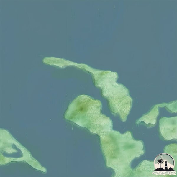
Size: 3.278 km²
Coastline: 15.5 km
Ocean: Pacific Ocean
Sea: South Pacific Ocean
Continent: South America
Chauqes is a Small Island spanning 3.3 km² with a coastline of 15.5 km.
Archipel: –
Tectonic Plate: South America – A major plate covering the South American continent and part of the Atlantic Ocean, known for the Andes mountain range and significant seismic and volcanic activity.
The geographic heart of the island is pinpointed at these coordinates:
Latitude: -42.25863272 / Longitude: -73.15646929
Climate and weather of Chauqes
Climate Zone: Temperate
Climate Details: Temperate Oceanic Climate
Temperature: Warm Summer
Climate Characteristics: Known for its moderate year-round temperatures with ample rainfall and no dry season. Warm summers are characteristic.
Topography and nature of Chauqes
Timezone: UTC-04:00
Timezone places: America/La_Paz
Max. Elevation: 28 m
Mean Elevation: 6 m
Vegetation: Evergreen Broadleaf Forest
Tree Coverage: 59%
The mean elevation is 6 m. The highest elevation on the island reaches approximately 28 meters above sea level. The island is characterized by Plains: Flat, low-lying lands characterized by a maximum elevation of up to 200 meters. On islands, plains are typically coastal lowlands or central flat areas.
Dominating Vegetation: Evergreen Broadleaf Forest
Characterized by dense, lush canopies of broadleaf trees that retain their leaves year-round. These forests are typically found in tropical and subtropical regions and are known for their high biodiversity. Chauqes has a tree cover of 59 %.
Vegetation: 4 vegetation zones – Diverse Island
Four distinct vegetation zones mark these islands as ecologically diverse. They might feature varied landscapes such as forests, beaches, grasslands, and rocky areas. Such diversity reflects the island’s complex ecological interactions and varied habitats, which can support a rich array of wildlife and plant species.
Infrastructure and Travelling to Chauqes
Does the island have a public airport? no.
There is no public and scheduled airport on Chauqes. The nearest airport is Mocopulli Airport, located 60 km away.
Does the island have a major port? no.
There are no major ports on Chauqes. The closest major port is PUERTO QUEMCHI, approximately 35 km away.
The mean population of Chauqes is 22 per km². Chauqes is Gently Populated. The island belongs to Chile.
Continuing your journey, Buta Chauques is the next notable island, situated merely km away.
DUB INC - Chaque nouvelle page (Clip)
Shanks - Rayleigh Haki
onepiece #onepieceedit #edit #haki #rayleigh #fyp #fypシ #epicmoment ...
onepiece #onepieceedit #edit #haki #rayleigh #fyp #fypシ #epicmoment #epicmomentanime #anime #animeedit #shanks ...
All the SECRET LOCATIONS in Star Stable Online
All the currently available secret locations in Star Stable Online! ...
All the currently available secret locations in Star Stable Online! Let me know if I missed something and I can help you out in the ...
"5 Common Genetic Mistakes Gamefowl Breeders Make"
Are you unintentionally setting back your bloodline? In this episode ...
Are you unintentionally setting back your bloodline? In this episode of The Art of Breeding, we reveal the 5 most common genetic ...
Les 3 tribus les plus dangereuses du monde #shorts
Which club song is the best 🤩? #song #club #barcelona #realmadrid #liverpool #chelsea
Which club song is the best ? #song #club #barcelona #realmadrid ...
Which club song is the best ? #song #club #barcelona #realmadrid #liverpool #chelsea Check it out for football updates .
Les plus belles îles du Cap-Vert
Retrouvez ce voyage avec les meilleurs bons plans du moment et le ...
Retrouvez ce voyage avec les meilleurs bons plans du moment et le guide Partir à personnaliser ...
📍¿Oíste hablar de Maria Island, en Tasmania, Australia?
Oíste hablar de Maria Island, en Tasmania, Australia? Algunos datos a ...
Oíste hablar de Maria Island, en Tasmania, Australia? Algunos datos a tener en cuenta si quieres visitar este lugar: ✨ Esta ...
Apocalypse de Zombie... ! 🥺😱 #shorts #acting #humour #zombiesurvival #video #animation #comedy
Super Mario 3D World + Bowser's Fury - All Daisy Cat Locations
This video shows every Lost Daisy Kitten location in Super Mario 3D ...
This video shows every Lost Daisy Kitten location in Super Mario 3D World + Bowser's Fury for Nintendo Switch. The areas the ...
Thimbles astuces. Astuces 1xbet thimble. Failles sur le jeu thimble. Failles 1xbet. Thimbles.
Astuces sur le thimble. 1xgames astuces Thimble. Code Promo 1xbet : ...
Astuces sur le thimble. 1xgames astuces Thimble. Code Promo 1xbet : FATI9 #thimbles #astuce thimbles #thimble 1xgames ...
Chaques 🔥||4finger+gyro|| ipad readmi ||5genration
Chaques ||4finger+gyro|| ipad readmi ||5genration * * * * * * #iPhone ...
Chaques ||4finger+gyro|| ipad readmi ||5genration * * * * * * #iPhone 13 #ipad 5 #readminote8pro. In PUBG: BATTLEGROUNDS ...
Surviving Every Netflix Love Story
Rebecca Zamolo survives every first love story from the Netflix show ...
Rebecca Zamolo survives every first love story from the Netflix show Bridgerton to the Kissing Booth in real life. It all started When ...
IHNIM I 04 XODRE CLEMENT KATRAWI - KAKATI LO ME NËNË
KAKATI LO ME NËNË Auteur : CLEMENT KATRAWI Interprete : TREHLE CICA ...
KAKATI LO ME NËNË Auteur : CLEMENT KATRAWI Interprete : TREHLE CICA Production et réalisation : Imag'in Production ...
Shubh-chaques (offical music in Minecraft 😈
Herobrine X Daku Edit | Min #minecraft #viral #gaming ft.Herobrine ...
Herobrine X Daku Edit | Min #minecraft #viral #gaming ft.Herobrine Daku edit minecraft animation video . This is the super ...
Sanji encontrou o Luffy a beira da morte
Anime: One Piece -------------------------------------------- Me segue ...
FIFA But Playstyle = Team
I made a team for each playstyle and it's time to see which one is the ...
I made a team for each playstyle and it's time to see which one is the best! Imperialism Style! if u are reading this subscribe pls.
VOICI COMMENT FAIRE POUR JOUER GRATUITEMENT SUR 1XBET
Salut regarder cette vidéo vous comprenez que pratiquement je joue ...
Salut regarder cette vidéo vous comprenez que pratiquement je joue seulement gratuitement sur 1xbet. Je fais moins des dépôts, ...
La isla más austral de Chile que muchos quisieran tener 🌎🇨🇱
En el fin del mundo, donde los vientos del Drake rugen sin descanso, ...
En el fin del mundo, donde los vientos del Drake rugen sin descanso, Chile mantiene una presencia silenciosa pero poderosa: ...
Beach Buggy Racing ALL Easter Eggs Windows 11
How to find the Secret Locations of all the Easter Eggs in Beach Buggy ...
How to find the Secret Locations of all the Easter Eggs in Beach Buggy Racing. Amazon Daily Deals-
https://amzn.to/3MsbaJL ...
The Crew® 2 - Key West épreuve Chaebung - Powerboat
Pense à t'abonner ▻
https://bit.ly/3jwBvIj et à mettre un pouce bleu si tu as aimé 🙂 --------------------------------------- Lord Of ...
Best WEAPONS in 99 Nights in The Forest... (ROBLOX)
Best WEAPONS in 99 Nights in The Forest... (ROBLOX) Follow me on ...
Minecraft - All Biomes
All 65 Biomes in Minecraft. List Plains Sunflower Plains Snowy Plains ...
All 65 Biomes in Minecraft. List Plains Sunflower Plains Snowy Plains Ice Spikes Desert Swamp Mangrove Swamp Forest Flower ...
Beach Buggy RacinG 🏎ALL Easter EGGS Collect 🥚🤪🔥🔥🙏😉#beachbuggyracing #trending #gaming
MAX LE VAGABOND - ROAD TRIP AUSTRALIA
2 mois à traverser l'Australie d'Est en Ouest ° De Cairns à Perth en ...
2 mois à traverser l'Australie d'Est en Ouest ° De Cairns à Perth en passant par Darwin. De Mars à Juin 2018 Des moments ...
Chile is classified as Emerging region: G20: Group of Twenty – Major economies comprising both developed and emerging countries, representing the world’s largest economies. The level of income is Upper middle income.
News – Latest Updates and Headlines from Chauqes
Stay informed with the most recent news and important headlines from Chauqes. Here’s a roundup of the latest developments.
Loading...
Please note: The data used here has been primarily extracted from satellite readings. Deviations from exact values may occur, particularly regarding the height of elevations and population density. Land area and coastline measurements refer to average values at mean high tide.