Chiruchen To
Welcome to Chiruchen To, a Temperate island in the Japan Sea, part of the majestic Pacific Ocean. This guide offers a comprehensive overview of what makes Chiruchen To unique – from its geography and climate to its population, infrastructure, and beyond. Dive into the details:
- Geography and Size: Explore the island’s size and location.
- Climate and Weather: Weather patterns and temperature.
- Topography and Nature: Uncover the natural wonders of the island.
- Infrastructure and Travelling: Insights on reaching, staying, and making the most of your visit.
- News and Headlines: Latest News.
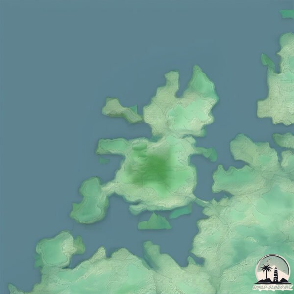
Geography and size of Chiruchen To
Size: 9.345 km²
Coastline: 26.5 km
Ocean: Pacific Ocean
Sea: Japan Sea
Continent: Asia
Chiruchen To is a Small Island spanning 9.3 km² with a coastline of 26.5 km.
Archipel: –
Tectonic Plate: Amur – A minor tectonic plate in the region of the Amur River at the border of Russia and China, involved in complex interactions with the Pacific and Eurasian plates.
The geographic heart of the island is pinpointed at these coordinates:
Latitude: 34.99412028 / Longitude: 128.63574251
Climate and weather of Chiruchen To
Climate Zone: Temperate
Climate Details: Monsoon-Influenced Humid Subtropical Climate
Temperature: Hot Summer
Climate Characteristics: Known for hot, humid summers with significant monsoon rains, contrasted by mild, drier winters.
Topography and nature of Chiruchen To
Timezone: UTC+09:00
Timezone places: Asia/Tokyo
Max. Elevation: 128 m
Mean Elevation: 50 m
Vegetation: Mixed Forest
Tree Coverage: 73%
The mean elevation is 50 m. The highest elevation on the island reaches approximately 128 meters above sea level. The island is characterized by Plains: Flat, low-lying lands characterized by a maximum elevation of up to 200 meters. On islands, plains are typically coastal lowlands or central flat areas.
Dominating Vegetation: Mixed Forest
A combination of both deciduous and evergreen trees, often found in transitional zones between forest types. These forests offer a diverse habitat for various wildlife species. Chiruchen To has a tree cover of 73 %.
Vegetation: 7 vegetation zones – Very Highly Diverse Island
Islands in this range are ecological powerhouses, showcasing a wide array of vegetation zones. Each zone, from lush rainforests to arid scrublands, coastal mangroves to mountainous regions, contributes to a complex and interdependent ecosystem. These islands are often hotspots of biodiversity, supporting numerous species and intricate ecological processes.
Infrastructure and Travelling to Chiruchen To
Does the island have a public airport? no.
There is no public and scheduled airport on Chiruchen To. The nearest airport is Gimhae International Airport, located 36 km away.
Does the island have a major port? no.
There are no major ports on Chiruchen To. The closest major port is CHINAE, approximately 12 km away.
The mean population of Chiruchen To is 723 per km². Chiruchen To is Densely Populated. The island belongs to South Korea.
Continuing your journey, Koje To is the next notable island, situated merely km away.
Chilcheon Island - a short trip during chuseok holidays in Korea


South Korea is classified as Emerging region: MIKT: Mexico, Indonesia, South Korea, and Turkey – Economies recognized for their development potential and emerging market status. The level of income is High income: OECD.
News – Latest Updates and Headlines from Chiruchen To
Stay informed with the most recent news and important headlines from Chiruchen To. Here’s a roundup of the latest developments.
Please note: The data used here has been primarily extracted from satellite readings. Deviations from exact values may occur, particularly regarding the height of elevations and population density. Land area and coastline measurements refer to average values at mean high tide.