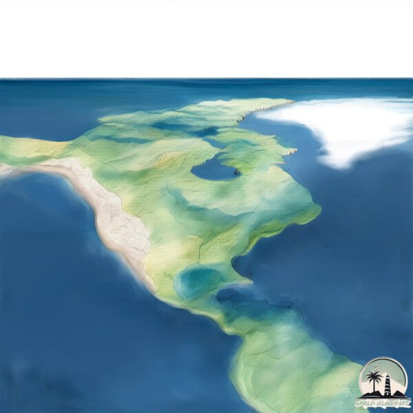
Welcome to Circle Island, a Continental island in the Gulf of St. Lawrence, part of the majestic Atlantic Ocean. This guide offers a comprehensive overview of what makes Circle Island unique – from its geography and climate to its population, infrastructure, and beyond. Dive into the details:
Geography and size of Circle Island
Size: 2.042 km²
Coastline: 8.9 km
Ocean: Atlantic Ocean
Sea: Gulf of St. Lawrence
Continent: North America
Circle Island is a Small Island spanning 2 km² with a coastline of 8.9 km.
Archipel: –
Tectonic Plate: North America – Covers North America and parts of the Atlantic and Arctic Oceans, characterized by diverse geological features and varying levels of seismic activity.
The geographic heart of the island is pinpointed at these coordinates:
Latitude: 47.57211892 / Longitude: -55.80788024
Climate and weather of Circle Island
Climate Zone: Continental
Climate Details: Subarctic Climate
Temperature: Cold Summer
Climate Characteristics: Characterized by long, extremely cold winters and short, cool summers, often found in northern latitudes of North America and Eurasia.
Topography and nature of Circle Island
Timezone: UTC-03:30
Timezone places: America/St_Johns
Max. Elevation: 49 m
Mean Elevation: 23 m
Vegetation: Evergreen Needleleaf Forest
Tree Coverage: 71%
The mean elevation is 23 m. The highest elevation on the island reaches approximately 49 meters above sea level. The island is characterized by Plains: Flat, low-lying lands characterized by a maximum elevation of up to 200 meters. On islands, plains are typically coastal lowlands or central flat areas.
Dominating Vegetation: Evergreen Needleleaf Forest
Dominated by evergreen coniferous trees such as pines and firs, which retain their needle-like leaves throughout the year. These forests are often found in cooler climates. Circle Island has a tree cover of 71 %.
Vegetation: 3 vegetation zones – Moderately Diverse Island
These islands start to show a broader range of ecological niches. With three vegetation zones, they may offer a mix of ecosystems like coastal areas, inland woods, and perhaps a distinct wetland or dry area. This diversity supports a wider range of flora and fauna, making these islands more ecologically complex than those with minimal diversity.
Infrastructure and Travelling to Circle Island
Does the island have a public airport? no.
There is no public and scheduled airport on Circle Island. The nearest airport is Texada Gillies Bay Airport, located 44 km away.
Does the island have a major port? no.
There are no major ports on Circle Island. The closest major port is NANOOSE HARBOR, approximately 25 km away.
The mean population of Circle Island is 0 per km². Circle Island is Uninhabited. The island belongs to Canada.
Continuing your journey, Merasheen is the next notable island, situated merely km away.
Oahu Circle Island Tour (Top 5 in 2024)
Oahu Circle Island tour is coming up next. If you are planning to travel Hawaii in 2024 then here are the best tours that you will find ...Oahu Circle Island Tour (Top 5 in 2024)
Oahu Circle Island tour is coming up next. If you are planning to ...
Oahu Circle Island tour is coming up next. If you are planning to travel Hawaii in 2024 then here are the best tours that you will find ...
Oahu Circle Island Tour Review & Vlog | Royal Star Hawaii
Join us on a 9-Hour Bus Tour of the Island of Oahu, Hawaii! The Royal ...
Join us on a 9-Hour Bus Tour of the Island of Oahu, Hawaii! The Royal Star Hawaii Oahu Grand Circle Island Tour is a full loop ...
Best of Hawaii in 8 Hours: Oahu Circle Island Tour
Want to know where we stopped? Want to customize your own Oahu guided ...
Want to know where we stopped? Want to customize your own Oahu guided tour? Click below for information on the best Oahu ...
Iceland's BEST route for sightseeing | The Golden Circle
Get the full guide! ❄️ ...
Best Of Oahu Circle Island Tour | See All The Sites
Tour around the island of Oahu and see the best sites during a great ...
Tour around the island of Oahu and see the best sites during a great day of sightseeing. From Waikiki up to the beaches on the ...
Circle Island Resort perfect for family bonding this Summer #satisfying #asmr #summer
Things to Do Oahu | Circle Island Tour
Nature's breathtaking spectacle awaits you on this epic adventure ...
Nature's breathtaking spectacle awaits you on this epic adventure around the island! Book Circle Island Tour at Link in Bio!
Circle Island Tour in Honolulu Hawaii
We joined another tour with our event organizer, the circle island ...
We joined another tour with our event organizer, the circle island tour. It's a tour around Honolulu. There are lookout stops like ...
You HAVE to book the Oahu Ultimate Circle Island Tour 🚌☀️🌺🌊
FOLLOW ME ON SOCIALS ♥️ Instagram: ii_ofthetiger TikTok: ...
FOLLOW ME ON SOCIALS ♥️ Instagram: ii_ofthetiger TikTok: shanicechristina Website: ...
Waikiki Trolley vs Circle Island Tour | OAHU
Waikiki Trolley vs Circle Island Tour: Exploring Oahu in Two Unique ...
Waikiki Trolley vs Circle Island Tour: Exploring Oahu in Two Unique Ways Discovering the beauty of Oahu can be done in ...
Circle Island Tour of Oahu, Hawaii with Tropical Hawaiian Tours! Try us! 👏🦭🤙🤙🏽🎉🌴🏄♀️🌺🚌
Spanish Tours in Oahu, Hawaii Click here to see our tours ...
Circle Island Tour: Waikiki to Polynesian Culture Center
Join us on an unforgettable Circle Island Tour in Oahu, Hawaii! We ...
Join us on an unforgettable Circle Island Tour in Oahu, Hawaii! We booked this amazing add-on option through the Polynesian ...
A Floating Circular Island — El Ojo, Argentina #Shorts #Facts #DidYouKnow #QuickFacts
An island that rotates like a giant eye on water. Off Argentina's ...
An island that rotates like a giant eye on water. Off Argentina's Paraná Delta lies El Ojo, a perfectly round island that slowly spins ...
Hawaii Oahu Circle Island Tour
The full day tour takes you to Diamond Head, Kahala Estates, Halona ...
The full day tour takes you to Diamond Head, Kahala Estates, Halona “Blow Hole” Lookout, Nuuanu Pali Lookout, Chinaman's Hat ...
A circle island tour with us!
😱😱 CIRCLE ISLAND RESORT 💖💖 #shortvideo #shorts #viralvideo
Circle island Tour of Oahu, Hawaii, the 18 stops tour! #hawaii #travel #spanishtours #privatetours
Spanish Tours in Oahu, Hawaii To book Circle island tour with 18 stops ...
Spanish Tours in Oahu, Hawaii To book Circle island tour with 18 stops click here here ...
Island and You 5-Star Oahu Circle Island Tour
oahuhawaii #oahu.
oahuhawaii #oahu.
Oahu Self Guided Circle Island Tour
Hey guys This was our first full day in Hawaii and wanted to go around ...
Hey guys This was our first full day in Hawaii and wanted to go around the whole island seeing as much as we could see in ...
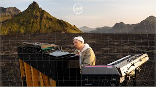
Ólafur Arnalds live from Hafursey, in Iceland for Cercle
Ólafur Arnalds performing live with his band from the volcanic ...
Ólafur Arnalds performing live with his band from the volcanic wilderness of Iceland, in Hafursey, Myrdalssandur, Kötlujökull, Katla ...
VALUE Circle Island Tour| 7 hours → 8 min | OAHU
Waikiki is great - but to see the REAL Oahu, you've got to get out of ...
Waikiki is great - but to see the REAL Oahu, you've got to get out of the concrete jungle of Waikiki. FULL ARTICLE HERE ...
Experience Oahu’s Grand Circle Island Tour: A Complete Adventure
Discover Oahu's best spots on the Grand Circle Island Tour! 🏝️ From ...
Discover Oahu's best spots on the Grand Circle Island Tour! 🏝️ From beaches to mountains, it's a journey of a lifetime. Have you ...
Circle Island Tours of Oahu, Hawaii | E Noa Tours
Preview top island tours of Oahu including North Shore, Windward and ...
Preview top island tours of Oahu including North Shore, Windward and East Shore. Daily trips from Waikiki hotels to exotic ...
Perfect Circle Island. Aliens or nature? 👽🤷! #argentina #phenomenon #geography #shortsexcellence
Hawaii Island Tour (Oahu Circle Island Tour)
If you only had ONE full day in Hawaii, what would you do? I would ...
If you only had ONE full day in Hawaii, what would you do? I would want to snorkel with turtles, buy souvenirs, eat pineapples, ...
Canada is classified as Developed region: G7: Group of Seven – Major advanced economies, including Canada, France, Germany, Italy, Japan, the United Kingdom, and the United States. The level of income is High income: OECD.
News – Latest Updates and Headlines from Circle Island
Stay informed with the most recent news and important headlines from Circle Island. Here’s a roundup of the latest developments.
Loading...
Please note: The data used here has been primarily extracted from satellite readings. Deviations from exact values may occur, particularly regarding the height of elevations and population density. Land area and coastline measurements refer to average values at mean high tide.