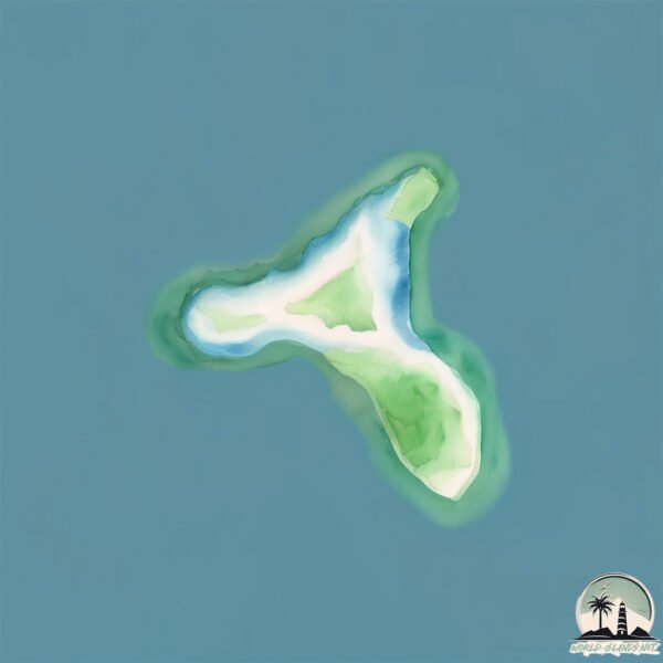
Welcome to Cole Island, a Tropical island in the Coral Sea, part of the majestic Pacific Ocean. This guide offers a comprehensive overview of what makes Cole Island unique – from its geography and climate to its population, infrastructure, and beyond. Dive into the details:
Geography and size of Cole Island
Size: 0.102 km²
Coastline: 1.8 km
Ocean: Pacific Ocean
Sea: Coral Sea
Continent: Oceania
Cole Island is a Tiny Island spanning 0.102 km² with a coastline of 1.8 km.
Archipel: Whitsunday Island – A collection of 74 islands off the central coast of Queensland, Australia, known for their stunning natural beauty and as a gateway to the Great Barrier Reef.
Tectonic Plate: Australia – A major tectonic plate covering Australia, New Zealand, and parts of the Indian and Pacific Oceans, known for its relative stability and occasional seismic activity.
The geographic heart of the island is pinpointed at these coordinates:
Latitude: -20.42433618 / Longitude: 149.00738971
Climate and weather of Cole Island
Climate Zone: Tropical
Climate Details: Tropical Savanna, Wet
Temperature: Hot
Climate Characteristics: Defined by distinct wet and dry seasons with high temperatures year-round. Pronounced rainfall occurs during the wet season, while the dry season is marked by drought.
Topography and nature of Cole Island
Timezone: UTC+10:00
Timezone places: Australia/Sydney
Max. Elevation: -6 m
Mean Elevation: -13 m
Vegetation: Evergreen Needleleaf Forest
Tree Coverage: 69%
The mean elevation is -13 m. Remarkably, this unique island barely emerges above the sea level, showcasing nature’s fascinating interplay with the ocean. The island is characterized by Plains: Flat, low-lying lands characterized by a maximum elevation of up to 200 meters. On islands, plains are typically coastal lowlands or central flat areas.
Dominating Vegetation: Evergreen Needleleaf Forest
Dominated by evergreen coniferous trees such as pines and firs, which retain their needle-like leaves throughout the year. These forests are often found in cooler climates. Cole Island has a tree cover of 69 %.
Vegetation: 1 vegetation zones – Minimal Diversity Island
These islands exhibit the most basic level of ecological diversity, often characterized by a single dominant vegetation type. This could be due to extreme environmental conditions, limited land area, or significant human impact. They represent unique ecosystems where specific species have adapted to thrive in these singular environments.
Infrastructure and Travelling to Cole Island
Does the island have a public airport? no.
There is no public and scheduled airport on Cole Island. The nearest airport is Hamilton Island Airport, located 9 km away.
Does the island have a major port? no.
There are no major ports on Cole Island. The closest major port is MACKAY, approximately 80 km away.
The mean population of Cole Island is 1 per km². Cole Island is Gently Populated. The island belongs to Australia.
Continuing your journey, Shaw is the next notable island, situated merely km away.
Exploring the Historic Cole Island
In this video I take a kayak trip to a small island just off the shore. Historically, Cole Island was strategically important to the Royal ...Exploring the Historic Cole Island
In this video I take a kayak trip to a small island just off the ...
In this video I take a kayak trip to a small island just off the shore. Historically, Cole Island was strategically important to the Royal ...
Canada's Secret Islands: Cole Island
Historic Cole Island is located in Esquimalt Harbour on the west coast ...
Historic Cole Island is located in Esquimalt Harbour on the west coast of British Columbia. Because of its close proximity to ...
Cole Island, Lost History #americanhistory #jesuits #colonialhistory
Cole Island 2016
Scott Elliott captures Cole Island Island from above in celebration of ...
Scott Elliott captures Cole Island Island from above in celebration of George and Mike Buero's 80th birthday.
Cole Island at Sunrise – A Quiet Look at a Forgotten Place
Cole Island is one of the quieter historic sites in Esquimalt Harbor, ...
Cole Island is one of the quieter historic sites in Esquimalt Harbor, just off the coast of Colwood on southern Vancouver Island.
cole Island
Welcome back, and welcome to Cole Island. The Esquimalt harbour is a ...
Welcome back, and welcome to Cole Island. The Esquimalt harbour is a wonderful place for kayaking adventures. On this ...
WestShore Unlimited Episode #3 - Cole Island, View Royal and Lynne's Little Elf Garden Centre
Cole Island
We took a trip to on of the most significant historical sites in BC ...
We took a trip to on of the most significant historical sites in BC and learned how some West Shore residents have helped restore ...
Cole Island
SUP Rebel Adventures Presents: Cole Island a beautiful and historic ...
SUP Rebel Adventures Presents: Cole Island a beautiful and historic island off the coast of Victoria BC Canada. This is just one of ...
They Just Walked Away | Cole Island | Abandoned Ammunition Base | Destination Adventure
I finally got the chance to visit Cole Island, in Victoria BC. This ...
I finally got the chance to visit Cole Island, in Victoria BC. This island was for many years, an ammunitions storage depot for the ...
Cole Island, Victoria BC, Canada
Cole Island is a small island situated not far from the shore in ...
Cole Island is a small island situated not far from the shore in Esquimalt Harbour close to Victoria, BC. Construction of the first ...
American YouTuber Arrested After Visiting Forbidden Island | 10 News First
An American YouTuber has been arrested after travelling to a ...
An American YouTuber has been arrested after travelling to a restricted island and leaving a can of diet coke as a gift for the ...
cole island
sup #isup #standuppaddleboarding.
sup #isup #standuppaddleboarding.
Crosby Land Company Presents: Coles Island, Jasper County, South Carolina
Property Listing: ...
Coles Island Video HD
This video is about Coles Island Video HD.
This video is about Coles Island Video HD.
Cole Island from Above | Reflections Over Esquimalt Harbor
Vancouver Island Drones is a Westshore-based aerial media and ...
Vancouver Island Drones is a Westshore-based aerial media and storytelling brand focused on calm, cinematic perspectives of ...
Green Island vs Fitzroy Island : Which one should you visit?
Choosing Your Tropical Escape: Green Island vs Fitzroy Island in ...
Choosing Your Tropical Escape: Green Island vs Fitzroy Island in Cairns Queensland When your on holiday its hard to decide ...
Cold Island - Full Song 5.2 (My Singing Monsters)
Cold Island's full song with bbli$zard! All island songs: ...
Cold Island's full song with bbli$zard! All island songs: ...
Frizzy P & Mr Cole - ISLANDS (Official video)
Frizzy P & Mr Cole - ISLANDS Track from LADI DADI II EP Vinyl for sale ...
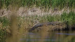
Strand Feeding in Cole Creek at Cole Island
Strand feeding is an amazing act of nature to observe. Cole Creek at ...
Strand feeding is an amazing act of nature to observe. Cole Creek at Cole Island is one of the locations one can observe strand ...
Cole Island Kayak
Time lapse of Kayaking to Cole Island and around Esquimalt Harbour. ...
Time lapse of Kayaking to Cole Island and around Esquimalt Harbour. Canon G12 Gopro HD Music - Joel Plaskett - Three ...
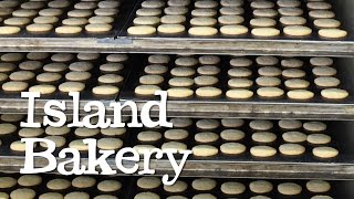
Abel & Cole visit Island Bakery
Joe and Dawn Reade set up the Island Bakery Organics on the Isle of ...
Joe and Dawn Reade set up the Island Bakery Organics on the Isle of Mull, where Joe has lived since the age of 11. He met Dawn ...
Cole island (almost completed 🥶)
Forgotten History on Lake Champlain: Isaac Jogues and Cole Island
Come along with us as we explore a forgotten historic site, Cole ...
Come along with us as we explore a forgotten historic site, Cole Island on Lake Champlain where Father Isaac Jogues was killed ...
Lego Ninjago The Island: Cole's Character Spot
Everything in this video belongs to Lego and Wildbrain, I own nothing.
Everything in this video belongs to Lego and Wildbrain, I own nothing.
Australia is classified as Developed region: nonG7: Developed economies outside of the Group of Seven, characterized by high income and advanced economic structures. The level of income is High income: OECD.
News – Latest Updates and Headlines from Cole Island
Stay informed with the most recent news and important headlines from Cole Island. Here’s a roundup of the latest developments.
Loading...
Please note: The data used here has been primarily extracted from satellite readings. Deviations from exact values may occur, particularly regarding the height of elevations and population density. Land area and coastline measurements refer to average values at mean high tide.