Coronation

Welcome to Coronation, a Polar island in the South Atlantic Ocean, part of the majestic Indian Ocean. This guide offers a comprehensive overview of what makes Coronation unique – from its geography and climate to its population, infrastructure, and beyond. Dive into the details:
- Geography and Size: Explore the island’s size and location.
- Climate and Weather: Weather patterns and temperature.
- Topography and Nature: Uncover the natural wonders of the island.
- Infrastructure and Travelling: Insights on reaching, staying, and making the most of your visit.
- News and Headlines: Latest News.
Geography and size of Coronation
Size: 39.5 km²
Coastline: 85.1 km
Ocean: Indian Ocean
Sea: South Atlantic Ocean
Continent: Oceania
Coronation is a Medium Island spanning 40 km² with a coastline of 85 km.
Archipel: South Orkney Islands – A group of islands in the Southern Ocean, near Antarctica, known for their stark, icy landscapes and research stations.
Tectonic Plate: Australia – A major tectonic plate covering Australia, New Zealand, and parts of the Indian and Pacific Oceans, known for its relative stability and occasional seismic activity.
The geographic heart of the island is pinpointed at these coordinates:
Latitude: -58.51039346 / Longitude: -37.75897913
Climate and weather of Coronation
Climate Zone: Polar
Climate Details: Tundra
Temperature: Cold
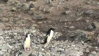
Climate Characteristics: The tundra climate features long, extremely cold winters and short, cool summers. Vegetation is limited to mosses, lichens, and small shrubs due to the low temperatures and short growing seasons. Biodiversity is low, but some specialized species thrive.
Topography and nature of Coronation
Timezone: UTC+08:00
Timezone places: Australia/Perth
Max. Elevation: 99 m
Mean Elevation: 39 m
Vegetation: Snow and Ice Covered
Tree Coverage: 10%
The mean elevation is 39 m. The highest elevation on the island reaches approximately 99 meters above sea level. The island is characterized by Plains: Flat, low-lying lands characterized by a maximum elevation of up to 200 meters. On islands, plains are typically coastal lowlands or central flat areas.
Dominating Vegetation: Snow and Ice Covered
These areas are permanently or seasonally covered in snow and ice, with little to no vegetation, such as polar regions and high mountains. Coronation has a tree cover of 10 %.
Vegetation: 8 vegetation zones – Very Highly Diverse Island
Islands in this range are ecological powerhouses, showcasing a wide array of vegetation zones. Each zone, from lush rainforests to arid scrublands, coastal mangroves to mountainous regions, contributes to a complex and interdependent ecosystem. These islands are often hotspots of biodiversity, supporting numerous species and intricate ecological processes.
Infrastructure and Travelling to Coronation
Does the island have a public airport? no.
There is no public and scheduled airport on Coronation. The nearest airport is East Kimberley Regional (Kununurra) Airport, located 425 km away.
Does the island have a major port? no.
There are no major ports on Coronation. The closest major port is ELLEFSEN HARBOR, approximately 11 km away.
The mean population of Coronation is 0 per km². Coronation is Uninhabited. The island belongs to Australia.
Continuing your journey, Signy is the next notable island, situated merely km away.
Coronation Island - South Orkneys


Australia is classified as Developed region: nonG7: Developed economies outside of the Group of Seven, characterized by high income and advanced economic structures. The level of income is High income: OECD.
News – Latest Updates and Headlines from Coronation
Stay informed with the most recent news and important headlines from Coronation. Here’s a roundup of the latest developments.
Please note: The data used here has been primarily extracted from satellite readings. Deviations from exact values may occur, particularly regarding the height of elevations and population density. Land area and coastline measurements refer to average values at mean high tide.