Crocodile Island
Welcome to Crocodile Island, a Tropical island in the Timor Sea, part of the majestic Indian Ocean. This guide offers a comprehensive overview of what makes Crocodile Island unique – from its geography and climate to its population, infrastructure, and beyond. Dive into the details:
- Geography and Size: Explore the island’s size and location.
- Climate and Weather: Weather patterns and temperature.
- Topography and Nature: Uncover the natural wonders of the island.
- Infrastructure and Travelling: Insights on reaching, staying, and making the most of your visit.
- News and Headlines: Latest News.
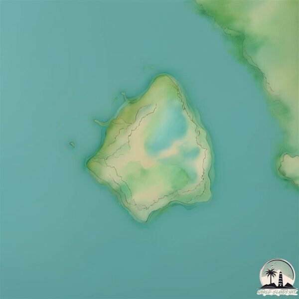
Geography and size of Crocodile Island
Size: 0.383 km²
Coastline: 2.6 km
Ocean: Indian Ocean
Sea: Timor Sea
Continent: Oceania
Crocodile Island is a Tiny Island spanning 0.383 km² with a coastline of 2.6 km.
Archipel: –
Tectonic Plate: Australia – A major tectonic plate covering Australia, New Zealand, and parts of the Indian and Pacific Oceans, known for its relative stability and occasional seismic activity.
The geographic heart of the island is pinpointed at these coordinates:
Latitude: -12.68462171 / Longitude: 130.62520821
Climate and weather of Crocodile Island
Climate Zone: Tropical
Climate Details: Tropical Savanna, Wet
Temperature: Hot
Climate Characteristics: Defined by distinct wet and dry seasons with high temperatures year-round. Pronounced rainfall occurs during the wet season, while the dry season is marked by drought.
Topography and nature of Crocodile Island
Timezone: UTC+09:30
Timezone places: Australia/Adelaide
Max. Elevation: 4 m
Mean Elevation: 1 m
Vegetation: Herbaceous Cover
Tree Coverage: 0%
The mean elevation is 1 m. The highest elevation on the island reaches approximately 4 meters above sea level. The island is characterized by Plains: Flat, low-lying lands characterized by a maximum elevation of up to 200 meters. On islands, plains are typically coastal lowlands or central flat areas.
Dominating Vegetation: Herbaceous Cover
Comprising mainly of grasses, herbs, and ferns, these areas are common in prairies, meadows, and savannas, and can vary widely in species composition. Crocodile Island has a tree cover of 0 %.
Vegetation: 1 vegetation zones – Minimal Diversity Island
These islands exhibit the most basic level of ecological diversity, often characterized by a single dominant vegetation type. This could be due to extreme environmental conditions, limited land area, or significant human impact. They represent unique ecosystems where specific species have adapted to thrive in these singular environments.
Infrastructure and Travelling to Crocodile Island
Does the island have a public airport? no.
There is no public and scheduled airport on Crocodile Island. The nearest airport is Darwin International Airport / RAAF Darwin, located 41 km away.
Does the island have a major port? no.
There are no major ports on Crocodile Island. The closest major port is DARWIN, approximately 34 km away.
The mean population of Crocodile Island is 0 per km². Crocodile Island is Uninhabited. The island belongs to Australia.
Continuing your journey, Indian is the next notable island, situated merely km away.
【ENG SUB】Crocodile Island | Action, Adventure, Drama | Chinese Movie 2024 | iQIYI Movie English


Australia is classified as Developed region: nonG7: Developed economies outside of the Group of Seven, characterized by high income and advanced economic structures. The level of income is High income: OECD.
News – Latest Updates and Headlines from Crocodile Island
Stay informed with the most recent news and important headlines from Crocodile Island. Here’s a roundup of the latest developments.
- Harry and Meghan hit back after 35,000-strong Australian petition demands couple not use taxpayer's cash to fund visit - lbc.co.ukby "australia" - Google News on 25 March 2026
Harry and Meghan hit back after 35,000-strong Australian petition demands couple not use taxpayer's cash to fund visit lbc.co.uk
- Australia Moving to Ban R&D Tax Credits on Tobacco, Gambling - Tobacco Reporterby "australia" - Google News on 25 March 2026
Australia Moving to Ban R&D Tax Credits on Tobacco, Gambling Tobacco Reporter
- Ante Suto on his rapid Hibs rise as Australia call up sparks World Cup dream - Daily Recordby "australia" - Google News on 25 March 2026
Ante Suto on his rapid Hibs rise as Australia call up sparks World Cup dream Daily Record
- Relay brings celebration to Titmus' hometown - Inside The Gamesby "australia" - Google News on 25 March 2026
Relay brings celebration to Titmus' hometown Inside The Games
- Australia and the Path Not Taken: The Declining Independence and Influence of Middle Powers - Global Policy Journalby "australia" - Google News on 25 March 2026
Australia and the Path Not Taken: The Declining Independence and Influence of Middle Powers Global Policy Journal
- ITV commissions Australia-set thriller Two Birds from AC Chapter One, starring Sheridan Smith - C21mediaby "australia" - Google News on 25 March 2026
ITV commissions Australia-set thriller Two Birds from AC Chapter One, starring Sheridan Smith C21media
- Australia is running on empty – in more ways than one - Lowy Instituteby "australia" - Google News on 25 March 2026
Australia is running on empty – in more ways than one Lowy Institute
- Glamorgan sign Australian fast bowler Hadley - BBCby "australia" - Google News on 25 March 2026
Glamorgan sign Australian fast bowler Hadley BBC
- Jordan Brook reveals brother flew from Australia to see him in hospital - The Sunby "australia" - Google News on 25 March 2026
Jordan Brook reveals brother flew from Australia to see him in hospital The Sun
- MAFS Australia first look sees marriages crumble as two brides move out and one flies home - Heart Radioby "australia" - Google News on 25 March 2026
MAFS Australia first look sees marriages crumble as two brides move out and one flies home Heart Radio
Please note: The data used here has been primarily extracted from satellite readings. Deviations from exact values may occur, particularly regarding the height of elevations and population density. Land area and coastline measurements refer to average values at mean high tide.