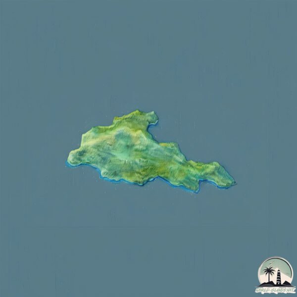
Welcome to Cuvier, a Temperate island in the South Pacific Ocean, part of the majestic Pacific Ocean. This guide offers a comprehensive overview of what makes Cuvier unique – from its geography and climate to its population, infrastructure, and beyond. Dive into the details:
Geography and size of Cuvier
Size: 2.074 km²
Coastline: 9.6 km
Ocean: Pacific Ocean
Sea: South Pacific Ocean
Continent: Oceania
Cuvier is a Small Island spanning 2.1 km² with a coastline of 9.6 km.
Archipel: Polynesia – A region of more than 1,000 islands in the central and southern Pacific Ocean, known for their diverse Polynesian cultures, stunning landscapes, and marine biodiversity.
Tectonic Plate: Australia – A major tectonic plate covering Australia, New Zealand, and parts of the Indian and Pacific Oceans, known for its relative stability and occasional seismic activity.
The geographic heart of the island is pinpointed at these coordinates:
Latitude: -36.43641192 / Longitude: 175.77161324
Climate and weather of Cuvier
Climate Zone: Temperate
Climate Details: Temperate Oceanic Climate
Temperature: Warm Summer
Climate Characteristics: Known for its moderate year-round temperatures with ample rainfall and no dry season. Warm summers are characteristic.
Topography and nature of Cuvier
Timezone: UTC+12:00
Timezone places: Pacific/Auckland
Max. Elevation: 119 m
Mean Elevation: 59 m
Vegetation: Evergreen Needleleaf Forest
Tree Coverage: 99%
The mean elevation is 59 m. The highest elevation on the island reaches approximately 119 meters above sea level. The island is characterized by Plains: Flat, low-lying lands characterized by a maximum elevation of up to 200 meters. On islands, plains are typically coastal lowlands or central flat areas.
Dominating Vegetation: Evergreen Needleleaf Forest
Dominated by evergreen coniferous trees such as pines and firs, which retain their needle-like leaves throughout the year. These forests are often found in cooler climates. Cuvier has a tree cover of 99 %.
Vegetation: 2 vegetation zones – Low Diversity Island
Islands with two distinct vegetation zones offer slightly more ecological variety. These zones could be due to differences in elevation, moisture, or other environmental factors. While still limited in biodiversity, these islands may offer a contrast between the two zones, such as a coastline with mangroves and an inland area with grassland.
Infrastructure and Travelling to Cuvier
Does the island have a public airport? no.
There is no public and scheduled airport on Cuvier. The nearest airport is Auckland International Airport, located 125 km away.
Does the island have a major port? no.
There are no major ports on Cuvier. The closest major port is AUCKLAND, approximately 119 km away.
The mean population of Cuvier is per km². Cuvier is . The island belongs to New Zealand.
Continuing your journey, Great Mercury is the next notable island, situated merely km away.
Hauraki Gulf Fishing - the AMAZING Cuvier Island
The Hauraki Gulf is a fishermans paradise and it doesn't get much better than Cuvier Island! Some of the Ultimate Charters ...Hauraki Gulf Fishing - the AMAZING Cuvier Island
The Hauraki Gulf is a fishermans paradise and it doesn't get much ...
The Hauraki Gulf is a fishermans paradise and it doesn't get much better than Cuvier Island! Some of the Ultimate Charters ...
Jetski Fishing Cuvier for Snapper, Kingfish and more!
How far? – Cuvier Island #zoomtest #p1000
New Chums Beach - Cuvier Island #zoomtest #zoomlens #nikonp950 ...
New Chums Beach - Cuvier Island #zoomtest #zoomlens #nikonp950 #nikonp1000 #nikon #howfar #bigking #volcano #dog ...
Kayak Fishing & Exploring Cuvier Island with Viking Kayaks
Kayak fishing and exploring the remote Cuvier Islands, mothership ...
Kayak fishing and exploring the remote Cuvier Islands, mothership trip. This video is small taste of the adventure Stephen Tapp ...
Cuvier Island video
This video is about Cuvier Island video.
This video is about Cuvier Island video.
Big Kingfish slow trolling Cuvier Island, New Zealand
Micro jigging around Cuvier Island and Channel Island Fishing
Fishing around Cuvier and Channel Island microjigging for mainly ...
Fishing around Cuvier and Channel Island microjigging for mainly snapper and kingis with a few other species. A big thanks to ...
Fishing newzealand, curvier island
Shimano grappler Lg series on stella 4000 xg with ocea braid x8 p.e 1.5.
Shimano grappler Lg series on stella 4000 xg with ocea braid x8 p.e 1.5.
24 Hours on Offshore Island | Spearfishing, Big Kingfish & Overnight Boat Camp!
Join us on an unforgettable 24 hour trip to a stunning offshore island ...
Join us on an unforgettable 24 hour trip to a stunning offshore island in New Zealand! In this action-packed video, we take you on ...
NZ bellbird dawn chorus on Cuvier Island (Repanga)
The song culture of NZ bellbirds (Anthornis melanura) differs markedly ...
The song culture of NZ bellbirds (Anthornis melanura) differs markedly from place to place. Here is a very special dawn chorus ...
Kayak Fishing Merc's and Cuvier Islands
Mother ship trip November 2013.
Mother ship trip November 2013.
Vanavara mission to cuvier island
Description.
Description.
Cuvier Island Lighthouse First Order Optic Assembly - Tiritiri Matangi Museum
The Cuvier Lighthouse optic is an octagonal first order rotating type, ...
The Cuvier Lighthouse optic is an octagonal first order rotating type, containing catadioptric (reflecting) and dioptric (refracting) ...
Spearfishing Cuvier & GBI 2014
Great Barrier Island Spearfishing trip! 4 days on the M.V. Te Wairoa ...
Great Barrier Island Spearfishing trip! 4 days on the M.V. Te Wairoa from Coromandel up to Cuvier Island & Great Barrier Island, ...
Jigging king fish newzealand curvier island 3
Whitianga + Cuvier Kingfish Mission 01
Fishing the shallows of Whitianga Bay, before blasting out to Cuvier ...
Fishing the shallows of Whitianga Bay, before blasting out to Cuvier to get absolutely railed! Live baiting, stick baiting and ...
Cuvier Snapper
Snapper speared at Cuvier Island, Coromandel Peninsula, NZ.
Snapper speared at Cuvier Island, Coromandel Peninsula, NZ.
Terrible news for Cathedral Cove lovers this summer! | Newshub
DoC has confirmed the popular Cathedral Cove tracks will NOT be open ...
DoC has confirmed the popular Cathedral Cove tracks will NOT be open this summer. #fyp #foryoupage #cathedralcove ...
Offshore fishing mayhem & feisty snapper on jigs - RSK Ep 28
The last part of our mothership trip at Cuvier Island in New Zealand ...
The last part of our mothership trip at Cuvier Island in New Zealand continues. With the shallows around the island producing ...
Cuvier spearfishing trip 2011
Ron Bakker spearfishing in New Zealand. Subscribe to my channel for ...
Ron Bakker spearfishing in New Zealand. Subscribe to my channel for future reviews and tutorials on leading brands like Beuchat ...
MVI 0520
Whai trip 2016 dolphins at Cuvier Island.
Whai trip 2016 dolphins at Cuvier Island.
Meritor, Sept '20
Brendon & Matt repeat the annual winter 'Hard Bastards' trip on ...
Brendon & Matt repeat the annual winter 'Hard Bastards' trip on Meritor. This time, the voyage takes us to Great Barrier Island, and ...
This Fishing Spot Is A Hidden Gem!
We put an end to a serious fishing drought and head out for an epic ...
We put an end to a serious fishing drought and head out for an epic session in the shallows on the West Coast of New Zealand!
Scary Places Australia: this is Cahill Crossing In Northern Territory deadly crocs| full video 👇
The first tiger shark (Galeocerdo cuvier) ever tagged in the Cook Islands was released off Aitutaki.
New Zealand is classified as Developed region: G7: Group of Seven – Major advanced economies, including Canada, France, Germany, Italy, Japan, the United Kingdom, and the United States. The level of income is High income: OECD.
News – Latest Updates and Headlines from Cuvier
Stay informed with the most recent news and important headlines from Cuvier. Here’s a roundup of the latest developments.
Loading...
Please note: The data used here has been primarily extracted from satellite readings. Deviations from exact values may occur, particularly regarding the height of elevations and population density. Land area and coastline measurements refer to average values at mean high tide.