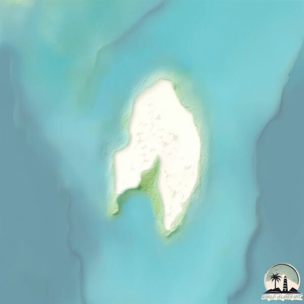
Welcome to Dar Solum, a Dry island in the Red Sea, part of the majestic Indian Ocean. This guide offers a comprehensive overview of what makes Dar Solum unique – from its geography and climate to its population, infrastructure, and beyond. Dive into the details:
Geography and size of Dar Solum
Size: 2.794 km²
Coastline: 8.8 km
Ocean: Indian Ocean
Sea: Red Sea
Continent: Africa
Dar Solum is a Small Island spanning 2.8 km² with a coastline of 8.8 km.
Archipel: Dahlak Archipelago – Located in the Red Sea near Eritrea, known for their historical significance, coral reefs, and diverse marine life.
Tectonic Plate: India – A major tectonic plate that initially moved northward at a rapid pace before colliding with the Eurasian Plate. This collision is responsible for the uplift of the Himalayas and the Tibetan Plateau.
The geographic heart of the island is pinpointed at these coordinates:
Latitude: 15.97473222 / Longitude: 39.94654972
Climate and weather of Dar Solum
Climate Zone: Dry
Climate Details: Hot Deserts Climate
Temperature: Hot
Climate Characteristics: Dominated by extremely hot temperatures, this climate is marked by minimal rainfall and barren landscapes. Nights often experience drastic temperature drops.
Topography and nature of Dar Solum
Timezone: UTC+03:00
Timezone places: Asia/Riyadh
Max. Elevation: 6 m
Mean Elevation: 5 m
Vegetation: Sparse Vegetation
Tree Coverage: 2%
The mean elevation is 5 m. The highest elevation on the island reaches approximately 6 meters above sea level. The island is characterized by Plains: Flat, low-lying lands characterized by a maximum elevation of up to 200 meters. On islands, plains are typically coastal lowlands or central flat areas.
Dominating Vegetation: Sparse Vegetation
These regions have limited plant growth, typically due to extreme conditions like aridity or poor soils. Vegetation is scattered and consists of hardy plant species. Dar Solum has a tree cover of 2 %.
Vegetation: 3 vegetation zones – Moderately Diverse Island
These islands start to show a broader range of ecological niches. With three vegetation zones, they may offer a mix of ecosystems like coastal areas, inland woods, and perhaps a distinct wetland or dry area. This diversity supports a wider range of flora and fauna, making these islands more ecologically complex than those with minimal diversity.
Infrastructure and Travelling to Dar Solum
Does the island have a public airport? no.
There is no public and scheduled airport on Dar Solum. The nearest airport is Massawa International Airport, located 71 km away.
Does the island have a major port? no.
There are no major ports on Dar Solum. The closest major port is MITSIWA HARBOR, approximately 65 km away.
The mean population of Dar Solum is 5 per km². Dar Solum is Gently Populated. The island belongs to Eritrea.
Continuing your journey, Duladia is the next notable island, situated merely km away.
His mother is bringing the mistress home. His wife is bringing the truth. Guess who wins?
Subscribe + turn on notifications so you don't miss an update Comment “NEXT!” if you want the next part faster Next ...His mother is bringing the mistress home. His wife is bringing the truth. Guess who wins?
Subscribe + turn on notifications so you don't miss an update Comment ...
Subscribe + turn on notifications so you don't miss an update Comment “NEXT!” if you want the next part faster Next ...
[Full Tập] 🔪 Một người không sợ chết, một người đã chết một lần
Tôi sẽ chọn lọc cho bạn những bộ phim lồng tiếng chất lượng, kịch bản ...
Tôi sẽ chọn lọc cho bạn những bộ phim lồng tiếng chất lượng, kịch bản độc đáo sáng tạo, diễn viên vừa đẹp lại vừa diễn xuất tốt ...
【Multi Sub】A Guard by Day, a Guardian by Night—and the Man Who Would Avenge His Father.
Show Title:《 XXX 》. All content on this channel is officially licensed ...
Show Title:《 XXX 》. All content on this channel is officially licensed ✓ All series on this channel are artistic expressions, ...
[Full Tập] Kiếp trước bị thiêu chết, kiếp này tôi trở về—trên đầu kẻ phản bội, tôi nhảy như nhảy hội
Tôi sẽ chọn lọc cho bạn những bộ phim lồng tiếng chất lượng, kịch bản ...
Tôi sẽ chọn lọc cho bạn những bộ phim lồng tiếng chất lượng, kịch bản độc đáo sáng tạo, diễn viên vừa đẹp lại vừa diễn xuất tốt ...
THE LIGHT GATE – OPEN MIC NIGHT, Q&A
THE LIGHT GATE – OPEN MIC NIGHT, Q&A The time has come for another ...
THE LIGHT GATE – OPEN MIC NIGHT, Q&A The time has come for another rare Open Mic Q&A episode of the Light Gate!
15 Impossible Hidden Wonders You Must See Before You Die
15 Impossible Hidden Wonders You Must See Before You Die 15 impossible ...
15 Impossible Hidden Wonders You Must See Before You Die 15 impossible hidden wonders you must see before you die ...
📍【已完结!】年番4 |百世轮回淬体,玄黄要塞大战,净莲妖火空间终极对决!!| 斗破苍穹年番 Battle Through the Heavens|Chinese Donghua
欢迎来到动漫喵 我会每日分享动漫精彩片段,请点点订阅 和赞 支持我哦~ 请和我多多评论互动,我会努力回复评论的~✨ 【斗 ...
欢迎来到动漫喵 我会每日分享动漫精彩片段,请点点订阅 和赞 支持我哦~ 请和我多多评论互动,我会努力回复评论的~✨ 【斗 ...
[Full Tập] Anh bảo cô bẩn, cô không nói gì — vì cô biết, thứ bẩn nhất… là cái nhìn của anh
Tôi sẽ chọn lọc cho bạn những bộ phim lồng tiếng chất lượng, kịch bản ...
Tôi sẽ chọn lọc cho bạn những bộ phim lồng tiếng chất lượng, kịch bản độc đáo sáng tạo, diễn viên vừa đẹp lại vừa diễn xuất tốt ...
[Full Tập] “Em nghĩ anh đến làm gì?” “… Làm chồng?” “Không, đến đòi nợ.”
Tôi sẽ chọn lọc cho bạn những bộ phim lồng tiếng chất lượng, kịch bản ...
Tôi sẽ chọn lọc cho bạn những bộ phim lồng tiếng chất lượng, kịch bản độc đáo sáng tạo, diễn viên vừa đẹp lại vừa diễn xuất tốt ...
คิดว่าได้สามีธรรมดา ที่ไหนได้เขาคือซีอีโอ แต่ดันเปิดเผยตัวเองไม่เคยสำเร็จ
คอมเมนต์ “ต่อ!” ถ้าอยากให้ลงตอนต่อไปไวขึ้น ✓ กดติดตาม + กดกระดิ่ง ...
คอมเมนต์ “ต่อ!” ถ้าอยากให้ลงตอนต่อไปไวขึ้น ✓ กดติดตาม + กดกระดิ่ง เพื่อไม่พลาดตอนใหม่ Part ถัดไป:
https://linktr.ee/gzjw888 ...
6.5 IS STACKED! Everything You Need To Know - Banners, New Map, Free Jahoda & More | Genshin Impact
WANT TO PULL SKIRK & ESCOFFIER?! SAVE UP TO 30% OFF Genesis Crystals, ...
WANT TO PULL SKIRK & ESCOFFIER?! SAVE UP TO 30% OFF Genesis Crystals, By Using MY LINK for TOPUPlive: ...
Cenk and Mahassine's wedding in Greece was a stunning event that made headlines
How to Find 3 Special Sentinel Ships S Class in No Man's Sky
How to Find 3 Special Sentinel Ships S Class in No Man's Sky in this ...
How to Find 3 Special Sentinel Ships S Class in No Man's Sky in this video i will show you How to Find 3 Special Sentinel Ships S ...
이란 AI 핵전쟁 성경은 이미 알고 있었다
마지막예언 #곡과마곡 #적그리스도 #666 #아마겟돈 #요한계시록 #에스겔38장 #다니엘예언 #종말징조 ...
마지막예언 #곡과마곡 #적그리스도 #666 #아마겟돈 #요한계시록 #에스겔38장 #다니엘예언 #종말징조 ...
Most Beautiful Places in Dubai 🌴
nature #travel #adventure #shorts #explore #dubai.
nature #travel #adventure #shorts #explore #dubai.
เจ้าบ่าวหนีหน้าแท่นวิวาห์💍 ฉันเลยชี้หน้าคนในงาน บอกว่าเอานายละกัน!
ฉันจะคัดสรรซีรีส์พากย์ไทยดีๆ ที่เนื้อเรื่องแปลกใหม่ สนุกสนานไม่ซ้ำใคร ...
ฉันจะคัดสรรซีรีส์พากย์ไทยดีๆ ที่เนื้อเรื่องแปลกใหม่ สนุกสนานไม่ซ้ำใคร นักแสดงหล่อสวย ฝีมือการแสดงเยี่ยม มาให้คุณได้รับชมแบบเต็มๆ ...
What If Japan Never Attacked Pearl Harbor?
The fate of the world changed when the Japanese Kido Butai turned ...
The fate of the world changed when the Japanese Kido Butai turned south instead of east toward Pearl Harbor, leaving the United ...
My best friends waiting for me every day on the cat island.
Every day I come here and sit on this bench and drink tea. I know I ...
Every day I come here and sit on this bench and drink tea. I know I won't be alone here. That's why I bring cat food. These cats ...
The Homeless Boy Who Became History's Greatest Conqueror | Genghis Khan
Majestic and unstoppable. Miracle Studios brings you the untold story ...
Majestic and unstoppable. Miracle Studios brings you the untold story of history's greatest conqueror — not the legend, not the ...
[เต็มเรื่อง] ชายาที่สุดใน👑 ก้มลงปกปักรักษาผู้หญิงที่ท้องกับเขา!
ฉันจะคัดสรรซีรีส์พากย์ไทยดีๆ ที่เนื้อเรื่องแปลกใหม่ สนุกสนานไม่ซ้ำใคร ...
ฉันจะคัดสรรซีรีส์พากย์ไทยดีๆ ที่เนื้อเรื่องแปลกใหม่ สนุกสนานไม่ซ้ำใคร นักแสดงหล่อสวย ฝีมือการแสดงเยี่ยม มาให้คุณได้รับชมแบบเต็มๆ ...
Rogue Piece | KANEKI & SOLEMN LAMENT! (Showcase & Guide) #roguepiece #roblox
In this video I will be covering the newest update in rogue piece, ...
In this video I will be covering the newest update in rogue piece, which has added ken kaneki (from tokyo ghoul) as the newest ...
วันหมั้น เขาวิ่งไปหาคนอื่น💍แค่สามวัน ฉันมีสามีใหม่!
ฉันจะคัดสรรซีรีส์พากย์ไทยดีๆ ที่เนื้อเรื่องแปลกใหม่ สนุกสนานไม่ซ้ำใคร ...
ฉันจะคัดสรรซีรีส์พากย์ไทยดีๆ ที่เนื้อเรื่องแปลกใหม่ สนุกสนานไม่ซ้ำใคร นักแสดงหล่อสวย ฝีมือการแสดงเยี่ยม มาให้คุณได้รับชมแบบเต็มๆ ...
Ученые обнаружили, что скрывается ПОДО ЛЬДОМ в Гренландии!
Гренландия — это не просто самый большой остров планеты. Это ...
Гренландия — это не просто самый большой остров планеты. Это уникальный природный феномен, застывший во ...
[MULTI SUB] [💕新剧]灰姑娘蹬三轮收租偶遇全球影帝,却被轻视羞辱,没想到她反手霸气买下千亿豪宅,隐藏豪门身份揭晓,影帝后悔不已当场跪舔求包养,霸气翻盘爽翻全场!YHDJ
甜剧热播#中国电视剧#霸道总裁和灰姑娘哈喽,大家好~ 这里是甜剧热播 每天更新最新热播精彩短剧 Future TV Copyright ...
甜剧热播#中国电视剧#霸道总裁和灰姑娘哈喽,大家好~ 这里是甜剧热播 每天更新最新热播精彩短剧 Future TV Copyright ...
Владимир Кот и Дикие Мальдивы - Trailer - Vladimir Cat and the Wild Maldives
Дорогие мои зрители, к сожалению я вынужден на 2 недели покинуть Вас! ...
Дорогие мои зрители, к сожалению я вынужден на 2 недели покинуть Вас! Плохо, что выход долгожданного фильма о ...
Eritrea is classified as Least developed region: Countries that exhibit the lowest indicators of socioeconomic development, with the lowest Human Development Index ratings. The level of income is Low income.
News – Latest Updates and Headlines from Dar Solum
Stay informed with the most recent news and important headlines from Dar Solum. Here’s a roundup of the latest developments.
Loading...
Please note: The data used here has been primarily extracted from satellite readings. Deviations from exact values may occur, particularly regarding the height of elevations and population density. Land area and coastline measurements refer to average values at mean high tide.

![[Full Tập] 🔪 Một người không sợ chết, một người đã chết một lần](https://i.ytimg.com/vi/I8HbKfL3JN0/mqdefault.jpg)

![[Full Tập] Kiếp trước bị thiêu chết, kiếp này tôi trở về—trên đầu kẻ phản bội, tôi nhảy như nhảy hội](https://i.ytimg.com/vi/dijdGq3Socw/mqdefault.jpg)


![[Full Tập] Anh bảo cô bẩn, cô không nói gì — vì cô biết, thứ bẩn nhất… là cái nhìn của anh](https://i.ytimg.com/vi/VHBWJD5dmTc/mqdefault.jpg)
![[Full Tập] “Em nghĩ anh đến làm gì?” “… Làm chồng?” “Không, đến đòi nợ.”](https://i.ytimg.com/vi/QHRkFiJmdpE/mqdefault.jpg)


![[เต็มเรื่อง] ชายาที่สุดใน👑 ก้มลงปกปักรักษาผู้หญิงที่ท้องกับเขา!](https://i.ytimg.com/vi/_InRPwTjbMs/mqdefault.jpg)


![[MULTI SUB] [💕新剧]灰姑娘蹬三轮收租偶遇全球影帝,却被轻视羞辱,没想到她反手霸气买下千亿豪宅,隐藏豪门身份揭晓,影帝后悔不已当场跪舔求包养,霸气翻盘爽翻全场!YHDJ](https://i.ytimg.com/vi/zKAq0x3_hj8/mqdefault.jpg)
