Dawanshan Dao
Welcome to Dawanshan Dao, a Temperate island in the South China Sea, part of the majestic Pacific Ocean. This guide offers a comprehensive overview of what makes Dawanshan Dao unique – from its geography and climate to its population, infrastructure, and beyond. Dive into the details:
- Geography and Size: Explore the island’s size and location.
- Climate and Weather: Weather patterns and temperature.
- Topography and Nature: Uncover the natural wonders of the island.
- Infrastructure and Travelling: Insights on reaching, staying, and making the most of your visit.
- News and Headlines: Latest News.
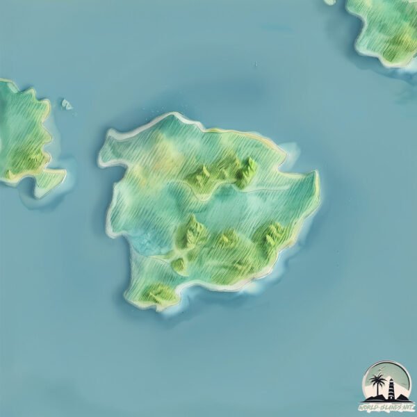
Geography and size of Dawanshan Dao
Size: 8.83 km²
Coastline: 14.3 km
Ocean: Pacific Ocean
Sea: South China Sea
Continent: Asia
Dawanshan Dao is a Small Island spanning 8.8 km² with a coastline of 14.3 km.
Archipel: –
Tectonic Plate: Yangtze – A minor tectonic plate in East Asia, often considered a part of the Eurasian Plate. It’s primarily continental and covers the Yangtze River area in China, playing a significant role in the region’s geological stability.
The geographic heart of the island is pinpointed at these coordinates:
Latitude: 21.9422657 / Longitude: 113.72744846
Climate and weather of Dawanshan Dao
Climate Zone: Temperate
Climate Details: Monsoon-Influenced Humid Subtropical Climate
Temperature: Hot Summer
Climate Characteristics: Known for hot, humid summers with significant monsoon rains, contrasted by mild, drier winters.
Topography and nature of Dawanshan Dao
Timezone: UTC+08:00
Timezone places: Australia/Perth
Max. Elevation: 252 m
Mean Elevation: 118 m
Vegetation: Deciduous Broadleaf Forest
Tree Coverage: 54%
The mean elevation is 118 m. The highest elevation on the island reaches approximately 252 meters above sea level. The island is characterized by Hills: Gently sloping landforms with rounded tops, having a maximum elevation between 200 and 500 meters. Hills contribute to a varied landscape on islands.
Dominating Vegetation: Deciduous Broadleaf Forest
Composed of broadleaf trees that shed their leaves seasonally. These forests are commonly found in temperate zones and experience distinct seasonal changes. Dawanshan Dao has a tree cover of 54 %.
Vegetation: 7 vegetation zones – Very Highly Diverse Island
Islands in this range are ecological powerhouses, showcasing a wide array of vegetation zones. Each zone, from lush rainforests to arid scrublands, coastal mangroves to mountainous regions, contributes to a complex and interdependent ecosystem. These islands are often hotspots of biodiversity, supporting numerous species and intricate ecological processes.
Infrastructure and Travelling to Dawanshan Dao
Does the island have a public airport? no.
There is no public and scheduled airport on Dawanshan Dao. The nearest airport is Macau International Airport, located 26 km away.
Does the island have a major port? no.
There are no major ports on Dawanshan Dao. The closest major port is MACAU, approximately 30 km away.
The mean population of Dawanshan Dao is 48 per km². Dawanshan Dao is Gently Populated. The island belongs to China.
Continuing your journey, Taipa is the next notable island, situated merely km away.
珠海万山群岛


China is classified as Emerging region: BRIC: Brazil, Russia, India, and China – Economies noted for their rapid growth and increasing influence on global affairs. The level of income is Upper middle income.
News – Latest Updates and Headlines from Dawanshan Dao
Stay informed with the most recent news and important headlines from Dawanshan Dao. Here’s a roundup of the latest developments.
Please note: The data used here has been primarily extracted from satellite readings. Deviations from exact values may occur, particularly regarding the height of elevations and population density. Land area and coastline measurements refer to average values at mean high tide.