Welcome to Deceit, a Polar island in the South Atlantic Ocean, part of the majestic Atlantic Ocean. This guide offers a comprehensive overview of what makes Deceit unique – from its geography and climate to its population, infrastructure, and beyond. Dive into the details:
Geography and size of Deceit
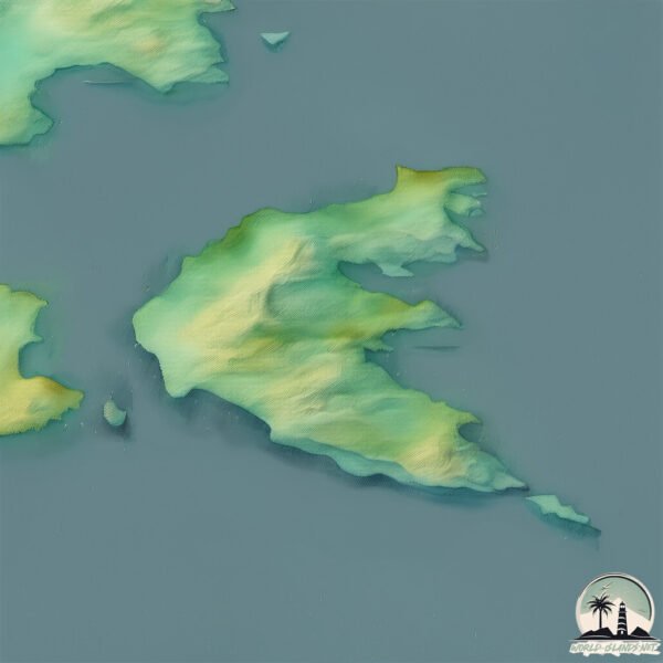
Size: 36.8 km²
Coastline: 54.2 km
Ocean: Atlantic Ocean
Sea: South Atlantic Ocean
Continent: South America
Deceit is a Medium Island spanning 37 km² with a coastline of 54 km.
Archipel: –
Tectonic Plate: Scotia – Situated in the Southern Ocean, surrounding the Scotia Sea, between South America and Antarctica, known for the Scotia Arc and active seismicity.
The geographic heart of the island is pinpointed at these coordinates:
Latitude: -55.86303051 / Longitude: -67.12359439
Climate and weather of Deceit
Climate Zone: Polar
Climate Details: Tundra
Temperature: Cold
Climate Characteristics: The tundra climate features long, extremely cold winters and short, cool summers. Vegetation is limited to mosses, lichens, and small shrubs due to the low temperatures and short growing seasons. Biodiversity is low, but some specialized species thrive.
Topography and nature of Deceit
Timezone: UTC-04:00
Timezone places: America/La_Paz
Max. Elevation: 323 m
Mean Elevation: 138 m
Vegetation: Evergreen Broadleaf Forest
Tree Coverage: 52%
The mean elevation is 138 m. The highest elevation on the island reaches approximately 323 meters above sea level. The island is characterized by Hills: Gently sloping landforms with rounded tops, having a maximum elevation between 200 and 500 meters. Hills contribute to a varied landscape on islands.
Dominating Vegetation: Evergreen Broadleaf Forest
Characterized by dense, lush canopies of broadleaf trees that retain their leaves year-round. These forests are typically found in tropical and subtropical regions and are known for their high biodiversity. Deceit has a tree cover of 52 %.
Vegetation: 10 vegetation zones – Very Highly Diverse Island
Islands in this range are ecological powerhouses, showcasing a wide array of vegetation zones. Each zone, from lush rainforests to arid scrublands, coastal mangroves to mountainous regions, contributes to a complex and interdependent ecosystem. These islands are often hotspots of biodiversity, supporting numerous species and intricate ecological processes.
Infrastructure and Travelling to Deceit
Does the island have a public airport? no.
There is no public and scheduled airport on Deceit. The nearest airport is Malvinas Argentinas Airport, located 167 km away.
Does the island have a major port? no.
There are no major ports on Deceit. The closest major port is PUERTO WILLIAMS, approximately 112 km away.
The mean population of Deceit is 0 per km². Deceit is Uninhabited. The island belongs to Chile.
Continuing your journey, Freycinet is the next notable island, situated merely km away.
Exploring an abandoned Whaling Station on Deception Island | Antarctica
Exploring an ABANDONED WHALING STATION on Deception Island. Step back in time with me as I explore the eerie remains of ...Exploring an abandoned Whaling Station on Deception Island | Antarctica
Exploring an ABANDONED WHALING STATION on Deception Island. Step back ...
Exploring an ABANDONED WHALING STATION on Deception Island. Step back in time with me as I explore the eerie remains of ...
Exploring an abandoned whaling station on Deception Island #shorts #deceptionisland #antarctica
Join me on Antarctica's Deception Island to find out more about the ...
Join me on Antarctica's Deception Island to find out more about the events of the whaling industry and the turn of the 20th Century.
“Deception” island is REAL!
Deception island - Antarctica
Oct 2005 Deception Island may be just a tiny speck in the ocean but ...
Oct 2005 Deception Island may be just a tiny speck in the ocean but it's surprisingly rich in history. We uncover a tale of ghosts, ...
Whalers Bay, Deception Island: A Brief History
An introduction to the discovery and history of Whalers Bay Deception ...
An introduction to the discovery and history of Whalers Bay Deception Island, Antarctica, as well as a guide to what you may see ...
1 Day on Deception Island (Leaves You Speechless!)
Hey Adventurers, this active volcanic caldera in the middle of the ...
Hey Adventurers, this active volcanic caldera in the middle of the Antarctic Ocean is home to a haunting history and today, ...
Deception. Scary/Horror stories.
horror #horrorstories #scary #scarystories On November 13th, 1820, ...
horror #horrorstories #scary #scarystories On November 13th, 1820, American sailor Henry Palmer and his men landed on an ...
Mad Season - River of Deceit (Live at the Moore, Seattle, 1995)
Mad Season performing "River of Deceit" live at the Moore, Seattle, ...
A creature in Deception Island,Antarctica
Can somebody please explain this.
Can somebody please explain this.
Deception Island, Antarctica
In Antarctica the weather didn't start off too great - but things soon ...
In Antarctica the weather didn't start off too great - but things soon changes partway through our day on Deception Island.
Deception Island: The Island that is an Active Volcano Caldera
Explore Deception Island, the Active Antarctic Volcano That's Home to Penguins | National Geographic
Over 100000 breeding pairs of penguins nest on this island—which also ...
Over 100000 breeding pairs of penguins nest on this island—which also happens to be an active volcano. ➡ Subscribe: ...
Deception Island: Explore the Volcanic Wonder of Antarctica!
antarctica #volcano #deceptionisland #travel #tourism Subscribe to ...
antarctica #volcano #deceptionisland #travel #tourism Subscribe to BuzzGeek for more. Like and share to help us grow.
Deception Island: The Island that is an Active Volcano Caldera
Exploring Deception Island 🏔️ | Antarctica’s Mysterious Volcano!
Venture to the eerie Deception Island in Antarctica, a volcanic ...
Venture to the eerie Deception Island in Antarctica, a volcanic caldera surrounded by dramatic landscapes and rich history.
The Deception Island Mystery #scarystories
The Deception Island Mystery Ready to dive into one of the spookiest ...
The Deception Island Mystery Ready to dive into one of the spookiest places on Earth? We're talking about Deception Island, near ...
Deception Island, Antarctica - #Documentary #animals #nature
Deception Island, Antarctica - #Documentary #animals #nature.
Deception Island, Antarctica - #Documentary #animals #nature.
What do they have hidden in deception island?
What do they have hidden in deception island? #antarctica #deception.
What do they have hidden in deception island? #antarctica #deception.
🌋❄️ Deception Island, Antarctica Exploring a Volcanic Haven in the South Shetland Islands ❄️🌋
Stay Empowered: ...
Deception Island: Nature’s Fiery Antarctic Secret
Step into a volcanic wonderland where hot springs meet icy shores. ...
Step into a volcanic wonderland where hot springs meet icy shores. Explore penguin colonies, research stations, and surreal ...
Antarctica's Eerie Secret: Deception Island
Welcome to Deception Island, the eerie secret of Antarctica! In this ...
Welcome to Deception Island, the eerie secret of Antarctica! In this chilling exploration, we uncover the haunting history and ...
Deception Island, Antarctica Abandoned Place #34
Deception Island, Antarctica. Abandoned Place #34 Deception Island is ...
Deception Island, Antarctica. Abandoned Place #34 Deception Island is a tourist destination in Antarctica's freezing South ...
Nancy Drew: Danger on Deception Island
Game: ...
Swim in a Volcano? Discover Deception Island!
Deep in the frozen wilderness of Antarctica lies one of the most ...
Deep in the frozen wilderness of Antarctica lies one of the most surreal places on Earth — Deception Island, a flooded caldera of ...
Deception Island
antarctica #googleearth #islands #research This Antarctic island is ...
antarctica #googleearth #islands #research This Antarctic island is beautiful, and deceptively dangerous. It's an active volcano.
Chile is classified as Emerging region: G20: Group of Twenty – Major economies comprising both developed and emerging countries, representing the world’s largest economies. The level of income is Upper middle income.
News – Latest Updates and Headlines from Deceit
Stay informed with the most recent news and important headlines from Deceit. Here’s a roundup of the latest developments.
Loading...
Please note: The data used here has been primarily extracted from satellite readings. Deviations from exact values may occur, particularly regarding the height of elevations and population density. Land area and coastline measurements refer to average values at mean high tide.