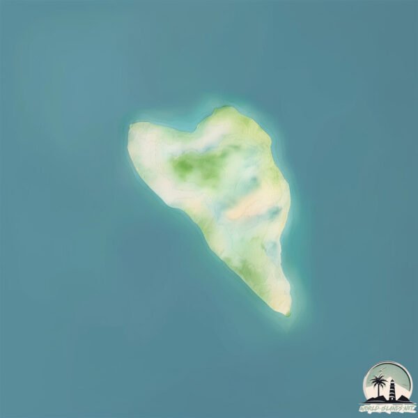
Welcome to Deloraine Island, a Tropical island in the Coral Sea, part of the majestic Pacific Ocean. This guide offers a comprehensive overview of what makes Deloraine Island unique – from its geography and climate to its population, infrastructure, and beyond. Dive into the details:
Geography and size of Deloraine Island
Size: 0.172 km²
Coastline: 1.9 km
Ocean: Pacific Ocean
Sea: Coral Sea
Continent: Oceania
Deloraine Island is a Tiny Island spanning 0.172 km² with a coastline of 1.9 km.
Archipel: Whitsunday Island – A collection of 74 islands off the central coast of Queensland, Australia, known for their stunning natural beauty and as a gateway to the Great Barrier Reef.
Tectonic Plate: Australia – A major tectonic plate covering Australia, New Zealand, and parts of the Indian and Pacific Oceans, known for its relative stability and occasional seismic activity.
The geographic heart of the island is pinpointed at these coordinates:
Latitude: -20.15771499 / Longitude: 149.07361699
Climate and weather of Deloraine Island
Climate Zone: Tropical
Climate Details: Tropical Savanna, Wet
Temperature: Hot
Climate Characteristics: Defined by distinct wet and dry seasons with high temperatures year-round. Pronounced rainfall occurs during the wet season, while the dry season is marked by drought.
Topography and nature of Deloraine Island
Timezone: UTC+10:00
Timezone places: Australia/Sydney
Max. Elevation: -11 m
Mean Elevation: -13 m
Vegetation: Evergreen Broadleaf Forest
Tree Coverage: 81%
The mean elevation is -13 m. Remarkably, this unique island barely emerges above the sea level, showcasing nature’s fascinating interplay with the ocean. The island is characterized by Plains: Flat, low-lying lands characterized by a maximum elevation of up to 200 meters. On islands, plains are typically coastal lowlands or central flat areas.
Dominating Vegetation: Evergreen Broadleaf Forest
Characterized by dense, lush canopies of broadleaf trees that retain their leaves year-round. These forests are typically found in tropical and subtropical regions and are known for their high biodiversity. Deloraine Island has a tree cover of 81 %.
Vegetation: 1 vegetation zones – Minimal Diversity Island
These islands exhibit the most basic level of ecological diversity, often characterized by a single dominant vegetation type. This could be due to extreme environmental conditions, limited land area, or significant human impact. They represent unique ecosystems where specific species have adapted to thrive in these singular environments.
Infrastructure and Travelling to Deloraine Island
Does the island have a public airport? no.
There is no public and scheduled airport on Deloraine Island. The nearest airport is Hayman Island Resort Seaplane Base, located 24 km away.
Does the island have a major port? no.
There are no major ports on Deloraine Island. The closest major port is MACKAY, approximately 107 km away.
The mean population of Deloraine Island is 1 per km². Deloraine Island is Gently Populated. The island belongs to Australia.
Continuing your journey, Whitsunday is the next notable island, situated merely km away.
Exploring Deloraine Island, Whitsundays - aboutfishingnq.com
Checking out Deloraine Island on the outer edge of the Whitsunday Island group.Exploring Deloraine Island, Whitsundays - aboutfishingnq.com
Checking out Deloraine Island on the outer edge of the Whitsunday ...
Checking out Deloraine Island on the outer edge of the Whitsunday Island group.
We spent some time at Deloraine Island Drift Fishing from our Catamaran, in the Whitsundays.
We travelled from Butterfly Bay (on the top of Hook Island) over to ...
We travelled from Butterfly Bay (on the top of Hook Island) over to Deloraine Island to try our hand at Drifting Fishing or Drift ...
Whitehaven, Deloraine and Border island sept 2023 4K
Spring day on the water cruising through Hook passage to Border island ...
Spring day on the water cruising through Hook passage to Border island and then Deloraine. Stop off at Whitehaven before ...
Deloraine & Hazelwood Ride
Deloraine & Hazelwood Island Ride.
Deloraine & Hazelwood Island Ride.
Head of Shelter Bay, Stuart Point, Emily Group, Deloraine Island
These videos are of a coastal aerial video imaging (AVI) survey ...
These videos are of a coastal aerial video imaging (AVI) survey conducted in the Queen Charlotte Sound during 1996 from Head ...
Deloraine and Whitehaven Oct 2020 SD 480p
Ride to Deloraine Reef and Whitehaven beach Whitsundays.
Ride to Deloraine Reef and Whitehaven beach Whitsundays.
Cliff Climbing and Cave Dwelling Adventures! (Sailing SV Sarean) EP. 25
After sailing out to Border Island and declaring it a most beautiful ...
After sailing out to Border Island and declaring it a most beautiful Island, Darren spots tiny Deloraine Islet shimmering in the ...
25lb Brown Trout, caught by Tyson in the Twizel canals. #twizel #browntrout #trout #fishing #nz #rv
Sailing into Freedom Episode 34 Plukky & the Italian girls in Deloraine Island
Captain: Peter aka Plukky Deckhand, cook & talent: Fedra Paccioso ...
Captain: Peter aka Plukky Deckhand, cook & talent: Fedra Paccioso Editor & 2nd mate: Stefania Conte Plukky and the Italian Girls: ...
"Why We Conserve": A Short Film about Connecting to the Important Things
"Why We Conserve" is a short documentary that explores values, avian ...
"Why We Conserve" is a short documentary that explores values, avian ecology, indigenous knowledge, and connection on Cape ...
Fishing For Monster Coral Trout & Giant Trevally at Whitsunday Islands
Arlie Beach, Nara Inlet, Hook Island, and Whitsunday Island| QLD Weekender S1E33
The Queensland Weekender team covers the length and breadth of this ...
The Queensland Weekender team covers the length and breadth of this State with great suggestions for weekends, short breaks ...
Lindeman Group of Islands-Ride
Ducks in Deloraine, Tasmania.
Cruising the Whitsunday Islands
2 days 2 nights sailing tour. Whitsunday Islands area, Great Barrier ...
2 days 2 nights sailing tour. Whitsunday Islands area, Great Barrier Reef, Queensland, Australia.
Primary Schools in Other Country’s VS AUSTRALIA 🇦🇺 #aussiethings #strayanhumour #NitroNostalgia
NORTH COAST OF TASMANIA
West of Devonport are some gorgeous beaches and destinations including ...
West of Devonport are some gorgeous beaches and destinations including Penguin, Burnie and Stanley.
REMOTE fishing for 8 DAYS (Camp Island, North Whitsundays)
My family and I went fishing for 8 days staying at Camp island, which ...
My family and I went fishing for 8 days staying at Camp island, which is North of the Whitsundays. The weather was not ideal but ...
Top 15 Places To Visit In Tasmania, Australia
Flooding expected in Tasmania as storm fronts move across the island state
Tasmania is expecting more flooding as storm fronts move across the ...
Tasmania is expecting more flooding as storm fronts move across the island state. Watch and act alerts were issued Friday night ...
Leaving Butterfly Bay early in the morning. So it's a perfect time for Morning Mood by Edvard Grieg.
It was Monday morning, the 2nd December 2024, and we got underway very ...
It was Monday morning, the 2nd December 2024, and we got underway very early, at around 7am (early for us) leaving Butterfly ...
Oak Island Treasure Found, History Channel Confirms the Discovery!
The legendary Oak Island treasure has finally been found! After years ...
The legendary Oak Island treasure has finally been found! After years of searching, groundbreaking discoveries have confirmed ...
Cape barren island jetty restoration
Part 5: Tiers Cottages-Deloraine - Tasmania
Touring Tasmania. Part 5: Tiers Cottages-Deloraine - Tasmania Great ...
Touring Tasmania. Part 5: Tiers Cottages-Deloraine - Tasmania Great place to stay in upmarket cabins. We stayed there for five ...
Australia is classified as Developed region: nonG7: Developed economies outside of the Group of Seven, characterized by high income and advanced economic structures. The level of income is High income: OECD.
News – Latest Updates and Headlines from Deloraine Island
Stay informed with the most recent news and important headlines from Deloraine Island. Here’s a roundup of the latest developments.
Loading...
Please note: The data used here has been primarily extracted from satellite readings. Deviations from exact values may occur, particularly regarding the height of elevations and population density. Land area and coastline measurements refer to average values at mean high tide.