Welcome to Di Grado, a Temperate island in the Adriatic Sea, part of the majestic Atlantic Ocean. This guide offers a comprehensive overview of what makes Di Grado unique – from its geography and climate to its population, infrastructure, and beyond. Dive into the details:
Geography and size of Di Grado
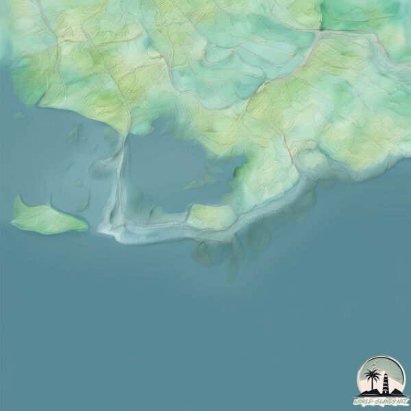
Size: 9.181 km²
Coastline: 25.4 km
Ocean: Atlantic Ocean
Sea: Adriatic Sea
Continent: Europe
Di Grado is a Small Island spanning 9.2 km² with a coastline of 25.4 km.
Archipel: –
Tectonic Plate: Eurasia – One of the world’s largest tectonic plates, the Eurasian Plate covers a significant portion of Europe and Asia. It’s characterized by diverse geological features, including the Ural Mountains, the European Plain, and the Himalayas formed from its collision with the Indian Plate.
The geographic heart of the island is pinpointed at these coordinates:
Latitude: 45.68871335 / Longitude: 13.42822818
Climate and weather of Di Grado
Climate Zone: Temperate
Climate Details: Humid Subtropical Climate
Temperature: Hot Summer
Climate Characteristics: With continuous rainfall and hot summers, this climate is common in some coastal regions, supporting diverse vegetation.
Topography and nature of Di Grado
Timezone: UTC+01:00
Timezone places: Europe/Paris
Max. Elevation: 2 m
Mean Elevation: -1 m
Vegetation: Urban Area
Tree Coverage: 71%
The mean elevation is -1 m. The highest elevation on the island reaches approximately 2 meters above sea level. The island is characterized by Plains: Flat, low-lying lands characterized by a maximum elevation of up to 200 meters. On islands, plains are typically coastal lowlands or central flat areas.
Dominating Vegetation: Urban Area
Regions dominated by human development, including cities and towns, characterized by buildings, roads, and minimal vegetation. Di Grado has a tree cover of 71 %.
Vegetation: 9 vegetation zones – Very Highly Diverse Island
Islands in this range are ecological powerhouses, showcasing a wide array of vegetation zones. Each zone, from lush rainforests to arid scrublands, coastal mangroves to mountainous regions, contributes to a complex and interdependent ecosystem. These islands are often hotspots of biodiversity, supporting numerous species and intricate ecological processes.
Infrastructure and Travelling to Di Grado
Does the island have a public airport? no.
There is no public and scheduled airport on Di Grado. The nearest airport is Trieste–Friuli Venezia Giulia Airport, located 13 km away.
Does the island have a major port? no.
There are no major ports on Di Grado. The closest major port is MONFALCONE, approximately 12 km away.
The mean population of Di Grado is 1212 per km². Di Grado is Densely Populated. The island belongs to Italy.
Continuing your journey, Isola di Polesine is the next notable island, situated merely km away.
Lagune von Grado / laguna di grado Italy
Viele Menschen kennen Grado, aber wer kennt die Lagune von Grado?Lagune von Grado / laguna di grado Italy
Viele Menschen kennen Grado, aber wer kennt die Lagune von Grado?
Viele Menschen kennen Grado, aber wer kennt die Lagune von Grado?
Grado, Isola Barbana 2020
Grado, Isola Barbana 2020.
Grado, Isola Barbana 2020.
The Italian island of Grado And Oglei (Aquileia) - Trip by car In September 2023 [1080p HD]
Sunday trip in September 2023 to Italian Grado and Oglei on the ...
Sunday trip in September 2023 to Italian Grado and Oglei on the mainland (Aquileia). By car from the Slovenian-Italian border it ...
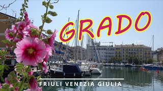
Grado, più di un'isola
Grado è molto più di un'isola e non è solo spiaggia, venite a scoprire ...
Grado è molto più di un'isola e non è solo spiaggia, venite a scoprire in tutte le stagioni la magia della laguna e il fascino del ...
🚲 Visiting Grado by Bike: A Memorable Adventure through Italy's Hidden Gem 🇮🇹
Entering Grado, Italy by bike can be an exciting and unique ...
Entering Grado, Italy by bike can be an exciting and unique experience. Grado is a picturesque town located on a small island in ...
I Still Can’t Believe that this Place Exists on Earth | Blue Grotto in Capri, Italy
laguna di grado e isola di barbana novembre 2022 dji air2s fimi x8 se 2022
Trip to Barbana small Island with church in Grado Italy September 2020
A wonderful trip to small Barbana Island. It only takes 15 to 20 ...
A wonderful trip to small Barbana Island. It only takes 15 to 20 minutes to get there with a boat from Grado town. You bought a ...
Boat trip from Grado to Barbana Island 😀
Die Bootstour auf die Insel Barbana dauert nur eine halbe Stunde. Man ...
Die Bootstour auf die Insel Barbana dauert nur eine halbe Stunde. Man fährt durch die Lagune des oberitalienischen Friauls und ...
Grado: isola del sole 🌞 bici 🚲 natura ⛺ spiaggia ⛱ e relax 😎
Un weekend a Grado per scoprire il suo centro ricco di storia, un giro ...
Un weekend a Grado per scoprire il suo centro ricco di storia, un giro in bici, una visita all'isola di Barbana e tanto relax. Ciao a ...
Discover The Charm Of Grado, Italy On Your Ultimate Summer Getaway!
Summer has arrived in the northern hemisphere and for many people that ...
Summer has arrived in the northern hemisphere and for many people that means spending time at the beach. The island of Grado ...
I almost Drowned in #Croatia visiting the Blue Cave!
I was visiting Croatia and decided to go on a boat tour to the blue ...
I was visiting Croatia and decided to go on a boat tour to the blue cave. I did not know what to expect. It was a calming excursion ...
MOTORCYCLE SOLO WILD CAMPING on a ISLAND IN GRADO, ITALY
MOTORCYCLE SOLO WILD CAMPING on a ISLAND IN GRADO, ITALY HELLO and ...
MOTORCYCLE SOLO WILD CAMPING on a ISLAND IN GRADO, ITALY HELLO and WELCOME BACK to my channel The MINI ...
Grado, Italy - the island of the sunsets on Adriatic Sea. ( Grado stadt in Italien)
Grado is a little island on the Adriatic Sea in Italy, not so far from ...
Grado is a little island on the Adriatic Sea in Italy, not so far from Trieste. (Grado ist ein klein Insel in Italien) It is famous with its ...
Barbana è un’isola nella laguna di Grado, in Friuli Venezia Giulia #fvglive #italy #dji #nature
The Most Beautiful Place to Ride a Bike: Isola di Grado
Isola di Grado, located in the northeastern region of Italy, is a ...
Isola di Grado, located in the northeastern region of Italy, is a charming island in the Adriatic Sea known for its serene atmosphere ...
Grado: L'isola del sole
Scegli l'Isola del sole e del benessere quest'estate, trascorri le tue ...
Scegli l'Isola del sole e del benessere quest'estate, trascorri le tue vacanze in famiglia a Grado! Ti attende un'estesa spiaggia ...
Laguna di Grado (GO)
Laguna di Grado (verso l'isola di Barbana) #grado #barbana #fvg ...
Laguna di Grado (verso l'isola di Barbana) #grado #barbana #fvg #valorealterritorio #click #davidefranchini #franchini.
Isola di Barbana - laguna di Grado
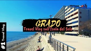
Vlog di viaggio a Grado, l'isola del Sole
Oggi ho viaggiato un po' e sono arrivato a Grado, l'Isola del Sole, in ...
Oggi ho viaggiato un po' e sono arrivato a Grado, l'Isola del Sole, in provincia di Gorizia. La mia permanenza sull'isola è stata ...
@AlexOjeda shows the inside of the amazing Blue Grotto in Italy🇮🇹
In Todays Short I showed the Amazing Grotto Cave in Capri Italy which ...
In Todays Short I showed the Amazing Grotto Cave in Capri Italy which has neon blue water @AlexOjeda #shorts #travel #italy.
White water rafting is fun 🤩
Visit Grado Island: Italy💗
Hey guys I visit Grado and try to film every beautiful place of Grado ...
Hey guys I visit Grado and try to film every beautiful place of Grado island just to show you... Grado is a town and comune in the ...
Italy is classified as Developed region: G7: Group of Seven – Major advanced economies, including Canada, France, Germany, Italy, Japan, the United Kingdom, and the United States. The level of income is High income: OECD.
News – Latest Updates and Headlines from Di Grado
Stay informed with the most recent news and important headlines from Di Grado. Here’s a roundup of the latest developments.
Loading...
Please note: The data used here has been primarily extracted from satellite readings. Deviations from exact values may occur, particularly regarding the height of elevations and population density. Land area and coastline measurements refer to average values at mean high tide.


![The Italian island of Grado And Oglei (Aquileia) - Trip by car In September 2023 [1080p HD]](https://i.ytimg.com/vi/-k7TIQ62V9w/mqdefault.jpg)