Dongdong
Welcome to Dongdong, a Tropical island in the Celebes Sea, part of the majestic Pacific Ocean. This guide offers a comprehensive overview of what makes Dongdong unique – from its geography and climate to its population, infrastructure, and beyond. Dive into the details:
- Geography and Size: Explore the island’s size and location.
- Climate and Weather: Weather patterns and temperature.
- Topography and Nature: Uncover the natural wonders of the island.
- Infrastructure and Travelling: Insights on reaching, staying, and making the most of your visit.
- News and Headlines: Latest News.
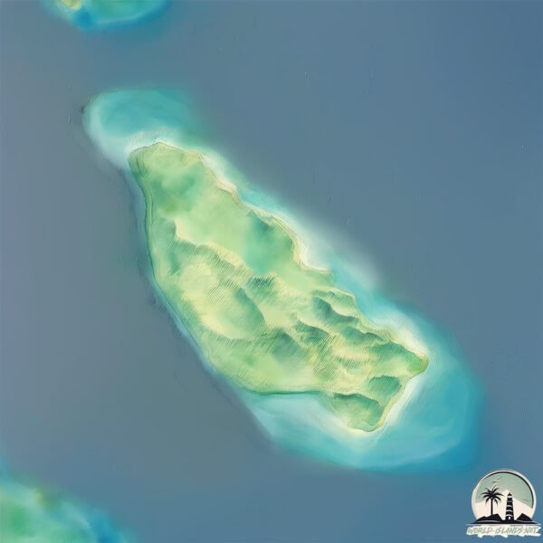
Geography and size of Dongdong
Size: 2.779 km²
Coastline: 8.3 km
Ocean: Pacific Ocean
Sea: Celebes Sea
Continent: Asia
Dongdong is a Small Island spanning 2.8 km² with a coastline of 8.3 km.
Archipel: Malay Archipelago – The world’s largest archipelago, located between mainland Southeast Asia and Australia, known for its immense biodiversity and cultural diversity.
Tectonic Plate: Burma – Also known as the Burma Plate, it’s a minor tectonic plate in Southeast Asia, largely covering Burma (Myanmar) and parts of the Indian Ocean. It’s involved in the subduction process under the Eurasian Plate, contributing to seismic activity in the region.
The geographic heart of the island is pinpointed at these coordinates:
Latitude: 5.84767516 / Longitude: 121.22699316
Climate and weather of Dongdong
Climate Zone: Tropical
Climate Details: Tropical Rainforest Climate
Temperature: Hot
Climate Characteristics: This climate is typified by heavy rainfall throughout the year, high humidity, and consistently high temperatures, leading to lush rainforests and rich biodiversity. Seasonal temperature variations are minimal.
Topography and nature of Dongdong
Timezone: UTC+08:00
Timezone places: Australia/Perth
Max. Elevation: 12 m
Mean Elevation: 11 m
Vegetation: Evergreen Needleleaf Forest
Tree Coverage: 50%
The mean elevation is 11 m. The highest elevation on the island reaches approximately 12 meters above sea level. The island is characterized by Plains: Flat, low-lying lands characterized by a maximum elevation of up to 200 meters. On islands, plains are typically coastal lowlands or central flat areas.
Dominating Vegetation: Evergreen Needleleaf Forest
Dominated by evergreen coniferous trees such as pines and firs, which retain their needle-like leaves throughout the year. These forests are often found in cooler climates. Dongdong has a tree cover of 50 %.
Vegetation: 4 vegetation zones – Diverse Island
Four distinct vegetation zones mark these islands as ecologically diverse. They might feature varied landscapes such as forests, beaches, grasslands, and rocky areas. Such diversity reflects the island’s complex ecological interactions and varied habitats, which can support a rich array of wildlife and plant species.
Infrastructure and Travelling to Dongdong
Does the island have a public airport? no.
There is no public and scheduled airport on Dongdong. The nearest airport is Jolo Airport, located 32 km away.
Does the island have a major port? no.
There are no major ports on Dongdong. The closest major port is JOLO, approximately 32 km away.
The mean population of Dongdong is 188 per km². Dongdong is Moderately Inhabited. The island belongs to Philippines.
Continuing your journey, Pata is the next notable island, situated merely km away.
DongDong Island


Philippines is classified as Emerging region: G20: Group of Twenty – Major economies comprising both developed and emerging countries, representing the world’s largest economies. The level of income is Lower middle income.
News – Latest Updates and Headlines from Dongdong
Stay informed with the most recent news and important headlines from Dongdong. Here’s a roundup of the latest developments.
Please note: The data used here has been primarily extracted from satellite readings. Deviations from exact values may occur, particularly regarding the height of elevations and population density. Land area and coastline measurements refer to average values at mean high tide.