Dongmen Dao
Welcome to Dongmen Dao, a Temperate island in the Eastern China Sea, part of the majestic Pacific Ocean. This guide offers a comprehensive overview of what makes Dongmen Dao unique – from its geography and climate to its population, infrastructure, and beyond. Dive into the details:
- Geography and Size: Explore the island’s size and location.
- Climate and Weather: Weather patterns and temperature.
- Topography and Nature: Uncover the natural wonders of the island.
- Infrastructure and Travelling: Insights on reaching, staying, and making the most of your visit.
- News and Headlines: Latest News.
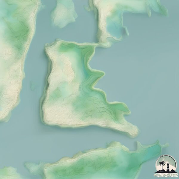
Geography and size of Dongmen Dao
Size: 2.248 km²
Coastline: 8.7 km
Ocean: Pacific Ocean
Sea: Eastern China Sea
Continent: Asia
Dongmen Dao is a Small Island spanning 2.2 km² with a coastline of 8.7 km.
Archipel: –
Tectonic Plate: Okinawa – Located in the East China Sea, near the Ryukyu Islands and Taiwan, it’s involved in the subduction zone between the Philippine Sea Plate and the Eurasian Plate.
The geographic heart of the island is pinpointed at these coordinates:
Latitude: 29.20519871 / Longitude: 121.95562969
Climate and weather of Dongmen Dao
Climate Zone: Temperate
Climate Details: Humid Subtropical Climate
Temperature: Hot Summer
Climate Characteristics: With continuous rainfall and hot summers, this climate is common in some coastal regions, supporting diverse vegetation.
Topography and nature of Dongmen Dao
Timezone: UTC+08:00
Timezone places: Australia/Perth
Max. Elevation: 38 m
Mean Elevation: 33 m
Vegetation: Herbaceous Cover
Tree Coverage: 48%
The mean elevation is 33 m. The highest elevation on the island reaches approximately 38 meters above sea level. The island is characterized by Plains: Flat, low-lying lands characterized by a maximum elevation of up to 200 meters. On islands, plains are typically coastal lowlands or central flat areas.
Dominating Vegetation: Herbaceous Cover
Comprising mainly of grasses, herbs, and ferns, these areas are common in prairies, meadows, and savannas, and can vary widely in species composition. Dongmen Dao has a tree cover of 48 %.
Vegetation: 6 vegetation zones – Very Highly Diverse Island
Islands in this range are ecological powerhouses, showcasing a wide array of vegetation zones. Each zone, from lush rainforests to arid scrublands, coastal mangroves to mountainous regions, contributes to a complex and interdependent ecosystem. These islands are often hotspots of biodiversity, supporting numerous species and intricate ecological processes.
Infrastructure and Travelling to Dongmen Dao
Does the island have a public airport? no.
There is no public and scheduled airport on Dongmen Dao. The nearest airport is Ningbo Lishe International Airport, located 87 km away.
Does the island have a major port? no.
There are no major ports on Dongmen Dao. The closest major port is HAIMEN, approximately 80 km away.
The mean population of Dongmen Dao is 745 per km². Dongmen Dao is Densely Populated. The island belongs to China.
Continuing your journey, Tantou Shan is the next notable island, situated merely km away.
东门岛是石浦镇上一颗闪耀的明珠,目前休渔期间,港口停满渔船。


China is classified as Emerging region: BRIC: Brazil, Russia, India, and China – Economies noted for their rapid growth and increasing influence on global affairs. The level of income is Upper middle income.
News – Latest Updates and Headlines from Dongmen Dao
Stay informed with the most recent news and important headlines from Dongmen Dao. Here’s a roundup of the latest developments.
Please note: The data used here has been primarily extracted from satellite readings. Deviations from exact values may occur, particularly regarding the height of elevations and population density. Land area and coastline measurements refer to average values at mean high tide.