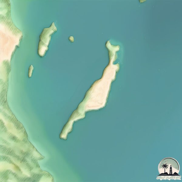
Welcome to Doole, a Dry island in the Indian Ocean, part of the majestic Indian Ocean. This guide offers a comprehensive overview of what makes Doole unique – from its geography and climate to its population, infrastructure, and beyond. Dive into the details:
Geography and size of Doole
Size: 2.779 km²
Coastline: 15 km
Ocean: Indian Ocean
Sea: Indian Ocean
Continent: Oceania
Doole is a Small Island spanning 2.8 km² with a coastline of 15 km.
Archipel: –
Tectonic Plate: Australia – A major tectonic plate covering Australia, New Zealand, and parts of the Indian and Pacific Oceans, known for its relative stability and occasional seismic activity.
The geographic heart of the island is pinpointed at these coordinates:
Latitude: -22.46729092 / Longitude: 114.16347667
Climate and weather of Doole
Climate Zone: Dry
Climate Details: Hot Deserts Climate
Temperature: Hot
Climate Characteristics: Dominated by extremely hot temperatures, this climate is marked by minimal rainfall and barren landscapes. Nights often experience drastic temperature drops.
Topography and nature of Doole
Timezone: UTC+08:00
Timezone places: Australia/Perth
Max. Elevation: 4 m
Mean Elevation: 2 m
Vegetation: Cultivated Land
Tree Coverage: 60%
The mean elevation is 2 m. The highest elevation on the island reaches approximately 4 meters above sea level. The island is characterized by Plains: Flat, low-lying lands characterized by a maximum elevation of up to 200 meters. On islands, plains are typically coastal lowlands or central flat areas.
Dominating Vegetation: Cultivated Land
Areas dedicated to agricultural activities, growing crops like grains, vegetables, and fruits. These lands are usually human-modified landscapes. Doole has a tree cover of 60 %.
Vegetation: 1 vegetation zones – Minimal Diversity Island
These islands exhibit the most basic level of ecological diversity, often characterized by a single dominant vegetation type. This could be due to extreme environmental conditions, limited land area, or significant human impact. They represent unique ecosystems where specific species have adapted to thrive in these singular environments.
Infrastructure and Travelling to Doole
Does the island have a public airport? no.
There is no public and scheduled airport on Doole. The nearest airport is Learmonth Airport, located 25 km away.
Does the island have a major port? no.
There are no major ports on Doole. The closest major port is POINT MURAT, approximately 70 km away.
The mean population of Doole is 0 per km². Doole is Uninhabited. The island belongs to Australia.
Continuing your journey, Barrow is the next notable island, situated merely km away.
Doodle Island - Full Song (ANIMATED)
A bunch of doodles made in class come to life and play a little song! Join this channel to get access to perks: ...Doodle Island - Full Song (ANIMATED)
A bunch of doodles made in class come to life and play a little song! ...
A bunch of doodles made in class come to life and play a little song! Join this channel to get access to perks: ...
Google's Secret RPG: Champion Island
Patreon: patreon.com/keelvin Socials: Twitter: ...
Doodle Champion Island Speedrun! Climbing #googledoodlegames #doodlechampionislandgames
In this short clip we will be doing the Climbing sport in Doodle ...
In this short clip we will be doing the Climbing sport in Doodle Champion Island! Enjoy! #googledoodlechampionisland ...
【Google Doodle Champion Island】Full Gameplay | Quest Complete & Ending
[Official] Doodle Champion Island Games - Overworld
I was fortunate enough to be asked to make the soundtrack for ...
I was fortunate enough to be asked to make the soundtrack for @googledoodles “Doodle Champion Island Games”! The game ...
Ranking The Top 5 Google Doodle Games #shorts #google #googledoodles #googledoodle #googlesnake
[Official] Doodle Champion Island Games - Opening (Cutscene Music)
I was fortunate enough to be asked to make the soundtrack for ...
I was fortunate enough to be asked to make the soundtrack for @googledoodles “Doodle Champion Island Games”! The game ...
Doodle Island - Individuals (ANIMATED)
You thought 5 monsters were little? Try 4. The animations, rigs and ...
You thought 5 monsters were little? Try 4. The animations, rigs and song were all done within a day. Time stamps 00:00 Anatenna ...
•Google Doodle Champion Island• ||Short||
Welcome to the Doodle Champion Island Games!
Welcome to the Doodle Champion Island Games! Over the coming weeks, ...
Welcome to the Doodle Champion Island Games! Over the coming weeks, join calico (c)athlete Lucky as she explores Doodle ...
[perfect run] Google Doodle Champion Island Games Marathon 400m 0:35.20 WR
[Official] Doodle Champion Island Games - Artistic Swimming Song 3 (Dance)
I was fortunate enough to be asked to make the soundtrack for ...
I was fortunate enough to be asked to make the soundtrack for @googledoodles “Doodle Champion Island Games”! The game ...
LudoChrono - Doodle Islands
Avec notre Ludo-Chrono découvrez en 5 minutes si un jeu de société est ...
Avec notre Ludo-Chrono découvrez en 5 minutes si un jeu de société est fait pour vous. Voici la présentation du jeu "Doodle ...
Completing game !!! Google doodle champion island
Never Taking Doodle Again..
Never Taking Doodle Again.. #shorts.
Never Taking Doodle Again.. #shorts.
Glitch in Google doodle champion island!
I Got Him Back 😂
I Got Him Back in Steal a Brainrot! #shorts.
I Got Him Back in Steal a Brainrot! #shorts.
Google Doodle Champion Island All 3 Dancing Game Songs
There is one final song inside the sunken red gate #googledoodle ...
There is one final song inside the sunken red gate #googledoodle #championisland #dancing.
【Full Tutorial for All Quests】Included New Quests! Google Doodle Champion Island
Doodle Islands - Règle Express
Doodle Island est un jeu de Roll and Write sur le thème des pirates. ...
Doodle Island est un jeu de Roll and Write sur le thème des pirates. Apprenez à jouer en moins de 2 minutes ! ♧ ♥ ♢ ♤ Si tu as ......[+] Show More How to avoid *COMMON MISTAKES* in the NEW Runic Island Update! (Doodle World)
How to avoid *COMMON MISTAKES* in the NEW Runic Island Update! (Doodle ...
How to avoid *COMMON MISTAKES* in the NEW Runic Island Update! (Doodle World) This is a video made by Phoenix ...
.... sem kappa... (doodle champion island) #capcutedit #pastlives #doodlechampionislandgames
WHY GOOGLE OWES ME A NEW KEYBOARD | Doodle Champion Island Games!
shorts #doodlechampionislandgames Google's current doodle is pretty ...
shorts #doodlechampionislandgames Google's current doodle is pretty fun, but might be quite deadly if you're a keyboard... But in ...
How could he do this..
He did this to me in steal a brainrot.. #shorts.
He did this to me in steal a brainrot.. #shorts.
How to find Champion Island Google Doodle #gameplay #googledoodle#trending @ANGRY_WOLF GAMING
Australia is classified as Developed region: nonG7: Developed economies outside of the Group of Seven, characterized by high income and advanced economic structures. The level of income is High income: OECD.
News – Latest Updates and Headlines from Doole
Stay informed with the most recent news and important headlines from Doole. Here’s a roundup of the latest developments.
Loading...
Please note: The data used here has been primarily extracted from satellite readings. Deviations from exact values may occur, particularly regarding the height of elevations and population density. Land area and coastline measurements refer to average values at mean high tide.


![[Official] Doodle Champion Island Games - Overworld](https://i.ytimg.com/vi/WpOXJtpxlPM/mqdefault.jpg)

![[Official] Doodle Champion Island Games - Opening (Cutscene Music)](https://i.ytimg.com/vi/XRf77UNrBIg/mqdefault.jpg)


![[perfect run] Google Doodle Champion Island Games Marathon 400m 0:35.20 WR](https://i.ytimg.com/vi/I8-lSmHPINA/mqdefault.jpg)
![[Official] Doodle Champion Island Games - Artistic Swimming Song 3 (Dance)](https://i.ytimg.com/vi/whELOebSI9U/mqdefault.jpg)