Dovhyi
Welcome to Dovhyi, a Dry island in the Black Sea, part of the majestic Atlantic Ocean. This guide offers a comprehensive overview of what makes Dovhyi unique – from its geography and climate to its population, infrastructure, and beyond. Dive into the details:
- Geography and Size: Explore the island’s size and location.
- Climate and Weather: Weather patterns and temperature.
- Topography and Nature: Uncover the natural wonders of the island.
- Infrastructure and Travelling: Insights on reaching, staying, and making the most of your visit.
- News and Headlines: Latest News.
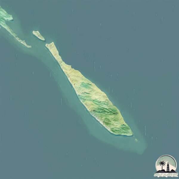
Geography and size of Dovhyi
Size: 3.689 km²
Coastline: 23.6 km
Ocean: Atlantic Ocean
Sea: Black Sea
Continent: Europe
Dovhyi is a Small Island spanning 3.7 km² with a coastline of 23.6 km.
Archipel: –
Tectonic Plate: Eurasia – One of the world’s largest tectonic plates, the Eurasian Plate covers a significant portion of Europe and Asia. It’s characterized by diverse geological features, including the Ural Mountains, the European Plain, and the Himalayas formed from its collision with the Indian Plate.
The geographic heart of the island is pinpointed at these coordinates:
Latitude: 46.39492664 / Longitude: 31.75166576
Climate and weather of Dovhyi
Climate Zone: Dry
Climate Details: Cold Semi-Arid (Steppe) Climate
Temperature: Cold
Climate Characteristics: Characterized by hot summers and cold winters, this climate is typically found on the edges of continental zones. It receives sufficient precipitation to avoid desert conditions.
Topography and nature of Dovhyi
Timezone: UTC+02:00
Timezone places: Europe/Mariehamn
Max. Elevation: -1 m
Mean Elevation: -1 m
Vegetation: Wetland
Tree Coverage: 84%
The mean elevation is -1 m. Remarkably, this unique island barely emerges above the sea level, showcasing nature’s fascinating interplay with the ocean. The island is characterized by Plains: Flat, low-lying lands characterized by a maximum elevation of up to 200 meters. On islands, plains are typically coastal lowlands or central flat areas.
Dominating Vegetation: Wetland
These areas are saturated with water, either permanently or seasonally, and support aquatic plants. Wetlands are important for biodiversity and water filtration. Dovhyi has a tree cover of 84 %.
Vegetation: 4 vegetation zones – Diverse Island
Four distinct vegetation zones mark these islands as ecologically diverse. They might feature varied landscapes such as forests, beaches, grasslands, and rocky areas. Such diversity reflects the island’s complex ecological interactions and varied habitats, which can support a rich array of wildlife and plant species.
Infrastructure and Travelling to Dovhyi
Does the island have a public airport? no.
There is no public and scheduled airport on Dovhyi. The nearest airport is Mykolaiv International Airport, located 73 km away.
Does the island have a major port? no.
There are no major ports on Dovhyi. The closest major port is DNIPRO-BUZKYY, approximately 38 km away.
The mean population of Dovhyi is 24 per km². Dovhyi is Gently Populated. The island belongs to Ukraine.
Continuing your journey, Danube Delta is the next notable island, situated merely km away.
Beautiful Islands From Flight ✈️ #shorts #turksandcaicos #caribbean #island #islands #unitedairlines


Ukraine is classified as Developing region: Regions characterized by lower income levels, with economies in the process of industrialization and modernization. The level of income is Lower middle income.
News – Latest Updates and Headlines from Dovhyi
Stay informed with the most recent news and important headlines from Dovhyi. Here’s a roundup of the latest developments.
Please note: The data used here has been primarily extracted from satellite readings. Deviations from exact values may occur, particularly regarding the height of elevations and population density. Land area and coastline measurements refer to average values at mean high tide.