Duladia
Welcome to Duladia, a Dry island in the Red Sea, part of the majestic Indian Ocean. This guide offers a comprehensive overview of what makes Duladia unique – from its geography and climate to its population, infrastructure, and beyond. Dive into the details:
- Geography and Size: Explore the island’s size and location.
- Climate and Weather: Weather patterns and temperature.
- Topography and Nature: Uncover the natural wonders of the island.
- Infrastructure and Travelling: Insights on reaching, staying, and making the most of your visit.
- News and Headlines: Latest News.
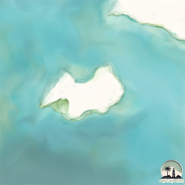
Geography and size of Duladia
Size: 12.1 km²
Coastline: 17.5 km
Ocean: Indian Ocean
Sea: Red Sea
Continent: Africa
Duladia is a Medium Island spanning 12 km² with a coastline of 18 km.
Archipel: Dahlak Archipelago – Located in the Red Sea near Eritrea, known for their historical significance, coral reefs, and diverse marine life.
Tectonic Plate: India – A major tectonic plate that initially moved northward at a rapid pace before colliding with the Eurasian Plate. This collision is responsible for the uplift of the Himalayas and the Tibetan Plateau.
The geographic heart of the island is pinpointed at these coordinates:
Latitude: 15.94733095 / Longitude: 40.04557586
Climate and weather of Duladia
Climate Zone: Dry
Climate Details: Hot Deserts Climate
Temperature: Hot
Climate Characteristics: Dominated by extremely hot temperatures, this climate is marked by minimal rainfall and barren landscapes. Nights often experience drastic temperature drops.
Topography and nature of Duladia
Timezone: UTC+03:00
Timezone places: Asia/Riyadh
Max. Elevation: 10 m
Mean Elevation: 3 m
Vegetation: Shrubland
Tree Coverage: 87%
The mean elevation is 3 m. The highest elevation on the island reaches approximately 10 meters above sea level. The island is characterized by Plains: Flat, low-lying lands characterized by a maximum elevation of up to 200 meters. On islands, plains are typically coastal lowlands or central flat areas.
Dominating Vegetation: Shrubland
Dominated by shrubs and small bushes, these areas are typical in dry, rocky, or sandy environments, as well as in regions with poor soil fertility. Duladia has a tree cover of 87 %.
Vegetation: 6 vegetation zones – Very Highly Diverse Island
Islands in this range are ecological powerhouses, showcasing a wide array of vegetation zones. Each zone, from lush rainforests to arid scrublands, coastal mangroves to mountainous regions, contributes to a complex and interdependent ecosystem. These islands are often hotspots of biodiversity, supporting numerous species and intricate ecological processes.
Infrastructure and Travelling to Duladia
Does the island have a public airport? no.
There is no public and scheduled airport on Duladia. The nearest airport is Massawa International Airport, located 78 km away.
Does the island have a major port? no.
There are no major ports on Duladia. The closest major port is MITSIWA HARBOR, approximately 71 km away.
The mean population of Duladia is 5 per km². Duladia is Gently Populated. The island belongs to Eritrea.
Continuing your journey, Mahun is the next notable island, situated merely km away.
I Visited Bangladesh's Secret Village 🇧🇩


Eritrea is classified as Least developed region: Countries that exhibit the lowest indicators of socioeconomic development, with the lowest Human Development Index ratings. The level of income is Low income.
News – Latest Updates and Headlines from Duladia
Stay informed with the most recent news and important headlines from Duladia. Here’s a roundup of the latest developments.
Please note: The data used here has been primarily extracted from satellite readings. Deviations from exact values may occur, particularly regarding the height of elevations and population density. Land area and coastline measurements refer to average values at mean high tide.