Welcome to Dunvert, a Tropical island in the Indian Ocean, part of the majestic Indian Ocean. This guide offers a comprehensive overview of what makes Dunvert unique – from its geography and climate to its population, infrastructure, and beyond. Dive into the details:
Geography and size of Dunvert
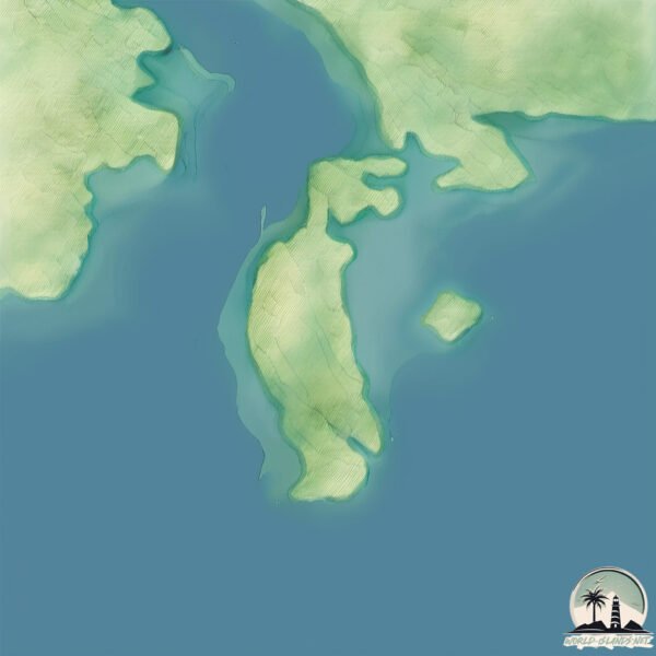
Size: 1.561 km²
Coastline: 8.6 km
Ocean: Indian Ocean
Sea: Indian Ocean
Continent: Oceania
Dunvert is a Small Island spanning 1.6 km² with a coastline of 8.6 km.
Archipel: –
Tectonic Plate: Australia – A major tectonic plate covering Australia, New Zealand, and parts of the Indian and Pacific Oceans, known for its relative stability and occasional seismic activity.
The geographic heart of the island is pinpointed at these coordinates:
Latitude: -16.28723458 / Longitude: 123.51677042
Climate and weather of Dunvert
Climate Zone: Tropical
Climate Details: Tropical Savanna, Wet
Temperature: Hot
Climate Characteristics: Defined by distinct wet and dry seasons with high temperatures year-round. Pronounced rainfall occurs during the wet season, while the dry season is marked by drought.
Topography and nature of Dunvert
Timezone: UTC+08:00
Timezone places: Australia/Perth
Max. Elevation: 24 m
Mean Elevation: 16 m
Vegetation: Herbaceous Cover
Tree Coverage: 67%
The mean elevation is 16 m. The highest elevation on the island reaches approximately 24 meters above sea level. The island is characterized by Plains: Flat, low-lying lands characterized by a maximum elevation of up to 200 meters. On islands, plains are typically coastal lowlands or central flat areas.
Dominating Vegetation: Herbaceous Cover
Comprising mainly of grasses, herbs, and ferns, these areas are common in prairies, meadows, and savannas, and can vary widely in species composition. Dunvert has a tree cover of 67 %.
Vegetation: 4 vegetation zones – Diverse Island
Four distinct vegetation zones mark these islands as ecologically diverse. They might feature varied landscapes such as forests, beaches, grasslands, and rocky areas. Such diversity reflects the island’s complex ecological interactions and varied habitats, which can support a rich array of wildlife and plant species.
Infrastructure and Travelling to Dunvert
Does the island have a public airport? no.
There is no public and scheduled airport on Dunvert. The nearest airport is Broome International Airport, located 233 km away.
Does the island have a major port? no.
There are no major ports on Dunvert. The closest major port is BROOME, approximately 234 km away.
The mean population of Dunvert is 0 per km². Dunvert is Uninhabited. The island belongs to Australia.
Continuing your journey, Hidden is the next notable island, situated merely km away.
Hidden Island Heaven You Won’t Believe 😱🌊
Description: Escape to a breathtaking island paradise ✨ Crystal-clear water, golden beaches, and peaceful vibes that feel like a ...Hidden Island Heaven You Won’t Believe 😱🌊
Description: Escape to a breathtaking island paradise ✨ Crystal-clear ...
Description: Escape to a breathtaking island paradise ✨ Crystal-clear water, golden beaches, and peaceful vibes that feel like a ...
This Hidden Island Looks Like Paradise 🌴
Discover one of the most beautiful places on Earth! This amazing ...
Discover one of the most beautiful places on Earth! This amazing island view shows the stunning beauty of nature with clear ...
Kimberley Adventure Trailer Sailing Derby to Hidden Island
Our Kimberley adventure starts at Derby with its claim to the 2nd ...
Our Kimberley adventure starts at Derby with its claim to the 2nd highest tides in the world. We juggle tides, rips and whirlpools to ...
Kimberley Highlights: Buccaneer Islands
The Buccaneer Archipelago is in the southern Kimberley region. This ...
The Buccaneer Archipelago is in the southern Kimberley region. This video explores Hidden Island, the Whirlpool Pass, Koolan ...
Kimberley Derby to Hidden Island Highlights #trailersailing #adventure #kimberley
Highlights of our Kimberley trip Derby to Hidden Island leg.
Highlights of our Kimberley trip Derby to Hidden Island leg.
Beyond the Oath: A Quiet Leader from a Hidden Island
A concise exploration of a president whose life before and after ...
A concise exploration of a president whose life before and after office reveals a leadership philosophy, crisis responses, and ...
A day in Hidden island #camping #travel #cooking
nature #hikingandcamping #hiking #travel #camping #usa #unitedstates ...
nature #hikingandcamping #hiking #travel #camping #usa #unitedstates #israel #iran #kuwait #saudiarabia #qutar #germany #uk ...
What This Camera Lens Revealed… A Hidden Island 😳 #shorts
A camera lens reveals something incredible. As the view moves out of ...
A camera lens reveals something incredible. As the view moves out of the lens, a hidden tropical island appears surrounded by ...
Exploring a Hidden Island by Small Plane — Aerial Adventure Begins ✈️🏝️
What better way to discover an island than from the sky? ✈️ In this ...
What better way to discover an island than from the sky? ✈️ In this short aerial journey, a small plane reveals breathtaking ...
How i rebuilt this hidden island(secret reveled)😱🤑 #ai #shorts #foryou #restoration
How i rebuilt this hidden island(secret reveled) #ai #shorts #foryou ...
How i rebuilt this hidden island(secret reveled) #ai #shorts #foryou #restoration This video is created using AI technology.
Massive Chaos in Hawaii Today! Giant Flooding Swept Away Many Homes, Cars in Manoa
The Hawaiian Islands are currently facing a monumental recovery effort ...
The Hawaiian Islands are currently facing a monumental recovery effort following a week of relentless, record-breaking rainfall ...
The Silent Gate of a Hidden Island
A voyage into a little-known mystery where a phantom island and ...
A voyage into a little-known mystery where a phantom island and vanished maps hint at a forgotten civilization. #MysteriousCoast ...
Untold Echoes of a Hidden Island
A fresh global mystery short series exploring little-known ...
A fresh global mystery short series exploring little-known destinations and secrets, each episode unveiling a new wonder. #Travel ...
This Hidden Island Will Blow Your Mind! 😱
shorts #island #hiddenisland #paradise #tropical #amazingplaces ...
shorts #island #hiddenisland #paradise #tropical #amazingplaces #travel #travelshorts #viral #mindblown #nature #shorts #ada ...
Africa 😑Twin Into Cobb Valley Dam
Unveiling the Cobalt Cradle: A Hidden Island Ceremony
A curious dive into a lesser-known coastal ritual that reveals how ...
A curious dive into a lesser-known coastal ritual that reveals how communities honor the sea with playful precision. #Culture ...
We explored a Hidden island
Ep 309 | Peanut Saves Us and Tows Us 160 Miles to Broome, Sailing Nutshell
After finally managing to make it through Whirlpool Pass we tuck into ...
After finally managing to make it through Whirlpool Pass we tuck into a bay at Dunvert island, just on the other side and have a ...
Whispers from a Hidden Island Wanderer
A deep dive into a remarkably elusive island rail, exploring its ...
A deep dive into a remarkably elusive island rail, exploring its remote mangrove habitat, nocturnal feeding, and quiet exchanges ...
Hidden Island Challenge Two YouTubers Compete for Ultimate Hideout
"Benvenuti su TheFutureVisionTube, il canale dedicato all'arte della ...
"Benvenuti su TheFutureVisionTube, il canale dedicato all'arte della previsione e all'esplorazione delle strade non battute del ...
This Place Felt Like A Painting 😳 #lofotenislands
Those who know me or watch our Instagram stories know that I love ...
Those who know me or watch our Instagram stories know that I love capturing a place through its colors. There's something ...
Whispers of a Hidden Island Mystery
A gripping true crime short exploring a little-known shipwreck ...
A gripping true crime short exploring a little-known shipwreck hideaway and the eerie clues it left behind. #TreasureHunt ...
12 Places That Solidify Gran as Contender for "World’s Best Island"
One of the rarest types of islands in the world, known as the "Mini ...
One of the rarest types of islands in the world, known as the "Mini Continent," Gran Canaria has one of the densest diversities of ...
Climbing To The Island In The Sky // A Solo Ascent to Summit UN 5848
A couple years ago I did a quick video of a red ridge (Gordon's Ridge) ...
A couple years ago I did a quick video of a red ridge (Gordon's Ridge) just north of Sky Island. I then tried to summit UN 5848.
The Complete Laugavegur & Fimmvörðuháls Hiking Guide | 6 Days Across Iceland’s Wildest Landscapes
Iceland's two most iconic trails — Laugavegur and Fimmvörðuháls — ...
Iceland's two most iconic trails — Laugavegur and Fimmvörðuháls — combined into one unforgettable 6-day adventure. This is ...
Australia is classified as Developed region: nonG7: Developed economies outside of the Group of Seven, characterized by high income and advanced economic structures. The level of income is High income: OECD.
News – Latest Updates and Headlines from Dunvert
Stay informed with the most recent news and important headlines from Dunvert. Here’s a roundup of the latest developments.
Loading...
Please note: The data used here has been primarily extracted from satellite readings. Deviations from exact values may occur, particularly regarding the height of elevations and population density. Land area and coastline measurements refer to average values at mean high tide.