Welcome to East Island, a Tropical island in the Andaman or Burma Sea, part of the majestic Indian Ocean. This guide offers a comprehensive overview of what makes East Island unique – from its geography and climate to its population, infrastructure, and beyond. Dive into the details:
Geography and size of East Island
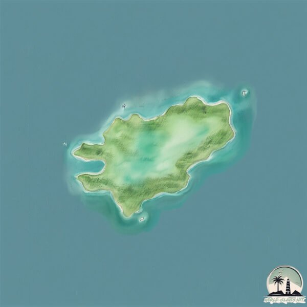
Size: 4.419 km²
Coastline: 12.8 km
Ocean: Indian Ocean
Sea: Andaman or Burma Sea
Continent: Seven seas (open ocean)
East Island is a Small Island spanning 4.4 km² with a coastline of 12.8 km.
Archipel: Andaman Islands – Situated in the Bay of Bengal, the Andaman Islands are part of the Indian territory and are known for their picturesque beaches, clear waters, and lush forests. These islands are home to a variety of indigenous tribes and have a rich biodiversity, including unique flora and fauna. The Andamans also have a significant history, notably during the British colonial period.
Tectonic Plate: Burma – Also known as the Burma Plate, it’s a minor tectonic plate in Southeast Asia, largely covering Burma (Myanmar) and parts of the Indian Ocean. It’s involved in the subduction process under the Eurasian Plate, contributing to seismic activity in the region.
The geographic heart of the island is pinpointed at these coordinates:
Latitude: 13.64056935 / Longitude: 93.05255899
Climate and weather of East Island
Climate Zone: Tropical
Climate Details: Tropical Monsoon Climate
Temperature: Hot
Climate Characteristics: Characterized by heavy rainfall, high humidity, and uniformly high temperatures, but with a distinct short dry season. It features a seasonal reversal of prevailing wind directions.
Topography and nature of East Island
Timezone: UTC+05:30
Timezone places:
Max. Elevation: 23 m
Mean Elevation: 13 m
Vegetation: Evergreen Broadleaf Forest
Tree Coverage: 60%
The mean elevation is 13 m. The highest elevation on the island reaches approximately 23 meters above sea level. The island is characterized by Plains: Flat, low-lying lands characterized by a maximum elevation of up to 200 meters. On islands, plains are typically coastal lowlands or central flat areas.
Dominating Vegetation: Evergreen Broadleaf Forest
Characterized by dense, lush canopies of broadleaf trees that retain their leaves year-round. These forests are typically found in tropical and subtropical regions and are known for their high biodiversity. East Island has a tree cover of 60 %.
Vegetation: 9 vegetation zones – Very Highly Diverse Island
Islands in this range are ecological powerhouses, showcasing a wide array of vegetation zones. Each zone, from lush rainforests to arid scrublands, coastal mangroves to mountainous regions, contributes to a complex and interdependent ecosystem. These islands are often hotspots of biodiversity, supporting numerous species and intricate ecological processes.
Infrastructure and Travelling to East Island
Does the island have a public airport? no.
There is no public and scheduled airport on East Island. The nearest airport is Veer Savarkar International Airport / INS Utkrosh, located 223 km away.
Does the island have a major port? no.
There are no major ports on East Island. The closest major port is PORT BLAIR, approximately 218 km away.
The mean population of East Island is 31 per km². East Island is Gently Populated. The island belongs to India.
Continuing your journey, Landfall Island is the next notable island, situated merely km away.
The Mysteries of the Moai on Easter Island | National Geographic
A Polynesian society blossomed in this unlikely locale after hardy souls somehow navigated a fleet of wooden outrigger canoes to ...The Mysteries of the Moai on Easter Island | National Geographic
A Polynesian society blossomed in this unlikely locale after hardy ...
A Polynesian society blossomed in this unlikely locale after hardy souls somehow navigated a fleet of wooden outrigger canoes to ...
Scientists Finally Discovered The Truth About Easter Island #Shorts
Scientists Finally Discovered The Truth About Easter Island #Shorts.
Scientists Finally Discovered The Truth About Easter Island #Shorts.
This Tribe Will Kill You If You Step On Their Island #travel #shorts #island
What do you think of this mysterious island? Remember to subscribe and ...
What do you think of this mysterious island? Remember to subscribe and share, thanks for watching. Welcome to the mysterious ...
What is EASTER ISLAND Really Like? 🇨🇱 (not what we expected)
Easter Island, Rapa Nui, Isla de Pascua - whatever you call it, this ...
Easter Island, Rapa Nui, Isla de Pascua - whatever you call it, this place is one of a kind. In this travel vlog we fly from Santiago, ...
What so special about Chile & Easter Island?!
This is why Easter Island is so special #easterislandheads ...
This is why Easter Island is so special #easterislandheads #easterislandhead #easterislandinthesun #easterislandstatue ...
Ancient Aliens: Uncovering the TRUTH of Easter Island | History
Who really created the Easter Island monoliths? See more in this ...
Who really created the Easter Island monoliths? See more in this compilation from Ancient Aliens. New Season Fri., Feb. 7 at 9/8c; ...
The moai concept 💀#vairal #trending #shorts
moment before disaster troll face troll face edit #trollface ...
moment before disaster troll face troll face edit #trollface #trollfaceedit #troll #edit #meme #trending #shorts #shortsfeed ...
What Happened to the People of Easter Island? #foryoupage #fyp #podcast #joerogan #easterisland
What Happened to the People of Easter Island?
What Happened to the People of Easter Island?
These Statues Have Hidden Bodies 🗿😱 (Moai)
Where Did the Easter Island Statues Come from? | BBC Earth
Sir David Attenborough looked into the history of the statues on the ...
Sir David Attenborough looked into the history of the statues on the remote Easter Island to discover how these astonishing ...
The Famous Easter Island Heads Have Hidden Bodies #easterisland #rapanui #ancienthistory #ancient
The Strange Finding About The Moai Statues in Easter Island
The Mystery of Easter Island
6. Easter Island - Where Giants Walked
SUPPORT THE SHOW AND WATCH AD-FREE: ...
Eastern Island
Provided to YouTube by TuneCore Japan Eastern Island · PiANO MASTER ...
Provided to YouTube by TuneCore Japan Eastern Island · PiANO MASTER Beautiful Forest ℗ 2019 FARM RECORDS Released ...
INO REGENERATION - EAST ISLAND (SOBA STUDIO JAMMING)
enjoy rice field jamming ino as vox joe dwal as guitar audio & video ...
enjoy rice field jamming ino as vox joe dwal as guitar audio & video graycesoba.
This is the World's Most Remote Island..
The World's Most Remote Islands are the Pitcairn Islands located in ...
The World's Most Remote Islands are the Pitcairn Islands located in the south pacific ocean. The town here is known as ...
Life On The Most Remote Island In The World
I visited the Most Remote Town on the Most Remote Island in the world: ...
I visited the Most Remote Town on the Most Remote Island in the world: Hanga Roa, Easter Island ▻ Download Airalo free today, ...
Christmas on Easter Island
Provided to YouTube by Cherry Red Records Christmas on Easter Island · ...
Provided to YouTube by Cherry Red Records Christmas on Easter Island · Sad Lovers & Giants Treehouse Poetry ℗ 2017 Cherry ...
New Change in the Map - 05: East Island Got Destroyed
Hey, natural disasters count, right? ➤ Support this channel with my ...
How the Civilization On Easter Island Collapsed
Easter Island is a Chilean island located in the southeastern Pacific ...
Easter Island is a Chilean island located in the southeastern Pacific Ocean. It's most widely known for the incredible stone statues ...
Mysterious Moai: The Giant Heads of Easter Island for Kids - FreeSchool
They are famous around the world: giant stone heads on Easter Island. ...
They are famous around the world: giant stone heads on Easter Island. Easter Island, also known as Rapa Nui, is an isolated ...
A New Easter Island Conspiracy?
EASTER ISLAND | ULTIMATE TRAVEL GUIDE | SOUTH AMERICA
Easter Island is a spectacular place that has so much to offer, which ...
Easter Island is a spectacular place that has so much to offer, which is why we put together this Travel Guide. To make sure you ...
9 Days on Easter Island Itinerary | Easter Island and Rapa Nui Travel
This is our incredible 9 day itinerary of Easter Island that walks you ...
This is our incredible 9 day itinerary of Easter Island that walks you through how you could plan a trip just like this that is just about ...
India is classified as Emerging region: BRIC: Brazil, Russia, India, and China – Economies noted for their rapid growth and increasing influence on global affairs. The level of income is Lower middle income.
News – Latest Updates and Headlines from East Island
Stay informed with the most recent news and important headlines from East Island. Here’s a roundup of the latest developments.
Loading...
Please note: The data used here has been primarily extracted from satellite readings. Deviations from exact values may occur, particularly regarding the height of elevations and population density. Land area and coastline measurements refer to average values at mean high tide.