Welcome to Entrada, a Polar island in the South Pacific Ocean, part of the majestic Pacific Ocean. This guide offers a comprehensive overview of what makes Entrada unique – from its geography and climate to its population, infrastructure, and beyond. Dive into the details:
Geography and size of Entrada
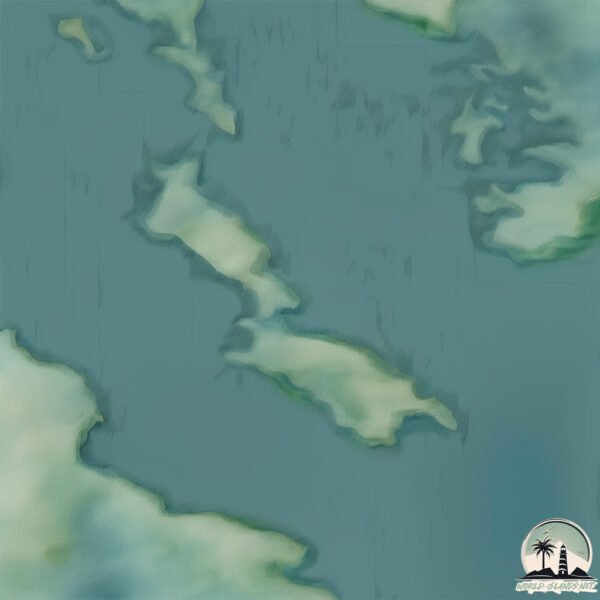
Size: 1.216 km²
Coastline: 10.3 km
Ocean: Pacific Ocean
Sea: South Pacific Ocean
Continent: South America
Entrada is a Small Island spanning 1.2 km² with a coastline of 10.3 km.
Archipel: –
Tectonic Plate: South America – A major plate covering the South American continent and part of the Atlantic Ocean, known for the Andes mountain range and significant seismic and volcanic activity.
The geographic heart of the island is pinpointed at these coordinates:
Latitude: -51.26151871 / Longitude: -74.44564704
Climate and weather of Entrada
Climate Zone: Polar
Climate Details: Tundra
Temperature: Cold
Climate Characteristics: The tundra climate features long, extremely cold winters and short, cool summers. Vegetation is limited to mosses, lichens, and small shrubs due to the low temperatures and short growing seasons. Biodiversity is low, but some specialized species thrive.
Topography and nature of Entrada
Timezone: UTC-04:00
Timezone places: America/La_Paz
Max. Elevation: 12 m
Mean Elevation: 10 m
Vegetation: Herbaceous Cover
Tree Coverage: 51%
The mean elevation is 10 m. The highest elevation on the island reaches approximately 12 meters above sea level. The island is characterized by Plains: Flat, low-lying lands characterized by a maximum elevation of up to 200 meters. On islands, plains are typically coastal lowlands or central flat areas.
Dominating Vegetation: Herbaceous Cover
Comprising mainly of grasses, herbs, and ferns, these areas are common in prairies, meadows, and savannas, and can vary widely in species composition. Entrada has a tree cover of 51 %.
Vegetation: 3 vegetation zones – Moderately Diverse Island
These islands start to show a broader range of ecological niches. With three vegetation zones, they may offer a mix of ecosystems like coastal areas, inland woods, and perhaps a distinct wetland or dry area. This diversity supports a wider range of flora and fauna, making these islands more ecologically complex than those with minimal diversity.
Infrastructure and Travelling to Entrada
Does the island have a public airport? no.
There is no public and scheduled airport on Entrada. The nearest airport is Lieutenant Julio Gallardo Airport, located 216 km away.
Does the island have a major port? no.
There are no major ports on Entrada. The closest major port is PUERTO NATALES, approximately 213 km away.
The mean population of Entrada is 1 per km². Entrada is Uninhabited. The island belongs to Chile.
Continuing your journey, Soffia is the next notable island, situated merely km away.
Entry Island
Miscellaneous images of Entry Island on a sunny day.Entry Island
Miscellaneous images of Entry Island on a sunny day.
Miscellaneous images of Entry Island on a sunny day.
3 Things to Know BEFORE Going to Universal Studios 😮🌎 (First Visit Tips)
Before your first visit to Universal Studios, here are 3 things you ...
Before your first visit to Universal Studios, here are 3 things you should know! These are 3 things I wish I knew before going to ...
How to Design Your Island Entrance in ACNH!! // 15 Ideas
As always, please remember to check out the brilliant creators ...
As always, please remember to check out the brilliant creators featured in today's video 😀 Also, sorry if my voice is deeper than ...
Jinwoo's Entry On Jeju Island ❤️🔥 || Aura Of Sung Jin Woo At This Moment #sololeveling #sungjinwoo
Jinwoo's Entry On Jeju Island ❤️ || Aura Of Sung Jin Woo At This ...
Jinwoo's Entry On Jeju Island ❤️ || Aura Of Sung Jin Woo At This Moment #sololeveling #sungjinwoo.
Cómo comprar tu entrada On-Line para Island Of Adventure
Conoce en este Tutorial cómo comprar On-Line tu entrada para visitar ...
Conoce en este Tutorial cómo comprar On-Line tu entrada para visitar el parque de Island of Adventure de Universal en Orlando, ...
Entrada Island of Adventure, Universal Studios Orlando
Testando as Melhores Estratégias na Entrada Antecipada do Universal Islands of Adventure
Compre seu ingresso ou hospedagem em Orlando com o Foco no Roteiro e ...
Compre seu ingresso ou hospedagem em Orlando com o Foco no Roteiro e GANHE a minha assessoria para toda a sua viagem ...
entrada island of adventires
island.
island.
Japanese Island Entrance 🌿 (speed build) // Animal Crossing
Today, we're going to build a Japanese Island Entrance ...
Today, we're going to build a Japanese Island Entrance .................................................................................... « Become A Member ...
La bonita entrada de Island of adventure #fun #harrypotter #universalorlando #universalstudios
Japanese island entrance ❄️ Animal Crossing New Horizons // Speed Build
Today, we're going to build a Japanese island entrance ❄️ Animal ...
Today, we're going to build a Japanese island entrance ❄️ Animal Crossing New Horizons. 00:00 Intro 00:08 I'm back with a ...
opening ( entrada ) de pirate island entra en el juego
este es el opening ( la entrada , o el principio ) de la serie pirate ...
este es el opening ( la entrada , o el principio ) de la serie pirate island.
Entrada a Banana Island en Qatar 2022
Why nobody is allowed on Plum island 🏝️#newyork #plumisland #island
SKULL ISLAND REIGN of KONG at Universal’s Islands of Adventure #islandsofadventure #skullisland
Watch BEFORE Bringing a Backpack to EPIC UNIVERSE! 😮🎒(Universal Packing & Ride Tips)
These are 3 things you should know BEFORE you pack a park bag for ...
These are 3 things you should know BEFORE you pack a park bag for Universal's Epic Universe! Epic Universe is a brand new ...
Swampcore Island Entrance 🌿 #animalcrossing #あつ森 #acnh
Today, we're going to build a Swampcore Island Entrance ...
Today, we're going to build a Swampcore Island Entrance ................................................................................... « Become A Member ...
Islands of Adventure HD - Entry - Orlando Resorts Universal Studios - Entrada Parks Florida
Islands of Adventure HD - Entry - Orlando Resorts Universal Studios - ...
Islands of Adventure HD - Entry - Orlando Resorts Universal Studios - Entrada Islands of Adventure Agora temos blog! Acessem: ...
Universal Island of Afventure - Orlando - Entrada
Entrando no Universal Studios em Orlando.
Entrando no Universal Studios em Orlando.
Entrada temprana a Islands of Adventure en Universal Orlando | Early Park Admission
En este vlog Jimmy y Meli muestran los beneficios de la entrada ...
En este vlog Jimmy y Meli muestran los beneficios de la entrada temprana, o en ingles Early Park Admission, al parque Islands of ...
Running across empty island - Switch 1 vs Switch 2 #animalcrossingnewhorizons #animalcrossing #acnh
WHY ARE PREPPY HOUSES SO EXPENSIVE! 😭
also try guys for joining and buying my outfits it rlly helps me ...
also try guys for joining and buying my outfits it rlly helps me finish my build! #roblox #adoptme #adoptmegame #preppy ...
Snoop Dogg and Kevin Hart React To The Island Boys😂
If you enjoyed this video, please consider subscribing to our channel ...
If you enjoyed this video, please consider subscribing to our channel for more content like this. At Zenith Lab, our mission is to add ...
Island Neighborhoods around the World / Ilha do Príncipe 🏝️ Entrada de Vitória ES
ELLIS ISLAND, la puerta de entrada al sueño americano
Chile is classified as Emerging region: G20: Group of Twenty – Major economies comprising both developed and emerging countries, representing the world’s largest economies. The level of income is Upper middle income.
News – Latest Updates and Headlines from Entrada
Stay informed with the most recent news and important headlines from Entrada. Here’s a roundup of the latest developments.
Loading...
Please note: The data used here has been primarily extracted from satellite readings. Deviations from exact values may occur, particularly regarding the height of elevations and population density. Land area and coastline measurements refer to average values at mean high tide.