Espiritu Santo
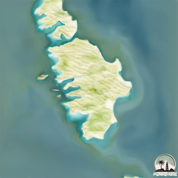
Welcome to Espiritu Santo, a Dry island in the Gulf of California, part of the majestic Pacific Ocean. This guide offers a comprehensive overview of what makes Espiritu Santo unique – from its geography and climate to its population, infrastructure, and beyond. Dive into the details:
- Geography and Size: Explore the island’s size and location.
- Climate and Weather: Weather patterns and temperature.
- Topography and Nature: Uncover the natural wonders of the island.
- Infrastructure and Travelling: Insights on reaching, staying, and making the most of your visit.
- News and Headlines: Latest News.
Geography and size of Espiritu Santo
Size: 85 km²
Coastline: 72.3 km
Ocean: Pacific Ocean
Sea: Gulf of California
Continent: North America
Espiritu Santo is a Medium Island spanning 85 km² with a coastline of 72 km.
Archipel: –
Tectonic Plate: Pacific – The world’s largest tectonic plate, covering much of the Pacific Ocean, known for the Pacific Ring of Fire with extensive seismic and volcanic activity.
The geographic heart of the island is pinpointed at these coordinates:
Latitude: 24.47329889 / Longitude: -110.34275038
Climate and weather of Espiritu Santo
Climate Zone: Dry
Climate Details: Hot Deserts Climate
Temperature: Hot
Climate Characteristics: Dominated by extremely hot temperatures, this climate is marked by minimal rainfall and barren landscapes. Nights often experience drastic temperature drops.
Topography and nature of Espiritu Santo
Timezone: UTC-07:00
Timezone places: America/Denver
Max. Elevation: 471 m
Mean Elevation: 126 m
Vegetation: Shrubland
Tree Coverage: 15%
The mean elevation is 126 m. The highest elevation on the island reaches approximately 471 meters above sea level. The island is characterized by Hills: Gently sloping landforms with rounded tops, having a maximum elevation between 200 and 500 meters. Hills contribute to a varied landscape on islands.
Dominating Vegetation: Shrubland
Dominated by shrubs and small bushes, these areas are typical in dry, rocky, or sandy environments, as well as in regions with poor soil fertility. Espiritu Santo has a tree cover of 15 %.
Vegetation: 11 vegetation zones – Exceptionally Diverse Island
Islands with more than ten vegetation zones are among the most ecologically rich and varied in the world. These islands are akin to miniature continents, boasting an incredible array of ecosystems. The sheer range of habitats, from high peaks to deep valleys, rainforests to deserts, creates a mosaic of life that is unparalleled. They are crucial for conservation and ecological studies.
Infrastructure and Travelling to Espiritu Santo
Does the island have a public airport? no.
There is no public and scheduled airport on Espiritu Santo. The nearest airport is Manuel Márquez de León International Airport, located 37 km away.
Does the island have a major port? no.
There are no major ports on Espiritu Santo. The closest major port is PICHILINGUE, approximately 15 km away.
The mean population of Espiritu Santo is 0 per km². Espiritu Santo is Uninhabited. The island belongs to Mexico.
Continuing your journey, Partida is the next notable island, situated merely km away.
How to visit the beautiful Isla Espiritu Santo in La Paz Mexico


Mexico is classified as Emerging region: MIKT: Mexico, Indonesia, South Korea, and Turkey – Economies recognized for their development potential and emerging market status. The level of income is Upper middle income.
News – Latest Updates and Headlines from Espiritu Santo
Stay informed with the most recent news and important headlines from Espiritu Santo. Here’s a roundup of the latest developments.
Please note: The data used here has been primarily extracted from satellite readings. Deviations from exact values may occur, particularly regarding the height of elevations and population density. Land area and coastline measurements refer to average values at mean high tide.