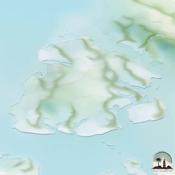
Welcome to Esther, a Continental island in the Gulf of Alaska, part of the majestic Pacific Ocean. This guide offers a comprehensive overview of what makes Esther unique – from its geography and climate to its population, infrastructure, and beyond. Dive into the details:
Geography and size of Esther
Size: 132.6 km²
Coastline: 154.3 km
Ocean: Pacific Ocean
Sea: Gulf of Alaska
Continent: North America
Esther is a Large Island spanning 133 km² with a coastline of 154 km.
Archipel: –
Tectonic Plate: Somalia – A large tectonic plate covering the Horn of Africa and parts of the Indian Ocean, known for the East African Rift where it’s splitting away from the African Plate.
The geographic heart of the island is pinpointed at these coordinates:
Latitude: 60.84973939 / Longitude: -148.03580277
Climate and weather of Esther
Climate Zone: Continental
Climate Details: Subarctic Climate
Temperature: Cold Summer
Climate Characteristics: Characterized by long, extremely cold winters and short, cool summers, often found in northern latitudes of North America and Eurasia.
Topography and nature of Esther
Timezone: UTC-09:00
Timezone places: America/Anchorage
Max. Elevation: 654 m
Mean Elevation: 219 m
Vegetation: Open Woodland
Tree Coverage: 69%
The mean elevation is 219 m. The highest elevation on the island reaches approximately 654 meters above sea level. The island is characterized by Plateau: Elevated flatlands rising sharply above the surrounding area, with a maximum elevation over 500 meters but a mean elevation less than 300 meters, forming unique highland areas on islands.
Dominating Vegetation: Open Woodland
Characterized by sparsely distributed trees with open canopy allowing sunlight to penetrate, supporting grasses and shrubs underneath. Often found in drier or transitional environments. Esther has a tree cover of 69 %.
Vegetation: 10 vegetation zones – Very Highly Diverse Island
Islands in this range are ecological powerhouses, showcasing a wide array of vegetation zones. Each zone, from lush rainforests to arid scrublands, coastal mangroves to mountainous regions, contributes to a complex and interdependent ecosystem. These islands are often hotspots of biodiversity, supporting numerous species and intricate ecological processes.
Infrastructure and Travelling to Esther
Does the island have a public airport? no.
There is no public and scheduled airport on Esther. The nearest airport is Tatitlek Airport, located 136 km away.
Does the island have a major port? no.
There are no major ports on Esther. The closest major port is WHITTIER, approximately 57 km away.
The mean population of Esther is 0 per km². Esther is Uninhabited. The island belongs to United States of America.
Continuing your journey, Culross is the next notable island, situated merely km away.
How the Civilization On Easter Island Collapsed
Easter Island is a Chilean island located in the southeastern Pacific Ocean. It's most widely known for the incredible stone statues ...How the Civilization On Easter Island Collapsed
Easter Island is a Chilean island located in the southeastern Pacific ...
Easter Island is a Chilean island located in the southeastern Pacific Ocean. It's most widely known for the incredible stone statues ...
Ancient Aliens: Uncovering the TRUTH of Easter Island | History
Who really created the Easter Island monoliths? See more in this ...
Who really created the Easter Island monoliths? See more in this compilation from Ancient Aliens. New Season Fri., Feb. 7 at 9/8c; ...
What Happened to the People of Easter Island? #foryoupage #fyp #podcast #joerogan #easterisland
What Happened to the People of Easter Island?
What Happened to the People of Easter Island?
The Famous Easter Island Heads Have Hidden Bodies #easterisland #rapanui #ancienthistory #ancient
Scientists Finally Discovered The Truth About Easter Island #Shorts
Scientists Finally Discovered The Truth About Easter Island #Shorts.
Scientists Finally Discovered The Truth About Easter Island #Shorts.
Where Did the Easter Island Statues Come from? | BBC Earth
Sir David Attenborough looked into the history of the statues on the ...
Sir David Attenborough looked into the history of the statues on the remote Easter Island to discover how these astonishing ...
Secrets of Easter Island REVEALED | History's Greatest Mysteries (S3)
This island is unlike anything they've ever seen. See more in this ...
This island is unlike anything they've ever seen. See more in this scene from Season 3, Episode 19, "The Secrets of Easter Island.
The Mysteries of the Moai on Easter Island | National Geographic
A Polynesian society blossomed in this unlikely locale after hardy ...
A Polynesian society blossomed in this unlikely locale after hardy souls somehow navigated a fleet of wooden outrigger canoes to ...
Scientists FINALLY Discovered the TRUTH About Easter Island
Welcome to our YouTube video on the mysteries of Easter Island! In ...
Welcome to our YouTube video on the mysteries of Easter Island! In this captivating exploration, we delve deep into the enigmatic ...
Easter Island - Mysteries of a Lost World (BBC)
BBC documentary. The contrast between the majestic statues of Easter ...
BBC documentary. The contrast between the majestic statues of Easter Island and the desolation of their surroundings is stark.
Easter Island's Origin: What Secrets Lie Beneath the Surface? #mystery #history #ancient #joerogan
Join Graham Hancock as he delves into the enigmatic origins of Easter ...
Join Graham Hancock as he delves into the enigmatic origins of Easter Island's culture with Joe Rogan. In this captivating ...
9 Days on Easter Island Itinerary | Easter Island and Rapa Nui Travel
This is our incredible 9 day itinerary of Easter Island that walks you ...
This is our incredible 9 day itinerary of Easter Island that walks you through how you could plan a trip just like this that is just about ...
Esther Island Fly Out with 9DT
Esther Island trip from Lake Hood.
Esther Island trip from Lake Hood.
These Statues Have Hidden Bodies 🗿😱 (Moai)
Mysterious Moai: The Giant Heads of Easter Island for Kids - FreeSchool
They are famous around the world: giant stone heads on Easter Island. ...
They are famous around the world: giant stone heads on Easter Island. Easter Island, also known as Rapa Nui, is an isolated ...
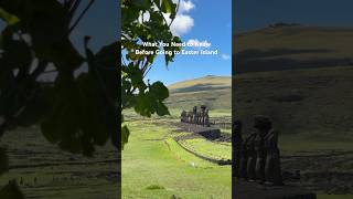
What You Need to Know Before Going to Easter Island
What You Need to Know Before Going to Easter Island.
What You Need to Know Before Going to Easter Island.
Ancient Aliens: The Easter Island Mystery (Season 13) | History
Stay up to date on all of HISTORY's latest premieres at ...
The Mystery of Easter Island
ESTHER ISLAND PHOTOSLIDE 09'
Easter Island moai 'walked'
Researchers have used a replica moai to show how the giant statues may ...
Researchers have used a replica moai to show how the giant statues may have been "walked" to where they are displayed.
Americans React To Jeffrey Epstein Rejecting Black Girls On His Island
epsteinfiles #jeffreyepstein.
epsteinfiles #jeffreyepstein.
Esther's Island by Davy Clincart
Esther's Island - Short story and music soundtrack by Davy Clincart. ...
Esther's Island - Short story and music soundtrack by Davy Clincart. The tale of Esther and Charlie who find love later in life, only ...
The mysterious statues of Easter Island
How the Easter Island Heads Walked #shorts
United States of America is classified as Developed region: G7: Group of Seven – Major advanced economies, including Canada, France, Germany, Italy, Japan, the United Kingdom, and the United States. The level of income is High income: OECD.
News – Latest Updates and Headlines from Esther
Stay informed with the most recent news and important headlines from Esther. Here’s a roundup of the latest developments.
Loading...
Please note: The data used here has been primarily extracted from satellite readings. Deviations from exact values may occur, particularly regarding the height of elevations and population density. Land area and coastline measurements refer to average values at mean high tide.