Welcome to Farasan, a Dry island in the Red Sea, part of the majestic Indian Ocean. This guide offers a comprehensive overview of what makes Farasan unique – from its geography and climate to its population, infrastructure, and beyond. Dive into the details:
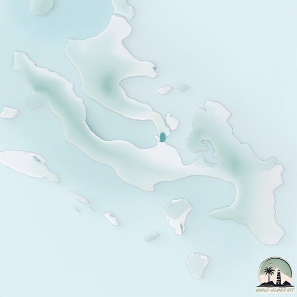
Geography and size of Farasan
Size: 396.7 km²
Coastline: 220.8 km
Ocean: Indian Ocean
Sea: Red Sea
Continent: Asia
Farasan is a Large Island spanning 397 km² with a coastline of 221 km.
Archipel: –
Tectonic Plate: Arabia – A major tectonic plate covering the Arabian Peninsula and parts of the Middle East. The plate is primarily continental and known for its collision with the Eurasian Plate, leading to the uplift of the Zagros Mountains.
The geographic heart of the island is pinpointed at these coordinates:
Latitude: 16.72962584 / Longitude: 42.01069666
Climate and weather of Farasan
Climate Zone: Dry
Climate Details: Hot Deserts Climate
Temperature: Hot
Climate Characteristics: Dominated by extremely hot temperatures, this climate is marked by minimal rainfall and barren landscapes. Nights often experience drastic temperature drops.
Topography and nature of Farasan
Timezone: UTC+03:00
Timezone places: Asia/Riyadh
Max. Elevation: 40 m
Mean Elevation: 12 m
Vegetation: Rocky Terrain
Tree Coverage: 0%
The mean elevation is 12 m. The highest elevation on the island reaches approximately 40 meters above sea level. The island is characterized by Plains: Flat, low-lying lands characterized by a maximum elevation of up to 200 meters. On islands, plains are typically coastal lowlands or central flat areas.
Dominating Vegetation: Rocky Terrain
Landscapes dominated by gravel, rock, and stone, with little to no vegetation. These areas are often found in mountainous regions or deserts. Farasan has a tree cover of 0 %.
Vegetation: 5 vegetation zones – Highly Diverse Island
With five different vegetation zones, these islands offer a rich tapestry of ecosystems. The variety could include dense forests, open meadows, wetlands, coastal zones, and more. This level of diversity supports an intricate web of life, with each zone playing a vital role in the overall ecological health and balance of the island.
Infrastructure and Travelling to Farasan
Does the island have a public airport? no.
There is no public and scheduled airport on Farasan. The nearest airport is Jizan Regional Airport / King Abdullah bin Abdulaziz Airport, located 49 km away.
Does the island have a major port? no.
There are no major ports on Farasan. The closest major port is JIZAN, approximately 39 km away.
The mean population of Farasan is 28 per km². Farasan is Gently Populated. The island belongs to Saudi Arabia.
Continuing your journey, Qummah is the next notable island, situated merely km away.
Farasan Islands: Saudi Arabia’s little-known gem
The #Farasan Archipelago, known for its #picturesque scenery, is an undiscovered gem expected to become one of #Saudi ...Farasan Islands: Saudi Arabia’s little-known gem
The #Farasan Archipelago, known for its #picturesque scenery, is an ...
The #Farasan Archipelago, known for its #picturesque scenery, is an undiscovered gem expected to become one of #Saudi ...
We Explored the Farasan Islands - the Maldives of Saudi Arabia? (Jazan Region)
Arabic subtitles are available - الترجمة بالعربية متوفرة ايضا. يرجى ...
Arabic subtitles are available - الترجمة بالعربية متوفرة ايضا. يرجى اختيارها من الاعدادات In this video of Living the Jo Life, we go ...
Farasan Island Saudi Arabia Best Places to Visit
This video describes the 12 best places to visit and tourist ...
This video describes the 12 best places to visit and tourist attractions in Farasan Island, Saudi Arabia. It includes Ghadeer Bay ...
Trip To Jizan || Farasan Island||1st time Ship Trip|| Jeddah to JizanTrip||Vlog#1
Assalamualekum to everyone Aaj ka vlog tour vlog hai , Jeddah to Jizan ...
Assalamualekum to everyone Aaj ka vlog tour vlog hai , Jeddah to Jizan tour vlog hai Inshaa Allah aap logo ko passnd ayega it's ...
Trip to Farasan Island, Jazan Saudi Arabia
Farasan island is situated in southern province of Saudi Arabia. It's ...
Farasan island is situated in southern province of Saudi Arabia. It's also called the Maldives of Saudia Arabia. Join us as we ...
Farasan Island - Saudi Arabia
Here's an itinerary for a 3-night trip to Farasan Island in Saudi ...
Here's an itinerary for a 3-night trip to Farasan Island in Saudi Arabia, starting from Jizan: Day 1: - Arrive in Jizan and spend the ...
Extreme Hospitality!! SAUDI ARABIAN FOOD on Remote Farasan Islands in the RED SEA!!
Farasan island saudi arabia/Farasan island/Farasan island jazan saudi/trip to farasan/جزيرة فرسان
farasan island #ksa #shortvideo #short #beautiful beach #blue water ...
farasan island #ksa #shortvideo #short #beautiful beach #blue water thanks for your love n support for my channel..please keep ...
Exploring Farasan Island: Culture, Food & Coastal Beauty
A Trip to Farasan Island: Hidden Treasures, Traditional Dishes & Rich ...
A Trip to Farasan Island: Hidden Treasures, Traditional Dishes & Rich Heritage Discover the Hidden Gems of Farasan ...
Spending 24 hours Alone on an Island in Saudi Arabia 🇸🇦
Farsan Island 🏝️ The Paradise, Camping 🏕️ Challenge, Jazan to Fursan ...
Farsan Island 🏝️ The Paradise, Camping 🏕️ Challenge, Jazan to Fursan Saudi ARABIA Watch Latest Vlogs: Ashab al ...
Al Farasan Island, Jizan Saudi Arabia June 2025
Farsan Island🏝️|| Jazan ||SaudiArabia#shortvideos #youtubeshorts
OTTOMAN CASTLE | QAL'AT AL ATRAK | HISTORICAL SITE OF FARASAN ISLAND
A great attraction for history enthusiasts, Ottoman Castle, also ...
A great attraction for history enthusiasts, Ottoman Castle, also called Qal'at al-Atrak, is situated in Farasan Island. Perched at an ...
No one’s heard of these islands
These are the Red Sea islands no one ever told you about. Even more ...
These are the Red Sea islands no one ever told you about. Even more surprising? They belong to a country the world usually ...
24 Hours on Saudi's TROPICAL ISLANDS 🏝️🇸🇦 (Rare Mangrove Forests)
Going to therapy is a sign of strength, not weakness. My paid partner ...
Going to therapy is a sign of strength, not weakness. My paid partner BetterHelp makes therapy simple, with 10% off your first ...
"Should You Visit Farasan Island? 🌴 Saudi Arabia | ENG Subtitles
In this video, I share my personal experience of visiting the ...
In this video, I share my personal experience of visiting the beautiful Farasan Island in Saudi Arabia. If you're planning a trip to this ...
Farasan island
Farasan Island (Arabic: جزيرة فرسان; transliterated: Jazyrat Farasan) ...
Farasan Island (Arabic: جزيرة فرسان; transliterated: Jazyrat Farasan) is the largest island of the Farasan Islands, in the Red Sea.
Travel guide to Farasan Island 🏝 Jazan to Farasan island | Beautiful nature of Saudi Arabia 🇸🇦
Travel guide to Farasan Island Jazan to Farasan island | Beautiful ...
Travel guide to Farasan Island Jazan to Farasan island | Beautiful nature of Saudi Arabia Farasan Islands Part 1 ...
FARASAN ISLAND جزيرة فرسان | ISLAND LIFE IN SAUDI ARABIA | MALDIVES OF SAUDI ARABIA
FARASANISLANDS A UNEXPECTED BEACH DESTINATION IN SAUDIARABIA. Just off ...
FARASANISLANDS A UNEXPECTED BEACH DESTINATION IN SAUDIARABIA. Just off the coast of the southwestern part of ...
Car on Boat | Farasan island fairy service #travel #nature #ship #explore
Farasan Islands Red Sea Saudi Arabia ☀️
on the way to Farasan #island #jazan #saudiarabia #ferry
Farasan Island | How to reach Farasan Island | Places to visit in Farasan
The Farasan Islands (Arabic: جزر فرسان; transliterated: Juzur ...
The Farasan Islands (Arabic: جزر فرسان; transliterated: Juzur Farasān) are a small group of coral islands approximately 40 km off ...
Farasan Island 🏝 Saudi Arabia
Visiting Farasan Island Part1
A travaloge video of farasan island of Saudiarabia Part 1.
A travaloge video of farasan island of Saudiarabia Part 1.
Saudi Arabia is classified as Developed region: nonG7: Developed economies outside of the Group of Seven, characterized by high income and advanced economic structures. The level of income is High income: nonOECD.
News – Latest Updates and Headlines from Farasan
Stay informed with the most recent news and important headlines from Farasan. Here’s a roundup of the latest developments.
Loading...
Please note: The data used here has been primarily extracted from satellite readings. Deviations from exact values may occur, particularly regarding the height of elevations and population density. Land area and coastline measurements refer to average values at mean high tide.