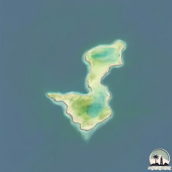
Welcome to Figure of Eight, a Temperate island in the Great Australian Bight, part of the majestic Indian Ocean. This guide offers a comprehensive overview of what makes Figure of Eight unique – from its geography and climate to its population, infrastructure, and beyond. Dive into the details:
Geography and size of Figure of Eight
Size: 2.484 km²
Coastline: 11.2 km
Ocean: Indian Ocean
Sea: Great Australian Bight
Continent: Oceania
Figure of Eight is a Small Island spanning 2.5 km² with a coastline of 11.2 km.
Archipel: –
Tectonic Plate: Australia – A major tectonic plate covering Australia, New Zealand, and parts of the Indian and Pacific Oceans, known for its relative stability and occasional seismic activity.
The geographic heart of the island is pinpointed at these coordinates:
Latitude: -34.02708236 / Longitude: 121.60693325
Climate and weather of Figure of Eight
Climate Zone: Temperate
Climate Details: Warm-Summer Mediterranean Climate
Temperature: Warm Summer
Climate Characteristics: Characterized by warm, dry summers and mild, wet winters, typical of coastal areas with abundant sunshine Rain is more common in the winter months, maintaining a moderate climate.
Topography and nature of Figure of Eight
Timezone: UTC+08:00
Timezone places: Australia/Perth
Max. Elevation: 34 m
Mean Elevation: 19 m
Vegetation: Evergreen Needleleaf Forest
Tree Coverage: 95%
The mean elevation is 19 m. The highest elevation on the island reaches approximately 34 meters above sea level. The island is characterized by Plains: Flat, low-lying lands characterized by a maximum elevation of up to 200 meters. On islands, plains are typically coastal lowlands or central flat areas.
Dominating Vegetation: Evergreen Needleleaf Forest
Dominated by evergreen coniferous trees such as pines and firs, which retain their needle-like leaves throughout the year. These forests are often found in cooler climates. Figure of Eight has a tree cover of 95 %.
Vegetation: 5 vegetation zones – Highly Diverse Island
With five different vegetation zones, these islands offer a rich tapestry of ecosystems. The variety could include dense forests, open meadows, wetlands, coastal zones, and more. This level of diversity supports an intricate web of life, with each zone playing a vital role in the overall ecological health and balance of the island.
Infrastructure and Travelling to Figure of Eight
Does the island have a public airport? no.
There is no public and scheduled airport on Figure of Eight. The nearest airport is Esperance Airport, located 43 km away.
Does the island have a major port? no.
There are no major ports on Figure of Eight. The closest major port is ESPERANCE, approximately 36 km away.
The mean population of Figure of Eight is 0 per km². Figure of Eight is Uninhabited. The island belongs to Australia.
Continuing your journey, Garden is the next notable island, situated merely km away.
32 Saltmeadow Road | Figure Eight Island
Sold March 2020 for $3175000 Presented by Jessica Edwards & The Carolinas Finest Team A coastal luxury estate located on ...32 Saltmeadow Road | Figure Eight Island
Sold March 2020 for $3175000 Presented by Jessica Edwards & The ...
Sold March 2020 for $3175000 Presented by Jessica Edwards & The Carolinas Finest Team A coastal luxury estate located on ...
Figure Eight Island
Check out all that Figure Eight has to offer! For booking and sales ...
Figure Eight Island | Most Expensive Homes in Wilmington, NC #wilmingtonnc #luxuryhomes
Welcome to Figure Eight Island! These homes are quite the destination, ...
Welcome to Figure Eight Island! These homes are quite the destination, and I love admiring them every time we take a boat ride ...
Exclusive Haven for Celebrities: Exploring Figure Eight Island in North Carolina
Discover the luxurious and prestigious Figure Eight Island in North ...
Discover the luxurious and prestigious Figure Eight Island in North Carolina, known as the Hamptons of the South. Learn about its ...
2020 Jet Ski Tour of Wrightsville Beach & Figure 8 Island
260 Beach Rd N, Figure Eight Island, NC
Timeless Coastal Elegance on Exclusive Figure Eight Island Experience ...
Timeless Coastal Elegance on Exclusive Figure Eight Island Experience the pinnacle of oceanfront living at 260 Beach Road ...
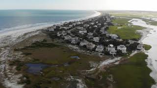
Early morning flyover of Figure Eight Island - Wilmington NC (DJI Mavic Pro)
Early morning flyover of Figure Eight Island located in Wilmington, ...
Early morning flyover of Figure Eight Island located in Wilmington, NC. Filmed with the DJI Mavic Pro. 4k / 30 fps. Date: 6/22/2019.
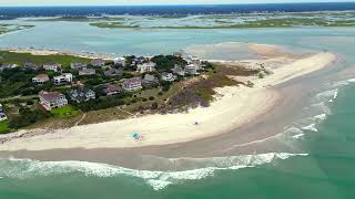
Wilmington, NC. Figure 8 Island from Drone.
Wrightsville beach Carolina Beach Topsail Beach Intercostal.
Wrightsville beach Carolina Beach Topsail Beach Intercostal.
520 Beach Road North | Figure Eight Island
For more information, click here: ...
For more information, click here: ...
Luxury home listing on PRIVATE Figure 8 Island | Coastal North Carolina
Luxury home listing on PRIVATE Figure 8 Island | Coastal North ...
Luxury home listing on PRIVATE Figure 8 Island | Coastal North Carolina Please join me in touring this luxury home listing on the ...
Figure Eight Island 2025
A couple visited family in Wilmington, NC.
A couple visited family in Wilmington, NC.
Figure Eight Island, NC | 507 Beach Rd N | For Sale
507 Beach Rd N on Figure Eight Island exceeds every expectation of ...
507 Beach Rd N on Figure Eight Island exceeds every expectation of luxury living. Located just north of Wrightsville Beach, this ...
Figure Eight Island NC Teaser Video v2
northcarolina Figure Eight Island NC #beach #summervibes #4k #aerial video.
northcarolina Figure Eight Island NC #beach #summervibes #4k #aerial video.
Will and Christy Spencer’s Figure Eight Island home.
Will and Christy Spencer's Figure Eight Island home. By: kenblevins1 ...
Will and Christy Spencer's Figure Eight Island home. By: kenblevins1 Published on: April 12, 2017 Source: ...
Figure Eight Island NC 2025
Figure Eight Island North Carolina #beachvibes #summer #4k ...
Figure Eight Island North Carolina #beachvibes #summer #4k #aerialvideos #dronevideo #djimini3pro.
North End Figure 8 Island
Figure 8 Island: Inside Wilmington North Carolina's Most Exclusive and Expensive Beach
Follow us on our journey of indulgence and discovery, where privacy ...
Follow us on our journey of indulgence and discovery, where privacy meets splendor only at Figure 8 Island! In this video, we take ...
Figure Eight Island Home Sells for $13.9M 💰
A modern oceanfront home on Figure Eight Island has sold for what's ...
A modern oceanfront home on Figure Eight Island has sold for what's believed to be a record-breaking $13.9 million. Download ...
Figure Eight Island Tour by Boat #privateisland #northcarolina 🌊🚤
You can only visit Figure Eight Island if you're invited so we took a ...
You can only visit Figure Eight Island if you're invited so we took a boat tour.
Figure Eight Island Swing Bridge. Motor Yacht cruises the ICW North. 2/8/22
Somewhere on the Water can be found travelling North on the ICW from ...
Somewhere on the Water can be found travelling North on the ICW from Carolina Beach, NC. February 8, 2022 Valkyrie is the first ...
Figure Eight Island Top # 5 Facts
Figure Eight Island Top # 5 Facts.
Figure Eight Island Top # 5 Facts.
FIgure EIght Island Tour.
Some great pictures and places to see on the island and in nearby ...
Some great pictures and places to see on the island and in nearby Wilmington, NC. Brought to you by TakeTheVideoTour.com ...
Figure 8 Island Yacht Club
An over-the-top view of our beautiful Yacht Club.
An over-the-top view of our beautiful Yacht Club.
Figure Eight Island - Wrightsville Beach - Wilmington NC Jul 2023
Midday flight with Mini3 Pro chased by angry rain clouds.. #dji ...
Midday flight with Mini3 Pro chased by angry rain clouds.. #dji #mini3pro #wilmingtonnc #wrightsvillebeach #drone #aerialfootage ...
Figure Eight Island: 188 Beach Road S (w/ Aerials)
Looking for a Virtual Tour of your residential or commercial property? ...
Looking for a Virtual Tour of your residential or commercial property? Contact Fly4Pix today for more information and pricing, ...
Australia is classified as Developed region: nonG7: Developed economies outside of the Group of Seven, characterized by high income and advanced economic structures. The level of income is High income: OECD.
News – Latest Updates and Headlines from Figure of Eight
Stay informed with the most recent news and important headlines from Figure of Eight. Here’s a roundup of the latest developments.
Loading...
Please note: The data used here has been primarily extracted from satellite readings. Deviations from exact values may occur, particularly regarding the height of elevations and population density. Land area and coastline measurements refer to average values at mean high tide.