Welcome to Fire, a Continental island in the The Coastal Waters of Southeast Alaska and British Columbia, part of the majestic Atlantic Ocean. This guide offers a comprehensive overview of what makes Fire unique – from its geography and climate to its population, infrastructure, and beyond. Dive into the details:
Geography and size of Fire
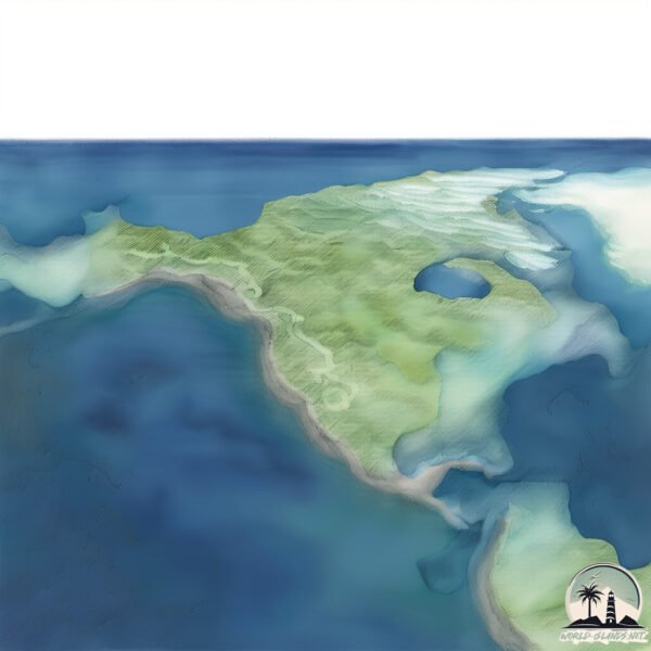
Size: 16.9 km²
Coastline: 93.6 km
Ocean: Atlantic Ocean
Sea: The Coastal Waters of Southeast Alaska and British Columbia
Continent: North America
Fire is a Medium Island spanning 17 km² with a coastline of 94 km.
Archipel: –
Tectonic Plate: North America – Covers North America and parts of the Atlantic and Arctic Oceans, characterized by diverse geological features and varying levels of seismic activity.
The geographic heart of the island is pinpointed at these coordinates:
Latitude: 52.03132607 / Longitude: -115.82592987
Climate and weather of Fire
Climate Zone: Continental
Climate Details: Warm, Dry-Summer Continental Climate
Temperature: Warm Summer
Climate Characteristics: Warm summers and cold winters with less summer rainfall. Typical in some inland northern areas.
Topography and nature of Fire
Timezone: UTC-05:00
Timezone places: America/New_York
Max. Elevation: 82 m
Mean Elevation: 46 m
Vegetation: Wetland
Tree Coverage: 72%
The mean elevation is 46 m. The highest elevation on the island reaches approximately 82 meters above sea level. The island is characterized by Plains: Flat, low-lying lands characterized by a maximum elevation of up to 200 meters. On islands, plains are typically coastal lowlands or central flat areas.
Dominating Vegetation: Wetland
These areas are saturated with water, either permanently or seasonally, and support aquatic plants. Wetlands are important for biodiversity and water filtration. Fire has a tree cover of 72 %.
Vegetation: 10 vegetation zones – Very Highly Diverse Island
Islands in this range are ecological powerhouses, showcasing a wide array of vegetation zones. Each zone, from lush rainforests to arid scrublands, coastal mangroves to mountainous regions, contributes to a complex and interdependent ecosystem. These islands are often hotspots of biodiversity, supporting numerous species and intricate ecological processes.
Infrastructure and Travelling to Fire
Does the island have a public airport? no.
There is no public and scheduled airport on Fire. The nearest airport is Long Island Mac Arthur Airport, located 15 km away.
Does the island have a major port? no.
There are no major ports on Fire. The closest major port is PATCHOGUE, approximately 7 km away.
The mean population of Fire is 7 per km². Fire is Gently Populated. The island belongs to United States of America.
Continuing your journey, Long Beach is the next notable island, situated merely km away.
FIRE ISLAND | Official Trailer | Searchlight Pictures
Now Streaming on Hulu Set in the iconic Pines, Andrew Ahn's FIRE ISLAND is an unapologetic, modern day rom-com ...FIRE ISLAND | Official Trailer | Searchlight Pictures
Now Streaming on Hulu Set in the iconic Pines, Andrew Ahn's FIRE ...
Now Streaming on Hulu Set in the iconic Pines, Andrew Ahn's FIRE ISLAND is an unapologetic, modern day rom-com ...
The Gayest 🏳️🌈 Island in the World
Fire Island
Provided to YouTube by Universal Music Group Fire Island · Fountains ...
Provided to YouTube by Universal Music Group Fire Island · Fountains Of Wayne Welcome Interstate Managers ℗ 2003 EMI ...
Why Tourists Keep GOING MISSING on FIRE ISLAND NYC…
What the HELL is Going on with FIRE ISLAND NEW YORK?!?! Join our ...
What the HELL is Going on with FIRE ISLAND NEW YORK?!?! Join our Exclusive Membership for Early Access ...
FIRE ISLAND | My first time | The gayest Island in the world
Spending sometime in New York, there is a must to go to Fire Island ...
Spending sometime in New York, there is a must to go to Fire Island Pines, which is the gayest island I ever visited with a very ...
FIRE ISLAND | "Heads Up" Clip | Searchlight Pictures
Now Streaming on Hulu Set in the iconic Pines, Andrew Ahn's FIRE ...
Now Streaming on Hulu Set in the iconic Pines, Andrew Ahn's FIRE ISLAND is an unapologetic, modern day rom-com ...
Fire Island Trailer #1 (2022) | Rotten Tomatoes TV
Check out the new Fire Island Trailer starring Joel Kim Booster! Let ...
Check out the new Fire Island Trailer starring Joel Kim Booster! Let us know what you think in the comments below. ▻ Learn more ...
Sometimes (From "Fire Island")
Provided to YouTube by Universal Music Group Sometimes (From "Fire ...
Provided to YouTube by Universal Music Group Sometimes (From "Fire Island") · MUNA Sometimes ℗ 2022 20th Century Studios ...
[ENG] [I-LAND/3회] 두 번째 테스트_팀워크 ♬불타오르네(FIRE)_I-LANDER 200710 EP.3
'전 세계가 지켜보는 생존 게임이 시작된다' 제한된 시간 그리고 스스로의 선택 가장 진화된 아이돌이 탄생하는 곳 ...
'전 세계가 지켜보는 생존 게임이 시작된다' 제한된 시간 그리고 스스로의 선택 가장 진화된 아이돌이 탄생하는 곳 <I-LAND> 매주 ...
[ENG] [I-LAND/4회] 두 번째 테스트_팀워크 ♬ 불타오르네(FIRE)_GROUNDER 200717 EP.4
'전 세계가 지켜보는 생존 게임이 시작된다' 제한된 시간 그리고 스스로의 선택 가장 진화된 아이돌이 탄생하는 곳 ...
'전 세계가 지켜보는 생존 게임이 시작된다' 제한된 시간 그리고 스스로의 선택 가장 진화된 아이돌이 탄생하는 곳 <I-LAND> 매주 ...
Fire Island
Provided to YouTube by Scorpio Music Fire Island · Village People San ...
Provided to YouTube by Scorpio Music Fire Island · Village People San Francisco Macho Man (Original Album 1978) ℗ Can't Stop ...
RUSSIA'S ALCATRAZ - The toughest prison on Fire Island | Full Documentary
Behind bars in Russia is no fun - in our Documentary about Russia's ...
Behind bars in Russia is no fun - in our Documentary about Russia's toughest prison we show why! Terrorists, gunmen and mafia ...
Fire Island Trailer #1 (2022) | Movieclips Trailers
Check out Fire Island Official Trailer starring Joel Kim Booster! Let ...
Check out Fire Island Official Trailer starring Joel Kim Booster! Let us know what you think in the comments below.
People ARRESTED on Fire Island
fireisland #nychistory #gayhistory Watch all episodes of FINDING FIRE ...
fireisland #nychistory #gayhistory Watch all episodes of FINDING FIRE ISLAND! ➡️ Ep 1: “Gay Summer Camp” ...
Fire Haven - Full Song 5.1 (My Singing Monsters)
Fire Haven full song with Epic Wubbox! ⚡ All island songs: ...
Fire Haven full song with Epic Wubbox! ⚡ All island songs: ...
FIRE ISLAND | "I’m a Doctor" Clip | Searchlight Pictures
Now Streaming on Hulu Set in the iconic Pines, Andrew Ahn's FIRE ...
Now Streaming on Hulu Set in the iconic Pines, Andrew Ahn's FIRE ISLAND is an unapologetic, modern day rom-com ...
Cherry Grove 🍒 Fire Island NY 🔥🏖 Friday night walking tour to the Atlantic Ocean New York USA 2021
Cherry Grove Fire Island NY Friday night walking tour to the Atlantic ...
Cherry Grove Fire Island NY Friday night walking tour to the Atlantic Ocean New York USA 2021 Cherry Grove (often ...
Russias Alcatraz: Inside the Most Feared Maximum Security Prison! | Investigate Asia
The Fire Island - Russias Alcatraz | Investigate Asia Watch Behind ...
The Fire Island - Russias Alcatraz | Investigate Asia Watch Behind Bars Asia here: ...
Fire Island | Official Trailer | Hulu
Who's ready for the hottest summer ever? Stream #FireIsland on June 3. ...
Who's ready for the hottest summer ever? Stream #FireIsland on June 3. Set in the iconic Fire Island Pines, FIRE ISLAND is an ...
Fire Island - Fire Island
Junior Boys Own 1992 - Original Mix 'Drop the You and Me & get with ...
Junior Boys Own 1992 - Original Mix 'Drop the You and Me & get with Unity!' Want More? Old Skool ...
I visited the gayest island on Earth - Fire Island
I visited the gayest island on Earth - Fire Island IG: ...
Ocean Beach Fire Island NY 🔥🏖 walking tour Great South Bay Walk New York USA 🇺🇸 summer 2021 4K
Ocean Beach Fire Island NY walking tour Great South Bay Walk New York ...
Ocean Beach Fire Island NY walking tour Great South Bay Walk New York USA summer 2021 4K The largest village on ...
Fire Island featuring Love Nelson ‘There But For The Grace of God’ (Roach Motel Mix)
Crazy Facts About Fire Island! #shorts
United States of America is classified as Developed region: G7: Group of Seven – Major advanced economies, including Canada, France, Germany, Italy, Japan, the United Kingdom, and the United States. The level of income is High income: OECD.
News – Latest Updates and Headlines from Fire
Stay informed with the most recent news and important headlines from Fire. Here’s a roundup of the latest developments.
Loading...
Please note: The data used here has been primarily extracted from satellite readings. Deviations from exact values may occur, particularly regarding the height of elevations and population density. Land area and coastline measurements refer to average values at mean high tide.


![[ENG] [I-LAND/3회] 두 번째 테스트_팀워크 ♬불타오르네(FIRE)_I-LANDER 200710 EP.3](https://i.ytimg.com/vi/pu5cATr4eXg/mqdefault.jpg)
![[ENG] [I-LAND/4회] 두 번째 테스트_팀워크 ♬ 불타오르네(FIRE)_GROUNDER 200717 EP.4](https://i.ytimg.com/vi/m2z1p3lJtog/mqdefault.jpg)