Welcome to Flekkeroya, a Temperate island in the Skagerrak, part of the majestic Atlantic Ocean. This guide offers a comprehensive overview of what makes Flekkeroya unique – from its geography and climate to its population, infrastructure, and beyond. Dive into the details:
Geography and size of Flekkeroya
Size: 7.294 km²
Coastline: 29.1 km
Ocean: Atlantic Ocean
Sea: Skagerrak
Continent: Europe
Flekkeroya is a Small Island spanning 7.3 km² with a coastline of 29.1 km.
Archipel: –
Tectonic Plate: Eurasia – One of the world’s largest tectonic plates, the Eurasian Plate covers a significant portion of Europe and Asia. It’s characterized by diverse geological features, including the Ural Mountains, the European Plain, and the Himalayas formed from its collision with the Indian Plate.
The geographic heart of the island is pinpointed at these coordinates:
Latitude: 58.07513385 / Longitude: 7.99488891
Climate and weather of Flekkeroya
Climate Zone: Temperate
Climate Details: Temperate Oceanic Climate
Temperature: Warm Summer
Climate Characteristics: Known for its moderate year-round temperatures with ample rainfall and no dry season. Warm summers are characteristic.
Topography and nature of Flekkeroya
Timezone: UTC+01:00
Timezone places: Europe/Paris
Max. Elevation: 29 m
Mean Elevation: 10 m
Vegetation: Evergreen Needleleaf Forest
Tree Coverage: 86%
The mean elevation is 10 m. The highest elevation on the island reaches approximately 29 meters above sea level. The island is characterized by Plains: Flat, low-lying lands characterized by a maximum elevation of up to 200 meters. On islands, plains are typically coastal lowlands or central flat areas.
Dominating Vegetation: Evergreen Needleleaf Forest
Dominated by evergreen coniferous trees such as pines and firs, which retain their needle-like leaves throughout the year. These forests are often found in cooler climates. Flekkeroya has a tree cover of 86 %.
Vegetation: 7 vegetation zones – Very Highly Diverse Island
Islands in this range are ecological powerhouses, showcasing a wide array of vegetation zones. Each zone, from lush rainforests to arid scrublands, coastal mangroves to mountainous regions, contributes to a complex and interdependent ecosystem. These islands are often hotspots of biodiversity, supporting numerous species and intricate ecological processes.
Infrastructure and Travelling to Flekkeroya
Does the island have a public airport? no.
There is no public and scheduled airport on Flekkeroya. The nearest airport is Kristiansand Airport, Kjevik, located 15 km away.
Does the island have a major port? no.
There are no major ports on Flekkeroya. The closest major port is KRISTIANSAND, approximately 6 km away.
The mean population of Flekkeroya is 325 per km². Flekkeroya is Moderately Inhabited. The island belongs to Norway.
Continuing your journey, Tromoy is the next notable island, situated merely km away.
Flekkerøy - Vraget - Geiderøya - Mavic drone
Mavic Pro drone i litt motvind fra Nord.Flekkerøy - Vraget - Geiderøya - Mavic drone
Mavic Pro drone i litt motvind fra Nord.
Mavic Pro drone i litt motvind fra Nord.
Flekkerøy - Mæbøfjorden - Mavic drone
En liten tur fra Bøderiet til Tørjesundet og deretter hjem til Gråheia.
En liten tur fra Bøderiet til Tørjesundet og deretter hjem til Gråheia.
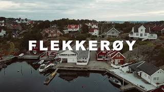
FLEKKERØY
Just a quick review of our week spent in a cabin on an island in ...
Just a quick review of our week spent in a cabin on an island in southern Norway and kayaking around the islands. Most of the trip ...
#Flekkerøya #Kristiansand #Norge #Norway by Drone 4K
Beautiful sunset - Norwegian islets - Flekkerøy - Mavic drone
A fast "ride" down "Målsfjorden", Flekkerøy - and thereafter towards ...
A fast "ride" down "Målsfjorden", Flekkerøy - and thereafter towards Oksøy lighthouse. Using Mavic drone in sportmode.
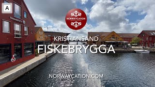
Fiskebrygga (The Fish Wharf) restaurant area in Kristiansand | Norwaycation.com - Vacation in Norway
Fiskebrygga (The Fish Wharf) is an maritime area with restaurants, a ...
Fiskebrygga (The Fish Wharf) is an maritime area with restaurants, a fishmarket and ice cream parlours. It is located in ...
Kristiansand: Norway's Coastal Jewel
Explore the hidden gem of Scandinavia—Kristiansand, Norway! 🏞️ From ...
Explore the hidden gem of Scandinavia—Kristiansand, Norway! 🏞️ From its stunning coastlines and majestic fjords to the charm ...
Fortress Odderoya Island - Kristiansand (Fortress Norway)
New video every Friday !!! – Nové video každý pátek !!! next fortress ...
Kristiansand, Norway - 4K Drone Footage #drone #dji #kristiansand #norway
Shot with DJI Mini 3.
Shot with DJI Mini 3.
Kristiansand, Flekkerøya✈️✈️
Norway’s Most Peaceful and Breath-taking Islands – A Drone Tour in 4K Kristiansand | The Travel Man
Discover the untouched beauty of Odderøya Islands and the scenic ...
Discover the untouched beauty of Odderøya Islands and the scenic coastline of Kristiansand, Norway all captured in breathtaking ...
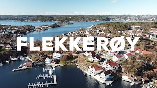
Flekkerøy - Norway
Flekkerøy or Flekkerøya is an island and residential district in ...
Flekkerøy or Flekkerøya is an island and residential district in Kristiansand municipality in Vest-Agder county, Norway. Area: 6.2 ...
Island hopping in Kristiansand with MS Bragdøya
Join the sightseeing boat MS Bragdøya on an island hopping excursion ...
Join the sightseeing boat MS Bragdøya on an island hopping excursion to the Kristiansand archipelago in Southern Norway.
YWAM Kristiansand - "We live on an island!"
Next base is the southernmost base in Norway - YWAM Kristiansand. ...
Next base is the southernmost base in Norway - YWAM Kristiansand. Idyllically situated on an island, the base is surrounded by ...
Flekkerøy - Fra Soloppgang til Sommer
Some stunning shots of this beautiful Norwegian island, Flekkerøy. ...
Some stunning shots of this beautiful Norwegian island, Flekkerøy. Starting in the winter and ending in the summer.
Wednesday, 30th July 2025, Kristiansand, Norway, Fiskebrygga
Wednesday, 30th July 2025, Solo walk to Odderoya Island before a ...
Wednesday, 30th July 2025, Solo walk to Odderoya Island before a return to the harbour front as the weather improved. Day 3 of ...
Top 10 Best Things to Do in Kristiansand, Norway [Kristiansand Travel Guide 2024]
Welcome to our guide on the best things to do in Kristiansand! Whether ...
Welcome to our guide on the best things to do in Kristiansand! Whether you're a local looking for new activities or a visitor ...
Kristiansand, Botanical Garden, Archive Foundation, Arkivet, Ravnedalen
Kristiansand, Botanical Garden, Archive Foundation, Arkivet, ...
Kristiansand, Botanical Garden, Archive Foundation, Arkivet, Ravnedalen Let's start the day off by visiting Agder Natural History ...
Brattåsen & Ansteins fyr - Flekkerøya
Exploring the southwestern part of the island Flekkerøya. Horrible ...
Exploring the southwestern part of the island Flekkerøya. Horrible wind and lots of turbulence. Great scenery, but quite scary!
Top 3 Must-Do Experiences in Kristiansand 🇳🇴
Top 3 Must-Do Experiences in Kristiansand Kristiansand, a coastal gem ...
Top 3 Must-Do Experiences in Kristiansand Kristiansand, a coastal gem in Southern Norway, offers a delightful mix of family ...
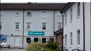
Walking tour in Roligheden Ferieleiligheter Kristiansand, Norway June 26-28, 2021
Nice place to stay close to the beach and friendly Reception.
Nice place to stay close to the beach and friendly Reception.
Kristiansand, Norway | 4K Drone Footage
Kristiansand from above in 4K, filmed during early summer 2025. This ...
Kristiansand from above in 4K, filmed during early summer 2025. This drone video captures the coastal charm of southern Norway ...
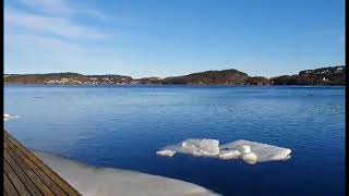
Spring day in Kristiansand 🇧🇻
Spring #Kristiansand The ice is disappearing at the Topdalsfjord and ...
Spring #Kristiansand The ice is disappearing at the Topdalsfjord and spring is coming Topdalsfjorden or Tofdalsfjorden is a fjord ...
Norway is classified as Developed region: nonG7: Developed economies outside of the Group of Seven, characterized by high income and advanced economic structures. The level of income is High income: OECD.
News – Latest Updates and Headlines from Flekkeroya
Stay informed with the most recent news and important headlines from Flekkeroya. Here’s a roundup of the latest developments.
Loading...
Please note: The data used here has been primarily extracted from satellite readings. Deviations from exact values may occur, particularly regarding the height of elevations and population density. Land area and coastline measurements refer to average values at mean high tide.


![Top 10 Best Things to Do in Kristiansand, Norway [Kristiansand Travel Guide 2024]](https://i.ytimg.com/vi/y6WJbh6EnAM/mqdefault.jpg)