Flores
Welcome to Flores, a Tropical island in the Flores Sea, part of the majestic Pacific Ocean. This guide offers a comprehensive overview of what makes Flores unique – from its geography and climate to its population, infrastructure, and beyond. Dive into the details:
- Geography and Size: Explore the island’s size and location.
- Climate and Weather: Weather patterns and temperature.
- Topography and Nature: Uncover the natural wonders of the island.
- Infrastructure and Travelling: Insights on reaching, staying, and making the most of your visit.
- News and Headlines: Latest News.
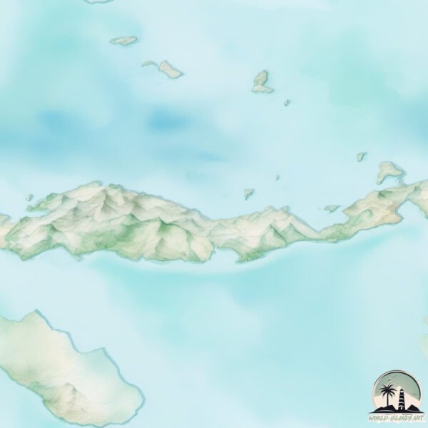
Geography and size of Flores
Size: 14128 km²
Coastline: 1374 km
Ocean: Pacific Ocean
Sea: Flores Sea
Continent: Asia
Flores is a Giant Island spanning 14128 km² with a coastline of 1374 km.
Archipel: Malay Archipelago – The world’s largest archipelago, located between mainland Southeast Asia and Australia, known for its immense biodiversity and cultural diversity.
Tectonic Plate: Timor – A small tectonic plate in the Timor region, primarily under the Timor Sea. It’s involved in the collision between the Australian and Eurasian plates, contributing to the region’s seismic activity and the uplift of the island of Timor.
The geographic heart of the island is pinpointed at these coordinates:
Latitude: -8.60474216 / Longitude: 121.14210931
Climate and weather of Flores
Climate Zone: Tropical
Climate Details: Tropical Savanna, Wet
Temperature: Hot
Climate Characteristics: Defined by distinct wet and dry seasons with high temperatures year-round. Pronounced rainfall occurs during the wet season, while the dry season is marked by drought.
Topography and nature of Flores
Timezone: UTC+08:00
Timezone places: Australia/Perth
Max. Elevation: 2370 m Poco Mandasawu
Mean Elevation: 488 m
Vegetation: Evergreen Broadleaf Forest
Tree Coverage: 49%
The mean elevation is 488 m. Dominating the island’s landscape, the majestic “Poco Mandasawu” rises as the highest peak, soaring to impressive heights. The island is characterized by Mountains: High, steeply elevated landforms. Characterized by both a high maximum elevation (over 500 meters) and a high mean elevation, creating rugged, mountainous terrains on islands.
Dominating Vegetation: Evergreen Broadleaf Forest
Characterized by dense, lush canopies of broadleaf trees that retain their leaves year-round. These forests are typically found in tropical and subtropical regions and are known for their high biodiversity. Flores has a tree cover of 49 %.
Vegetation: 16 vegetation zones – Exceptionally Diverse Island
Islands with more than ten vegetation zones are among the most ecologically rich and varied in the world. These islands are akin to miniature continents, boasting an incredible array of ecosystems. The sheer range of habitats, from high peaks to deep valleys, rainforests to deserts, creates a mosaic of life that is unparalleled. They are crucial for conservation and ecological studies.
Infrastructure and Travelling to Flores
Does the island have a public airport? yes.
Flores has a public and scheduled airport. The following airports are located on this island: Frans Xavier Seda Airport, H. Hasan Aroeboesman (Ende) Airport, Frans Sales Lega Airport, Komodo Airport, Larantuka Gewayentana Airport.
Does the island have a major port? yes.
Flores is home to a major port. The following ports are situated on the island: MAUMERE, ENDE.
The mean population of Flores is 142 per km². Flores is Moderately Inhabited. The island belongs to Indonesia.
The name of the island resonates across different cultures and languages. Here is how it is known around the world: Arabic: جزيرة فلوريس; German: Flores; Spanish: Isla de Flores; French: Florès; Portuguese: Flores; Russian: Флорес; Chinese: 弗洛勒斯岛
Continuing your journey, Pulau Mules is the next notable island, situated merely km away.
The HAWAII of EUROPE (Flores Island)


Indonesia is classified as Emerging region: MIKT: Mexico, Indonesia, South Korea, and Turkey – Economies recognized for their development potential and emerging market status. The level of income is Lower middle income.
News – Latest Updates and Headlines from Flores
Stay informed with the most recent news and important headlines from Flores. Here’s a roundup of the latest developments.
Social Media Posts about Flores
Please note: The data used here has been primarily extracted from satellite readings. Deviations from exact values may occur, particularly regarding the height of elevations and population density. Land area and coastline measurements refer to average values at mean high tide.