Fraser
Welcome to Fraser, a Temperate island in the Coral Sea, part of the majestic Pacific Ocean. This guide offers a comprehensive overview of what makes Fraser unique – from its geography and climate to its population, infrastructure, and beyond. Dive into the details:
- Geography and Size: Explore the island’s size and location.
- Climate and Weather: Weather patterns and temperature.
- Topography and Nature: Uncover the natural wonders of the island.
- Infrastructure and Travelling: Insights on reaching, staying, and making the most of your visit.
- News and Headlines: Latest News.
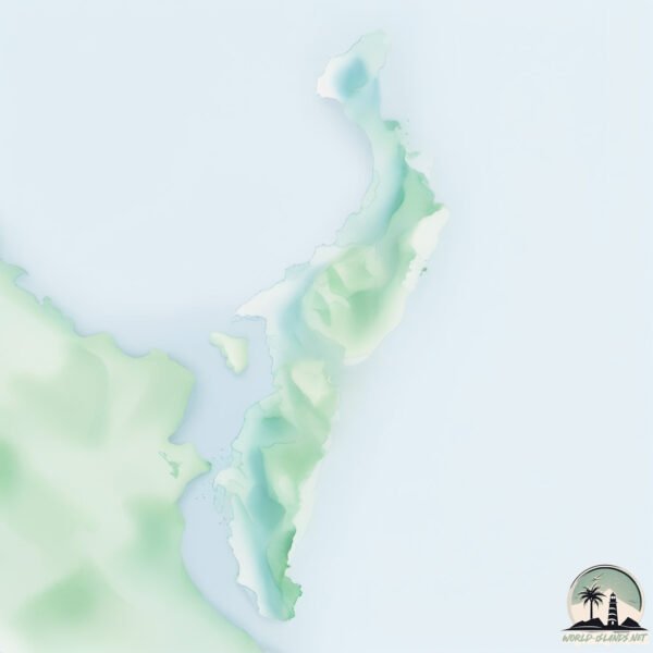
Geography and size of Fraser
Size: 1672 km²
Coastline: 412 km
Ocean: Pacific Ocean
Sea: Coral Sea
Continent: Oceania
Fraser is a Very Large Island spanning 1672 km² with a coastline of 412 km.
Archipel: –
Tectonic Plate: Australia – A major tectonic plate covering Australia, New Zealand, and parts of the Indian and Pacific Oceans, known for its relative stability and occasional seismic activity.
The geographic heart of the island is pinpointed at these coordinates:
Latitude: -25.2601939 / Longitude: 153.1429444
Climate and weather of Fraser
Climate Zone: Temperate
Climate Details: Humid Subtropical Climate
Temperature: Hot Summer
Climate Characteristics: With continuous rainfall and hot summers, this climate is common in some coastal regions, supporting diverse vegetation.
Topography and nature of Fraser
Timezone: UTC+10:00
Timezone places: Australia/Sydney
Max. Elevation: 215 m
Mean Elevation: 73 m
Vegetation: Evergreen Broadleaf Forest
Tree Coverage: 76%
The mean elevation is 73 m. The highest elevation on the island reaches approximately 215 meters above sea level. The island is characterized by Hills: Gently sloping landforms with rounded tops, having a maximum elevation between 200 and 500 meters. Hills contribute to a varied landscape on islands.
Dominating Vegetation: Evergreen Broadleaf Forest
Characterized by dense, lush canopies of broadleaf trees that retain their leaves year-round. These forests are typically found in tropical and subtropical regions and are known for their high biodiversity. Fraser has a tree cover of 76 %.
Vegetation: 11 vegetation zones – Exceptionally Diverse Island
Islands with more than ten vegetation zones are among the most ecologically rich and varied in the world. These islands are akin to miniature continents, boasting an incredible array of ecosystems. The sheer range of habitats, from high peaks to deep valleys, rainforests to deserts, creates a mosaic of life that is unparalleled. They are crucial for conservation and ecological studies.
Infrastructure and Travelling to Fraser
Does the island have a public airport? no.
There is no public and scheduled airport on Fraser. The nearest airport is Hervey Bay Airport, located 16 km away.
Does the island have a major port? no.
There are no major ports on Fraser. The closest major port is BUNDABERG, approximately 82 km away.
The mean population of Fraser is 0 per km². Fraser is Uninhabited. The island belongs to Australia.
The name of the island resonates across different cultures and languages. Here is how it is known around the world: Arabic: جزيرة فريرز; German: Fraser Island; Spanish: Isla Fraser; French: île Fraser; Portuguese: Ilha Fraser; Russian: Фрейзер; Chinese: 弗雷澤島
Continuing your journey, Turkey is the next notable island, situated merely km away.
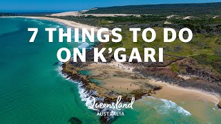
Must-do experiences on K'gari (Formerly Fraser Island)

Australia is classified as Developed region: nonG7: Developed economies outside of the Group of Seven, characterized by high income and advanced economic structures. The level of income is High income: OECD.
News – Latest Updates and Headlines from Fraser
Stay informed with the most recent news and important headlines from Fraser. Here’s a roundup of the latest developments.
Social Media Posts about Fraser
Please note: The data used here has been primarily extracted from satellite readings. Deviations from exact values may occur, particularly regarding the height of elevations and population density. Land area and coastline measurements refer to average values at mean high tide.