Welcome to Frazer’s Hog Cay, a Tropical island in the North Atlantic Ocean, part of the majestic Atlantic Ocean. This guide offers a comprehensive overview of what makes Frazer’s Hog Cay unique – from its geography and climate to its population, infrastructure, and beyond. Dive into the details:
Geography and size of Frazer’s Hog Cay
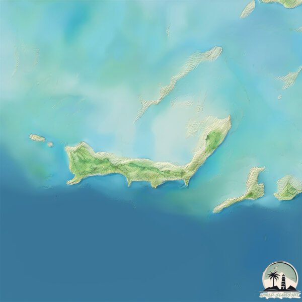
Size: 7.654 km²
Coastline: 24.7 km
Ocean: Atlantic Ocean
Sea: North Atlantic Ocean
Continent: North America
Frazer’s Hog Cay is a Small Island spanning 7.7 km² with a coastline of 24.7 km.
Archipel: Bahama Islands – An archipelago in the Atlantic Ocean, known for their stunning beaches, coral reefs, and vibrant culture.
Tectonic Plate: North America – Covers North America and parts of the Atlantic and Arctic Oceans, characterized by diverse geological features and varying levels of seismic activity.
The geographic heart of the island is pinpointed at these coordinates:
Latitude: 25.41638718 / Longitude: -77.86875358
Climate and weather of Frazer’s Hog Cay
Climate Zone: Tropical
Climate Details: Tropical Savanna, Wet
Temperature: Hot
Climate Characteristics: Defined by distinct wet and dry seasons with high temperatures year-round. Pronounced rainfall occurs during the wet season, while the dry season is marked by drought.
Topography and nature of Frazer’s Hog Cay
Timezone: UTC-05:00
Timezone places: America/New_York
Max. Elevation: 4 m
Mean Elevation: -2 m
Vegetation: Mixed Forest
Tree Coverage: 84%
The mean elevation is -2 m. The highest elevation on the island reaches approximately 4 meters above sea level. The island is characterized by Plains: Flat, low-lying lands characterized by a maximum elevation of up to 200 meters. On islands, plains are typically coastal lowlands or central flat areas.
Dominating Vegetation: Mixed Forest
A combination of both deciduous and evergreen trees, often found in transitional zones between forest types. These forests offer a diverse habitat for various wildlife species. Frazer’s Hog Cay has a tree cover of 84 %.
Vegetation: 6 vegetation zones – Very Highly Diverse Island
Islands in this range are ecological powerhouses, showcasing a wide array of vegetation zones. Each zone, from lush rainforests to arid scrublands, coastal mangroves to mountainous regions, contributes to a complex and interdependent ecosystem. These islands are often hotspots of biodiversity, supporting numerous species and intricate ecological processes.
Infrastructure and Travelling to Frazer’s Hog Cay
Does the island have a public airport? yes.
Frazer’s Hog Cay has a public and scheduled airport. The following airports are located on this island: Chub Cay Airport.
Does the island have a major port? no.
There are no major ports on Frazer’s Hog Cay. The closest major port is CLIFTON PIER, approximately 56 km away.
The mean population of Frazer’s Hog Cay is 15 per km². Frazer’s Hog Cay is Gently Populated. The island belongs to The Bahamas.
Continuing your journey, Bamboo Cay is the next notable island, situated merely km away.
E20: Frazer's Hog Cay, Bahamas Bahamas Express
An overnight sail to Chubb Cay from Bimini leads us to Frazer's Hog Cay. Beautiful. Serene. Quiet. I FINALLY get to go swimming ...E20: Frazer's Hog Cay, Bahamas Bahamas Express
An overnight sail to Chubb Cay from Bimini leads us to Frazer's Hog ...
An overnight sail to Chubb Cay from Bimini leads us to Frazer's Hog Cay. Beautiful. Serene. Quiet. I FINALLY get to go swimming ...
Ft. Lauderdale to Bimini and Frazer's Hog Cay!
We arrive in Ft. Lauderdale, and just before the end of the year we ...
We arrive in Ft. Lauderdale, and just before the end of the year we take off for Miami and then the Bahamas!
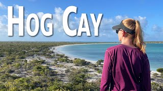
Hog Cay, The Raggeds, The Bahamas: Exploring the trails & beaches
Remote, uninhabited, quiet, serene, and hilly, Hog Cay in the Raggeds ...
Remote, uninhabited, quiet, serene, and hilly, Hog Cay in the Raggeds of the Bahamas is full of wonder -- blue waters, white sand ...
Sailing to Chub
Sailing to Chub Key from Frazer's Hog Cay, Berry Islands, Bahamas.
Sailing to Chub Key from Frazer's Hog Cay, Berry Islands, Bahamas.
BV8: Explorkeling Under the Abaco Sea at Hog Cay
Time to go explorkeling!” shouts Scuba Annie! Yes, Phillip loves ...
Time to go explorkeling!” shouts Scuba Annie! Yes, Phillip loves cruising with me. This was our first stop after we wrapped our ...
Episode 8: Sailing our Catamaran from Hog Cay to Georgetown, Exuma Islands, Bahamas.
In this episode, we sail to Pig Beach on Big Major Cay and feed and ...
In this episode, we sail to Pig Beach on Big Major Cay and feed and get chased by pigs. We find the best Laundromat in the area ...
Chub Cay Acreage, Berry Islands | Bahamas Real Estate
Quintessential island lifestyle is yours for the taking! Get a ...
Quintessential island lifestyle is yours for the taking! Get a panoramic sea view with ten acres of pristine coastal land including ...
Miami-Opa Locka Executive to Hog Cay, Exuma,Bahamas.TBM-930.Microsoft Flight Simulator 2020.
"Flying the TBM-930 from Miami to Exuma at yhe Bahamas on Microsoft ...
"Flying the TBM-930 from Miami to Exuma at yhe Bahamas on Microsoft Flight Simulator 2020". #yankyvictoronFS2020.
Sailing the Jumentos: Exploring a Hidden Gem
Fellow boaters - I'm thrilled to share my latest project with you: ...
Fellow boaters - I'm thrilled to share my latest project with you: MaintenanceROS! Crafted from my experiences aboard Starry ...
TreasureAir.com - 1 (305) 741-0489 Charter Flights to the Bahamas
Sampson Cay HOA Signed
The Government signs a heads of agreement for a resort development on ...
The Government signs a heads of agreement for a resort development on Sampson Cay in the Exumas.
From the Berry Islands Bahamas to Miami | Sailing Ventolines
Travel by boat means you have to pick your anchorage carefully. After ...
Travel by boat means you have to pick your anchorage carefully. After a few days at Bird Cay the swell become too great for us to ...
Best Sailing Route: FL to George Town, Bahamas (Video Cruising Guide)
A step-by-step sailing route from south Florida to George Town, ...
A step-by-step sailing route from south Florida to George Town, Bahamas, including some of the best places to stop along the way ...
The Great Bahama Bank, The Berry Islands and Nassau, #31.
We leave Bimini and cross the Great Bahama Bank, anchoring on the ...
We leave Bimini and cross the Great Bahama Bank, anchoring on the eastern side for the night. We then spend two nights in ...
Bahamas Cruising//Sailing, Spearfishing and Avoiding Gales | 12
Chris explores the healthy reef system around Hoffman Cay and then we ...
Chris explores the healthy reef system around Hoffman Cay and then we hunker down at Chub Cay Marina to wait out ...
More Development for the Bahamas: Big Sampson Cay Development get's the green light for Exuma...
Sandy Island Carriacou 4th of July and Sailing to Ronde Island S6Ep32
Lindy cooks up some delicious food on our Tartan 37 sailboat, Holiday, ...
Lindy cooks up some delicious food on our Tartan 37 sailboat, Holiday, as we hang out at Sandy Island for the 4th of July and the ...
The Berries...
From Frazer's Hog Cay to Great Harbour Cay and Coco Cay. Cheers.
From Frazer's Hog Cay to Great Harbour Cay and Coco Cay. Cheers.
E24: Bunch o' Pigs Bahamas Express
The Bahamas Express crew expands by one, and we explore Staniel Cay ...
The Bahamas Express crew expands by one, and we explore Staniel Cay Bahamas. Pig Beach, Thunderball Grotto (so named ...
E21 Conflicted Bahamas Express
Flo's is deserted, and no bread from Chester. Mysterious fishing boats ...
Flo's is deserted, and no bread from Chester. Mysterious fishing boats and a private cay. Bahamas Express explores near Frozen ...
SDA34 5F Farmers Cay First Friday in February Festival
If you get the opportunity to attend the Farmers Cay First Friday in ...
If you get the opportunity to attend the Farmers Cay First Friday in February Festival, go for it! The people are the friendliest you'll ...
Great Fishing Day in Bahamas Waters in my Solo Gulf Stream Crossing Miami to Bimini
Traveling to Tropical Places ,Fishing ,Free Diving ,Cooking my Meals ...
Traveling to Tropical Places ,Fishing ,Free Diving ,Cooking my Meals in my Small 21 feet Crooked Pilothouse Boat, Discovering ...
E23 Plane Crash Bahamas Express
Bahamas Express (Nov 2019) aboard "Good Life" (Lagoon 420 catamaran), ...
Bahamas Express (Nov 2019) aboard "Good Life" (Lagoon 420 catamaran), Brian, Captain Mark and I work our way down to the ...
The Bahamas is classified as Developing region: Regions characterized by lower income levels, with economies in the process of industrialization and modernization. The level of income is High income: nonOECD.
News – Latest Updates and Headlines from Frazer’s Hog Cay
Stay informed with the most recent news and important headlines from Frazer’s Hog Cay. Here’s a roundup of the latest developments.
Loading...
Please note: The data used here has been primarily extracted from satellite readings. Deviations from exact values may occur, particularly regarding the height of elevations and population density. Land area and coastline measurements refer to average values at mean high tide.