Welcome to Friendship, a Continental island in the North Atlantic Ocean, part of the majestic Atlantic Ocean. This guide offers a comprehensive overview of what makes Friendship unique – from its geography and climate to its population, infrastructure, and beyond. Dive into the details:
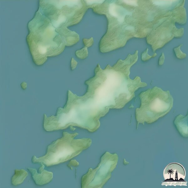
Geography and size of Friendship
Size: 2.776 km²
Coastline: 12.6 km
Ocean: Atlantic Ocean
Sea: North Atlantic Ocean
Continent: North America
Friendship is a Small Island spanning 2.8 km² with a coastline of 12.6 km.
Archipel: –
Tectonic Plate: North America – Covers North America and parts of the Atlantic and Arctic Oceans, characterized by diverse geological features and varying levels of seismic activity.
The geographic heart of the island is pinpointed at these coordinates:
Latitude: 43.95306095 / Longitude: -69.34663552
Climate and weather of Friendship
Climate Zone: Continental
Climate Details: Warm-Summer Humid Continental Climate
Temperature: Warm Summer
Climate Characteristics: Features warm summers and cold winters with consistent precipitation, common in higher latitudes.
Topography and nature of Friendship
Timezone: UTC-05:00
Timezone places: America/New_York
Max. Elevation: 24 m
Mean Elevation: 10 m
Vegetation: Evergreen Needleleaf Forest
Tree Coverage: 98%
The mean elevation is 10 m. The highest elevation on the island reaches approximately 24 meters above sea level. The island is characterized by Plains: Flat, low-lying lands characterized by a maximum elevation of up to 200 meters. On islands, plains are typically coastal lowlands or central flat areas.
Dominating Vegetation: Evergreen Needleleaf Forest
Dominated by evergreen coniferous trees such as pines and firs, which retain their needle-like leaves throughout the year. These forests are often found in cooler climates. Friendship has a tree cover of 98 %.
Vegetation: 3 vegetation zones – Moderately Diverse Island
These islands start to show a broader range of ecological niches. With three vegetation zones, they may offer a mix of ecosystems like coastal areas, inland woods, and perhaps a distinct wetland or dry area. This diversity supports a wider range of flora and fauna, making these islands more ecologically complex than those with minimal diversity.
Infrastructure and Travelling to Friendship
Does the island have a public airport? no.
There is no public and scheduled airport on Friendship. The nearest airport is Augusta State Airport, located 64 km away.
Does the island have a major port? yes.
Friendship is home to a major port. The following ports are situated on the island: .
The mean population of Friendship is 0 per km². Friendship is Uninhabited. The island belongs to United States of America.
Continuing your journey, Southport is the next notable island, situated merely km away.
RUINING OUR FRIENDSHIP OVER ROBLOX VOICE CHAT ft. SCOTT KRESS
I invited Scott over to try the new Roblox game based off of Love Island and this is what happened... Scott's channel: @scottkress_ ...RUINING OUR FRIENDSHIP OVER ROBLOX VOICE CHAT ft. SCOTT KRESS
I invited Scott over to try the new Roblox game based off of Love ...
I invited Scott over to try the new Roblox game based off of Love Island and this is what happened... Scott's channel: @scottkress_ ...
ROBLOX LOVE ISLAND NEEDS TO BE STOPPED
MY FRIENDS AND I TESTED OUR FRIENDSHIP ON ROBLOXS 'FRIENDSHIP ...
MY FRIENDS AND I TESTED OUR FRIENDSHIP ON ROBLOXS 'FRIENDSHIP ISLAND'...it was interesting Become A Channel ...
YOU THINK WE GETTING THE HUZZ 😱| Friendship Island Roblox
Drop a comment with your best plays in Roblox Rivals! Don't forget to ...
Drop a comment with your best plays in Roblox Rivals! Don't forget to like, subscribe, and hit the bell so you don't miss future ...
I find love in friendship island...
this is NOT a friendship island. bf: @SkilchSwift12 #roblox ...
this is NOT a friendship island. bf: @SkilchSwift12 #roblox #friendshipisland #loveisland ♡ business inquiries: ...
Friendship Island Forces Unwanted Relationships | AggressiveScot
Viewer request today and I haven't done one of these in awhile so this ...
Viewer request today and I haven't done one of these in awhile so this is for all the viewers who are tired of seeing the podcast ...
Playing Friendship Island w/Johnnie!
COME WATCH WHILE IM LIVE ON TWITCH! Twitch: ...
“ROBLOXIAN” FRIENDSHIPS BE LIKE…
ROBLOX FRIENDSHIP ISLAND - WE ACTUALLY HAD A REUNION REWIND THE CLIPS! I NEED THAT!
Subscribe to my 2nd Youtube Channel! ...
Friendship Island is SO Funny 😭 #roblox #robloxvoicechat
Finding real connections in Roblox Love Island
Waffle supremacy Im sorry the music is so loud but the people still ...
Waffle supremacy Im sorry the music is so loud but the people still wanted it so enjoy.
ROBLOX LOVE ISLAND
want to watch the next video LIVE? » FOLLOW ME ON TWITCH ...
Friendship Island w/Johnnie (Full Stream)
COME WATCH WHILE IM LIVE ON TWITCH! Twitch: ...
LOVE ISLAND IN ROBLOX! Friendship Island
this week i played friendship island with yza! we met some cool (and ...
this week i played friendship island with yza! we met some cool (and not so cool) people and i hope you enjoy this video as much ...
getting bullied on Roblox Love Island
Going to therapy is a sign of strength, not weakness. My sponsor ...
Going to therapy is a sign of strength, not weakness. My sponsor BetterHelp makes therapy simple, with 10% off your first month to ...
EVERYONE is AGAINST ME in Friendship Island!
Who Should We Vote Off First?? Come take a look at my merch! ...
ROBLOX FRIENDSHIP ISLAND ME AND CALI I SWEAR DID NOT MEET BEFORE THE SHOW WE JUST MET! 🤫🤭 NO LIES!
Subscribe to my 2nd Youtube Channel! ...
Love Island in Roblox is HILARIOUS (Friendship Island)
Like and subscribe to help me grow #robloxfunny #roblox #funny ...
Like and subscribe to help me grow #robloxfunny #roblox #funny #robloxvoicechat Roblox Username : NonLicensedNurse ...
WHY WE AREN'T FRIENDS..💔
WHY WE AREN'T FRIENDS.. ୨ hihihi its me belala and today me and ...
WHY WE AREN'T FRIENDS.. ୨ hihihi its me belala and today me and booshot are going to be playing roblox friendship ...
Roblox Love Island Is PEAK
Welcome to the Villa. In this video, we play Roblox Friendship Island ...
Welcome to the Villa. In this video, we play Roblox Friendship Island and it was one of the most unintentionally funny games I've ...
Playing LOVE ISLAND in ROBLOX | FRIENDSHIP ISLAND
I played LOVE ISLAND's remake in Roblox called FRIENDSHIP ISLAND, this ...
I played LOVE ISLAND's remake in Roblox called FRIENDSHIP ISLAND, this involves voice chat and is a lot of fun altogether.
🌈 ✨👥 FRIENDSHIP ISLAND! 🌈 ✨👥
want access to PAST VOD's, EXCLUSIVE CONTENT, & MEMBER-ONLY LIVES? ▻ ...
want access to PAST VOD's, EXCLUSIVE CONTENT, & MEMBER-ONLY LIVES? ▻ become a member of our PATREON!
roblox needs to ban us FOR LIFE 😭 ft Stinky Asher
I kidnapped my bestie Mr. Stinky Asher to make another roblox video ...
I kidnapped my bestie Mr. Stinky Asher to make another roblox video with me and lets just say it was EVENTFUL.... in todays video ...
MY BOYFRIEND BACKSTABBED ME in LOVE ISLAND! - Roblox (Friendship Island)
My boyfriend backstabbed me, can I get revenge?! I played Roblox Total ...
My boyfriend backstabbed me, can I get revenge?! I played Roblox Total Drama Island nefore but now we are playing Roblox ...
United States of America is classified as Developed region: G7: Group of Seven – Major advanced economies, including Canada, France, Germany, Italy, Japan, the United Kingdom, and the United States. The level of income is High income: OECD.
News – Latest Updates and Headlines from Friendship
Stay informed with the most recent news and important headlines from Friendship. Here’s a roundup of the latest developments.
Loading...
Please note: The data used here has been primarily extracted from satellite readings. Deviations from exact values may occur, particularly regarding the height of elevations and population density. Land area and coastline measurements refer to average values at mean high tide.