Fuerteventura
Welcome to Fuerteventura, a Dry island in the North Atlantic Ocean, part of the majestic Atlantic Ocean. This guide offers a comprehensive overview of what makes Fuerteventura unique – from its geography and climate to its population, infrastructure, and beyond. Dive into the details:
- Geography and Size: Explore the island’s size and location.
- Climate and Weather: Weather patterns and temperature.
- Topography and Nature: Uncover the natural wonders of the island.
- Infrastructure and Travelling: Insights on reaching, staying, and making the most of your visit.
- News and Headlines: Latest News.
Geography and size of Fuerteventura
Size: 1671 km²
Coastline: 304 km
Ocean: Atlantic Ocean
Sea: North Atlantic Ocean
Continent: Africa
Fuerteventura is a Very Large Island spanning 1671 km² with a coastline of 304 km.
Archipel: Canary Islands – A Spanish archipelago off the coast of northwestern Africa, known for their volcanic landscapes, unique ecosystems, and vibrant cultures.
Tectonic Plate: Africa – One of the world’s largest tectonic plates, covering the African continent and parts of the surrounding oceans, known for its stability with some active rift zones.
The geographic heart of the island is pinpointed at these coordinates:
Latitude: 28.40640262 / Longitude: -14.03598512
Climate and weather of Fuerteventura
Climate Zone: Dry
Climate Details: Hot Deserts Climate
Temperature: Hot
Climate Characteristics: Dominated by extremely hot temperatures, this climate is marked by minimal rainfall and barren landscapes. Nights often experience drastic temperature drops.
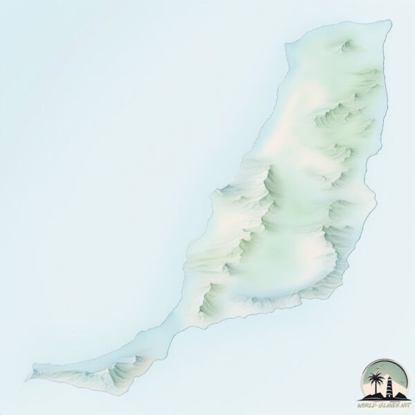
Topography and nature of Fuerteventura
Timezone: UTC±00:00
Timezone places: Europe/Lisbon
Max. Elevation: 623 m
Mean Elevation: 173 m
Vegetation: Rocky Terrain
Tree Coverage: 2%
The mean elevation is 173 m. The highest elevation on the island reaches approximately 623 meters above sea level. The island is characterized by Plateau: Elevated flatlands rising sharply above the surrounding area, with a maximum elevation over 500 meters but a mean elevation less than 300 meters, forming unique highland areas on islands.
Dominating Vegetation: Rocky Terrain
Landscapes dominated by gravel, rock, and stone, with little to no vegetation. These areas are often found in mountainous regions or deserts. Fuerteventura has a tree cover of 2 %.
Vegetation: 10 vegetation zones – Very Highly Diverse Island
Islands in this range are ecological powerhouses, showcasing a wide array of vegetation zones. Each zone, from lush rainforests to arid scrublands, coastal mangroves to mountainous regions, contributes to a complex and interdependent ecosystem. These islands are often hotspots of biodiversity, supporting numerous species and intricate ecological processes.
Infrastructure and Travelling to Fuerteventura
Does the island have a public airport? yes.
Fuerteventura has a public and scheduled airport. The following airports are located on this island: Fuerteventura Airport.
Does the island have a major port? yes.
Fuerteventura is home to a major port. The following ports are situated on the island: PUERTO DEL ROSARIO.
The mean population of Fuerteventura is 74 per km². Fuerteventura is Gently Populated. The island belongs to Spain.
The name of the island resonates across different cultures and languages. Here is how it is known around the world: Arabic: فويرتيفنتورا; German: Fuerteventura; Spanish: Fuerteventura; French: Fuerteventura; Portuguese: Fuerteventura; Russian: Фуэртевентура; Chinese: 富埃特文图拉岛
Continuing your journey, Lanzarote is the next notable island, situated merely km away.
Top 10 Places to Visit in Fuerteventura 2025 | Best Things to Do & See | Travel Guide 4K


Spain is classified as Developed region: nonG7: Developed economies outside of the Group of Seven, characterized by high income and advanced economic structures. The level of income is High income: OECD.
News – Latest Updates and Headlines from Fuerteventura
Stay informed with the most recent news and important headlines from Fuerteventura. Here’s a roundup of the latest developments.
Social Media Posts about Fuerteventura
Please note: The data used here has been primarily extracted from satellite readings. Deviations from exact values may occur, particularly regarding the height of elevations and population density. Land area and coastline measurements refer to average values at mean high tide.