Welcome to Galoa Island, a Tropical island in the South Pacific Ocean, part of the majestic Pacific Ocean. This guide offers a comprehensive overview of what makes Galoa Island unique – from its geography and climate to its population, infrastructure, and beyond. Dive into the details:
Geography and size of Galoa Island
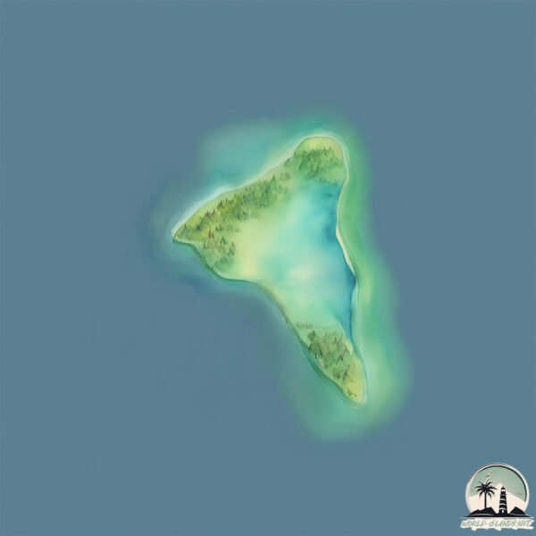
Size: 0.949 km²
Coastline: 5.2 km
Ocean: Pacific Ocean
Sea: South Pacific Ocean
Continent: Oceania
Galoa Island is a Tiny Island spanning 0.949 km² with a coastline of 5.2 km.
Archipel: Fiji – Fiji, an archipelago in the South Pacific Ocean, is composed of more than 300 islands and is famed for its stunning coral reefs, beautiful tropical beaches, and rich cultural heritage. It’s a popular tourist destination, offering a range of activities from snorkeling to exploring traditional Fijian villages. Fiji’s diverse population has created a unique blend of indigenous, Indian, Chinese, and European cultures.
Tectonic Plate: Australia – A major tectonic plate covering Australia, New Zealand, and parts of the Indian and Pacific Oceans, known for its relative stability and occasional seismic activity.
The geographic heart of the island is pinpointed at these coordinates:
Latitude: -16.61613823 / Longitude: 178.68700925
Climate and weather of Galoa Island
Climate Zone: Tropical
Climate Details: Tropical Rainforest Climate
Temperature: Hot
Climate Characteristics: This climate is typified by heavy rainfall throughout the year, high humidity, and consistently high temperatures, leading to lush rainforests and rich biodiversity. Seasonal temperature variations are minimal.
Topography and nature of Galoa Island
Timezone: UTC+12:00
Timezone places: Pacific/Auckland
Max. Elevation: 15 m
Mean Elevation: 13 m
Vegetation: Mangrove Forest
Tree Coverage: 97%
The mean elevation is 13 m. The highest elevation on the island reaches approximately 15 meters above sea level. The island is characterized by Plains: Flat, low-lying lands characterized by a maximum elevation of up to 200 meters. On islands, plains are typically coastal lowlands or central flat areas.
Dominating Vegetation: Mangrove Forest
Found in coastal areas and river deltas, these unique wetland ecosystems are adapted to saline conditions and are crucial for coastal protection and biodiversity. Galoa Island has a tree cover of 97 %.
Vegetation: 2 vegetation zones – Low Diversity Island
Islands with two distinct vegetation zones offer slightly more ecological variety. These zones could be due to differences in elevation, moisture, or other environmental factors. While still limited in biodiversity, these islands may offer a contrast between the two zones, such as a coastline with mangroves and an inland area with grassland.
Infrastructure and Travelling to Galoa Island
Does the island have a public airport? no.
There is no public and scheduled airport on Galoa Island. The nearest airport is Labasa Airport, located 74 km away.
Does the island have a major port? no.
There are no major ports on Galoa Island. The closest major port is SAVUSAVU BAY, approximately 73 km away.
The mean population of Galoa Island is 23 per km². Galoa Island is Gently Populated. The island belongs to Fiji.
Continuing your journey, Yadua Island is the next notable island, situated merely km away.
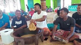
Galoa Island Rural Water Scheme
The Rural Water Scheme was established to ensure that Fijians in rural areas also have access to clean and safe drinking water.Galoa Island Rural Water Scheme
The Rural Water Scheme was established to ensure that Fijians in rural ...
The Rural Water Scheme was established to ensure that Fijians in rural areas also have access to clean and safe drinking water.
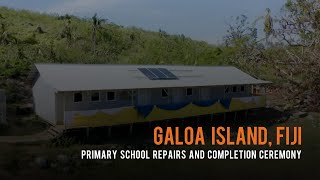
Galoa Island Primary School repairs and completion ceremony Fiji
Fijian dignitaries attended Galoa Island Primary School for the ...
Fijian dignitaries attended Galoa Island Primary School for the completion ceremony, the culmination of reconstruction efforts by ...
Galoa Island Primary school, Bua Province
View from Nabouwalu Police station.
View from Nabouwalu Police station.
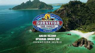
Survivor Game Changers - Galoa Island
Vanacore Music created the sound of Survivor Game Changers, inspired ...
Vanacore Music created the sound of Survivor Game Changers, inspired by the culture and people of the Mamanuca Islands.
Reconstruction of the primary school on Galoa Island, Fiji
Soldiers from 6th Engineer Support Regiment are working with engineers ...
Soldiers from 6th Engineer Support Regiment are working with engineers from the Republic of Fiji Military Force to help repair the ...
Fijian Minister for Education visits Galoa Island Primary School.
Fijian Minister for Education, Heritage and Arts Rosy Akbar today ...
Fijian Minister for Education, Heritage and Arts Rosy Akbar today visited Galoa Primary School in the Province of Bua which was ...
GALOA ISLAND WATER REHAB PROJECT - 06.11.18
WATCH video interviews of villagers of Galoa Island in Bua as they ...
WATCH video interviews of villagers of Galoa Island in Bua as they received normal water supply ending water woes and ...
Fidschi GALOA Island nach tropical Cyclon YASA - ein etwas anderes Weihnachten
FIJI - Galoa Island Church Visit - 1/2
Hi y'all ! - Part 1 of 2 Our Sunday morning visit to Galoa Island in ...
Hi y'all ! - Part 1 of 2 Our Sunday morning visit to Galoa Island in Northern Fiji where the sound of church bells and unbelievable ...
Galoa Island, Bua Fiji | 30/01/2021
13 families in Galoa Island move to evacuation centres Click here for ...
13 families in Galoa Island move to evacuation centres Click here for full story: ...
Fijian Minister for Education officiates at the handing-over of Galoa Island Primary School
Minister for Education, Hon. Rosy Akbar officiates at the handing-over ...
Minister for Education, Hon. Rosy Akbar officiates at the handing-over of Galoa Island Primary School rom the Department of ...
galoa kadavu fiji island 🏝
Fijian Prime Minister commissions the Island of Galoa Water Upgrading Project
VILLAGERS of Galoa in Bua will now have access to a safe, clean and ...
VILLAGERS of Galoa in Bua will now have access to a safe, clean and proper water supply after Prime Minister Hon. Voreqe ...
Post TC Yasa - HMAS Adelaide at Galoa Island in Bua, Vanua Levu.
GALOA ISLAND PRIMARY SCHOOL HANDOVER
What a moment when the #ADF handed over Galoa Island Primary School to ...
What a moment when the #ADF handed over Galoa Island Primary School to the Ministry of Education and the management of the ...
FIJI - Galoa Island Church Visit - 2/2
Hi y'all ! - Part 2 of 2 Our Sunday morning visit to Galoa Island in ...
Hi y'all ! - Part 2 of 2 Our Sunday morning visit to Galoa Island in Northern Fiji where the sound of church bells and unbelievable ...
After TC Yasa..Galoa Island,Bua, Fiji
Galoa island AOG New year Dance performed by Noke viro &Ben turaga. ...
Galoa island AOG New year Dance performed by Noke viro &Ben turaga. The aftermath of Tc YASA has left them with no shelter, ...
Au nui lo e Lomaqu(Sigidrigi @ Galoa Island 🏖🏝)
Stee(General),Jay Water,Ula(RIP )
Stee(General),Jay Water,Ula(RIP )
Visiting Galoa village in Fiji
Marina reservations volunteers visiting the Galoa village in Viti ...
Marina reservations volunteers visiting the Galoa village in Viti Levu, Fiji in July of 2022 Thank you for watching our videos Please ...
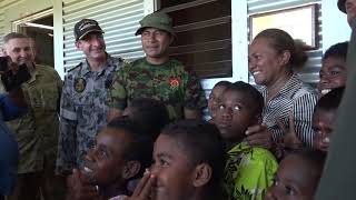
Operation Fiji Assist - Preparations for construction works underway in Galoa, Fiji.
The Australian Army embarked forces from HMAS Adelaide have started ...
The Australian Army embarked forces from HMAS Adelaide have started work on the island of Galoa, near Vanua Levu, in Fiji.
ADF and RFMF officially hands over Galoa Island Primary School to the Ministry of Education.
Epi 9 history on Galoa in Kadavu
ADF deploy to Operation Fiji Assist in response to Tropical Cyclone Yasa
The Australian Army embarked forces from HMAS Adelaide have started ...
The Australian Army embarked forces from HMAS Adelaide have started work on the northern island of Galoa, Fiji. Engineers from ...
Lomai Galoa - Kuki ft Jrexx Muziic Vude Remix 2024
fijiremix #vude #2024remix #jrexx.
fijiremix #vude #2024remix #jrexx.
Fiji is classified as Developing region: Regions characterized by lower income levels, with economies in the process of industrialization and modernization. The level of income is Lower middle income.
News – Latest Updates and Headlines from Galoa Island
Stay informed with the most recent news and important headlines from Galoa Island. Here’s a roundup of the latest developments.
Loading...
Please note: The data used here has been primarily extracted from satellite readings. Deviations from exact values may occur, particularly regarding the height of elevations and population density. Land area and coastline measurements refer to average values at mean high tide.