Ghagha
Welcome to Ghagha, a Dry island in the Persian Gulf, part of the majestic Indian Ocean. This guide offers a comprehensive overview of what makes Ghagha unique – from its geography and climate to its population, infrastructure, and beyond. Dive into the details:
- Geography and Size: Explore the island’s size and location.
- Climate and Weather: Weather patterns and temperature.
- Topography and Nature: Uncover the natural wonders of the island.
- Infrastructure and Travelling: Insights on reaching, staying, and making the most of your visit.
- News and Headlines: Latest News.
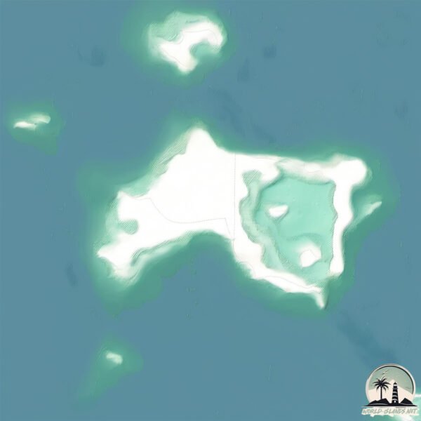
Geography and size of Ghagha
Size: 3.573 km²
Coastline: 13.3 km
Ocean: Indian Ocean
Sea: Persian Gulf
Continent: Asia
Ghagha is a Small Island spanning 3.6 km² with a coastline of 13.3 km.
Archipel: –
Tectonic Plate: India – A major tectonic plate that initially moved northward at a rapid pace before colliding with the Eurasian Plate. This collision is responsible for the uplift of the Himalayas and the Tibetan Plateau.
The geographic heart of the island is pinpointed at these coordinates:
Latitude: 24.41184519 / Longitude: 51.54716359
Climate and weather of Ghagha
Climate Zone: Dry
Climate Details: Hot Deserts Climate
Temperature: Hot
Climate Characteristics: Dominated by extremely hot temperatures, this climate is marked by minimal rainfall and barren landscapes. Nights often experience drastic temperature drops.
Topography and nature of Ghagha
Timezone: UTC+03:00
Timezone places: Asia/Riyadh
Max. Elevation: 5 m
Mean Elevation: 3 m
Vegetation: Sparse Vegetation
Tree Coverage: 38%
The mean elevation is 3 m. The highest elevation on the island reaches approximately 5 meters above sea level. The island is characterized by Plains: Flat, low-lying lands characterized by a maximum elevation of up to 200 meters. On islands, plains are typically coastal lowlands or central flat areas.
Dominating Vegetation: Sparse Vegetation
These regions have limited plant growth, typically due to extreme conditions like aridity or poor soils. Vegetation is scattered and consists of hardy plant species. Ghagha has a tree cover of 38 %.
Vegetation: 2 vegetation zones – Low Diversity Island
Islands with two distinct vegetation zones offer slightly more ecological variety. These zones could be due to differences in elevation, moisture, or other environmental factors. While still limited in biodiversity, these islands may offer a contrast between the two zones, such as a coastline with mangroves and an inland area with grassland.
Infrastructure and Travelling to Ghagha
Does the island have a public airport? no.
There is no public and scheduled airport on Ghagha. The nearest airport is Batha Airport, located 23 km away.
Does the island have a major port? no.
There are no major ports on Ghagha. The closest major port is UMM SAID, approximately 55 km away.
The mean population of Ghagha is 37 per km². Ghagha is Gently Populated. The island belongs to United Arab Emirates.
Continuing your journey, Al Yāsāt al ‘Ulyā is the next notable island, situated merely km away.
جزيرة غاغا في العاصمة أبوظبي Ghagha Island


United Arab Emirates is classified as Developing region: Regions characterized by lower income levels, with economies in the process of industrialization and modernization. The level of income is High income: nonOECD.
News – Latest Updates and Headlines from Ghagha
Stay informed with the most recent news and important headlines from Ghagha. Here’s a roundup of the latest developments.
Please note: The data used here has been primarily extracted from satellite readings. Deviations from exact values may occur, particularly regarding the height of elevations and population density. Land area and coastline measurements refer to average values at mean high tide.