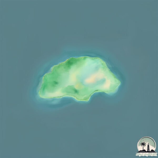
Welcome to Gili Lipan, a Tropical island in the Flores Sea, part of the majestic Pacific Ocean. This guide offers a comprehensive overview of what makes Gili Lipan unique – from its geography and climate to its population, infrastructure, and beyond. Dive into the details:
Geography and size of Gili Lipan
Size: 0.113 km²
Coastline: 1.3 km
Ocean: Pacific Ocean
Sea: Flores Sea
Continent: Asia
Gili Lipan is a Tiny Island spanning 0.113 km² with a coastline of 1.3 km.
Archipel: Malay Archipelago – The world’s largest archipelago, located between mainland Southeast Asia and Australia, known for its immense biodiversity and cultural diversity.
Tectonic Plate: Sunda – Extends across Southeast Asia, encompassing parts of the Sunda Shelf, known for its interaction with the Australian Plate, contributing to volcanic activity in Indonesia.
The geographic heart of the island is pinpointed at these coordinates:
Latitude: -8.65698169 / Longitude: 117.85967876
Climate and weather of Gili Lipan
Climate Zone: Tropical
Climate Details: Tropical Savanna, Wet
Temperature: Hot
Climate Characteristics: Defined by distinct wet and dry seasons with high temperatures year-round. Pronounced rainfall occurs during the wet season, while the dry season is marked by drought.
Topography and nature of Gili Lipan
Timezone: UTC+08:00
Timezone places: Australia/Perth
Max. Elevation: -1 m
Mean Elevation: -3 m
Vegetation: Evergreen Broadleaf Forest
Tree Coverage: 48%
The mean elevation is -3 m. Remarkably, this unique island barely emerges above the sea level, showcasing nature’s fascinating interplay with the ocean. The island is characterized by Plains: Flat, low-lying lands characterized by a maximum elevation of up to 200 meters. On islands, plains are typically coastal lowlands or central flat areas.
Dominating Vegetation: Evergreen Broadleaf Forest
Characterized by dense, lush canopies of broadleaf trees that retain their leaves year-round. These forests are typically found in tropical and subtropical regions and are known for their high biodiversity. Gili Lipan has a tree cover of 48 %.
Vegetation: 1 vegetation zones – Minimal Diversity Island
These islands exhibit the most basic level of ecological diversity, often characterized by a single dominant vegetation type. This could be due to extreme environmental conditions, limited land area, or significant human impact. They represent unique ecosystems where specific species have adapted to thrive in these singular environments.
Infrastructure and Travelling to Gili Lipan
Does the island have a public airport? no.
There is no public and scheduled airport on Gili Lipan. The nearest airport is Sumbawa Besar Airport, located 53 km away.
Does the island have a major port? no.
There are no major ports on Gili Lipan. The closest major port is TANJUNG BENETE, approximately 126 km away.
The mean population of Gili Lipan is 74 per km². Gili Lipan is Gently Populated. The island belongs to Indonesia.
Continuing your journey, Sumbawa is the next notable island, situated merely km away.
GILI ISLANDS, Lombok - Ultimate TRAVEL GUIDE to ALL Beaches, Snorkeling, TURTLES in 4K
Discover the Gili Islands: Indonesia's Most Beautiful Coral Paradise | Ultimate Island Hopping Guide ▶️ Join us as we explore ...GILI ISLANDS, Lombok - Ultimate TRAVEL GUIDE to ALL Beaches, Snorkeling, TURTLES in 4K
Discover the Gili Islands: Indonesia's Most Beautiful Coral Paradise | ...
Discover the Gili Islands: Indonesia's Most Beautiful Coral Paradise | Ultimate Island Hopping Guide ▶️ Join us as we explore ...
Gili Air vs. Gili Meno: Which Gili Island is the BEST? 🌴 #indonesia
In this video, we dive deep into the beautiful Gili Islands of ...
In this video, we dive deep into the beautiful Gili Islands of Indonesia, comparing Gili Air and Gili Meno to determine which island ...
We Vistited ALL THREE Gili Islands | The ONLY Travel Guide You NEED 🇮🇩
Today we're in Indonesia visiting all three Gili Islands, and this is ...
Today we're in Indonesia visiting all three Gili Islands, and this is the Gili travel guide we wish we had before coming here.
Gili Islands Travel Guide (why we're not going back)
We just returned from our trip traveling the Gili Islands, here's a ...
We just returned from our trip traveling the Gili Islands, here's a guide on everything you need to know and why we're not returning ...
Gili Island | Gili Island Bali | Island paradise #island #islandparadise
Gili Island Bali #giliislands #islands #baliisland #balitravel.
Gili Island Bali #giliislands #islands #baliisland #balitravel.
GILI ISLANDS COMPARISON : Gili Air vs Gili Meno vs Gili Trawangan
Welcome back to our channel 🙂 In this video, we're diving into the ...
Welcome back to our channel 🙂 In this video, we're diving into the crystal-clear waters and vibrant cultures of the three stunning ...
First time on Gili Trawangan island 🏝️ Best island near Bali? Snorkelling with turtles, beach cinema
It's our first time on Gili T island in Indonesia! I've always wanted ...
It's our first time on Gili T island in Indonesia! I've always wanted to visit the Gili Island and so during our trip to Bali we decided to ...
Exploring Lombok & The Gili Islands // Better than Bali?
We explore the famous Gili Islands (Gili Trawangan, Gili Meno and Gili ...
We explore the famous Gili Islands (Gili Trawangan, Gili Meno and Gili Air) with our own private boat. Snorkeling on the Gili ...
Things to do at Gili Trawangan, Lombok, Indonesia #indonesia #gilitrawangan #giliislands #travel
5 Things No One Tells You About The Gili Islands #shorts #giliislands
Gili T - Unique party island | Must Visit #indonesia
Gili Trawangan, Indonesia. It's a unique party island near Bali that ...
Gili Trawangan, Indonesia. It's a unique party island near Bali that you must visit.
gili lipan sumbawa , NTB
teluksaleh #gililipan #ayokesumbawa #visitsumbawa #jelajahsumbawa.
teluksaleh #gililipan #ayokesumbawa #visitsumbawa #jelajahsumbawa.
The Secret Gili Islands became my favorite spot in Lombok #lombok #indonesia #travel #islands
Best Things to Do on Gili Air | A Sea Turtle Paradise
Gili Air, one of the three Gili Islands off the coast of Lombok in ...
Gili Air, one of the three Gili Islands off the coast of Lombok in Indonesia. This video will give you an idea on how to spend four ...
QUE VER Y HACER EN LAS ISLAS GILI 🌴La mejor alternativa a BALI 🐢 Guía de Viaje INDONESIA
Existe un lugar en el mundo que define a la perfección la palabra ...
Existe un lugar en el mundo que define a la perfección la palabra PARAÍSO. Se trata de un pequeño conjunto de islas que son, ...
Gili Island Trip (Under Water Statue Area) #underwater #giliislands #gili #travel #ocean
Bali Trip: GILI ISLAND is so much fun #balitravel #cycling #couple
Things to do in gili trawangan
Dream vacation? Gili Trawangan is the answer! Enjoy the beauty of the ...
Dream vacation? Gili Trawangan is the answer! Enjoy the beauty of the underwater world and the island's relaxed atmosphere.
Night life in Gili Island | Gili Trawangan | Gili Meno | Gili Air | Night life in Bali | Indonesia
Gili Islands for Families!
This week we visited the Gili Islands of Indonesia! This is our honest ...
This week we visited the Gili Islands of Indonesia! This is our honest opinion of our experience in Gili Trawangan and Gili Air.
Night Life at Rabbit Jump Bar - Gili Trawangan #bali #giliislands #gilitrawangan #indonesia
World’s BEST party Island 😍🏝 - Gili Trawangan
Toh boss welcome the PARTY ISLAND of Indonesia This is a super unique ...
Toh boss welcome the PARTY ISLAND of Indonesia This is a super unique island with no cars and bikes so no pollution! The only ...
Gili T, unique party island, #indonesia
The Gili Islands in 2025 - Our First Impressions
The Gili Islands are a stunning group of islands in Indonesia, ...
The Gili Islands are a stunning group of islands in Indonesia, offering the perfect mix of snorkeling with sea turtles, vibrant nightlife ...
3 Days on GILI TRAWANGAN ISLAND | Snorkeling, Surfing, & Sunsets
In this Indonesia travel vlog, we visit the Gili Islands (Gili ...
In this Indonesia travel vlog, we visit the Gili Islands (Gili Trawangan)! We spent 2 nights/3 days here exploring the island, ...
Indonesia is classified as Emerging region: MIKT: Mexico, Indonesia, South Korea, and Turkey – Economies recognized for their development potential and emerging market status. The level of income is Lower middle income.
News – Latest Updates and Headlines from Gili Lipan
Stay informed with the most recent news and important headlines from Gili Lipan. Here’s a roundup of the latest developments.
Loading...
Please note: The data used here has been primarily extracted from satellite readings. Deviations from exact values may occur, particularly regarding the height of elevations and population density. Land area and coastline measurements refer to average values at mean high tide.