Welcome to Gogland, a Continental island in the Gulf of Finland, part of the majestic Atlantic Ocean. This guide offers a comprehensive overview of what makes Gogland unique – from its geography and climate to its population, infrastructure, and beyond. Dive into the details:
Geography and size of Gogland
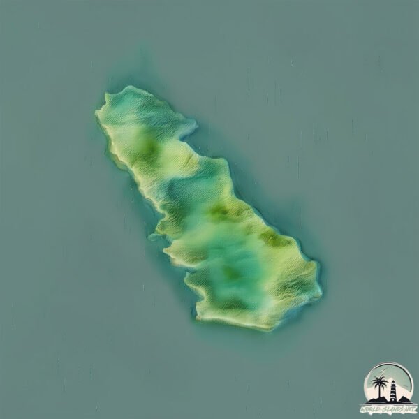
Size: 21.7 km²
Coastline: 30.3 km
Ocean: Atlantic Ocean
Sea: Gulf of Finland
Continent: Europe
Gogland is a Medium Island spanning 22 km² with a coastline of 30 km.
Archipel: –
Tectonic Plate: Eurasia – One of the world’s largest tectonic plates, the Eurasian Plate covers a significant portion of Europe and Asia. It’s characterized by diverse geological features, including the Ural Mountains, the European Plain, and the Himalayas formed from its collision with the Indian Plate.
The geographic heart of the island is pinpointed at these coordinates:
Latitude: 60.05359604 / Longitude: 26.98481377
Climate and weather of Gogland
Climate Zone: Continental
Climate Details: Warm-Summer Humid Continental Climate
Temperature: Warm Summer
Climate Characteristics: Features warm summers and cold winters with consistent precipitation, common in higher latitudes.
Topography and nature of Gogland
Timezone: UTC+04:00
Timezone places: Europe/Moscow
Max. Elevation: 125 m
Mean Elevation: 59 m
Vegetation: Evergreen Needleleaf Forest
Tree Coverage: 92%
The mean elevation is 59 m. The highest elevation on the island reaches approximately 125 meters above sea level. The island is characterized by Plains: Flat, low-lying lands characterized by a maximum elevation of up to 200 meters. On islands, plains are typically coastal lowlands or central flat areas.
Dominating Vegetation: Evergreen Needleleaf Forest
Dominated by evergreen coniferous trees such as pines and firs, which retain their needle-like leaves throughout the year. These forests are often found in cooler climates. Gogland has a tree cover of 92 %.
Vegetation: 6 vegetation zones – Very Highly Diverse Island
Islands in this range are ecological powerhouses, showcasing a wide array of vegetation zones. Each zone, from lush rainforests to arid scrublands, coastal mangroves to mountainous regions, contributes to a complex and interdependent ecosystem. These islands are often hotspots of biodiversity, supporting numerous species and intricate ecological processes.
Infrastructure and Travelling to Gogland
Does the island have a public airport? no.
There is no public and scheduled airport on Gogland. The nearest airport is Lappeenranta Airport, located 167 km away.
Does the island have a major port? no.
There are no major ports on Gogland. The closest major port is KOTKA, approximately 40 km away.
The mean population of Gogland is 29 per km². Gogland is Gently Populated. The island belongs to Russia.
Continuing your journey, Ostrov Moshchnyy is the next notable island, situated merely km away.
loading in gogland island
loading in gogland island
Гогланд 2020. Видеозарисовка №6: "Архипелаг" / Suursaari (Hogland): satellite islands
Остров Гогланд является центром небольшого архипелага, вокруг него ...
Остров Гогланд является центром небольшого архипелага, вокруг него расположено пять небольших островков, ...
2018 09 12 Movie “Going to Gogland”
Coordinatinating Committee of Struve Geodetic Arc, S.Petersburg, 12th ...
Coordinatinating Committee of Struve Geodetic Arc, S.Petersburg, 12th Sept 2018. Movie "Going to Gogland"
Gogland Finland Russia - Analyzing It From Gog & Magog Ya'juj and Ma'juj Perspective
Greetings & Peace, This video explores the island of Gogland, located ...
Greetings & Peace, This video explores the island of Gogland, located in the Gulf of Finland, and its symbolic connections to the ...
Surf on the Gogland island
Putin's visit to the Gogland Island
Гогланд. Океанографическое исследовательское судно Леонид Демин
Не так давно неповторимый рельеф береговой полосы Гогланда «украсил» ...
Не так давно неповторимый рельеф береговой полосы Гогланда «украсил» огромный корпус брошенного ...
На острове Гогланд установлена стела в память о первом сеансе радиосвязи
Памятную стелу установили на острове Гогланд в Балтийском море. Именно ...
Памятную стелу установили на острове Гогланд в Балтийском море. Именно там в 1900 году изобретатель Александр ...
RANKKI MILITARY ISLAND, KOTKA, FINLAND
We had an incredible day on the island, and today we're excited to ...
We had an incredible day on the island, and today we're excited to share it with you! This video will take you on a thrilling journey ...
"Неизвестная Россия": Российский остров между Финляндией и Эстонией
Окруженный кладбищем затонувших кораблей и развалинами военных зданий, ...
Окруженный кладбищем затонувших кораблей и развалинами военных зданий, со стелой в честь первого сеанса ...
Haapasaari island tour Kotka Finland
Haapasaari island trip with Finferry Kotka Finland #finland ...
Haapasaari island trip with Finferry Kotka Finland #finland #beautifulweather #europe #kotka #familytime #beautifulnature #nri ...
Trip to Kotka and Haapasaari Island, DJI Mini 2.
Helped a friend by taking some drone footage of the property that he ...
Helped a friend by taking some drone footage of the property that he is selling in the island . Benefit was to get a short vacation in ...
Гогланд 2017
Небольшой фильм о походе яхты Кондор из Спб на остров Гогланд в июне 2017.
Небольшой фильм о походе яхты Кондор из Спб на остров Гогланд в июне 2017.
Экспедиция "Гогланд-2000" (Expedition "Gogland-2000")
"Экспедиция "Гогланд-2000". Знаменитое измерение Земли 19 века - ...
"Экспедиция "Гогланд-2000". Знаменитое измерение Земли 19 века - транс-европейская "Дуга Струве" - обозначено ...
Гогланд 2019. Видеозарисовка №4: "Хииденкирну" / Suursaari (Hogland): hiidenkirnu
Геологические памятники острова Гогланд.
Геологические памятники острова Гогланд.
Гогланд. Пограничный остров | НЕИЗВЕСТНАЯ РОССИЯ
В самом центре Финского залива обособленной гранитной крепостью стоит ...
В самом центре Финского залива обособленной гранитной крепостью стоит остров Гогланд. Растянувшийся на 11 ...
#остров #Гогланд #граница #снег #балтийскоеморе #seaman #sailor #ship #vessel
Suursaar I
Geolooia Instituudi elspeditsioon Suursaarele tolleaegse Geoloogia ...
Geolooia Instituudi elspeditsioon Suursaarele tolleaegse Geoloogia keskise meregeoloogia laeva "Marinaga" (vist 198? aastal).
Остров Гогланд
Остров Гогланд.
Остров Гогланд.
Путин на острове Гогланд ч. 1/3
Встреча с участниками экспедиции «Гогланд-2013» 15 июля 2013 года ...
Встреча с участниками экспедиции «Гогланд-2013» 15 июля 2013 года Владимир Путин посетил остров Гогланд в Финском ...
Conquering Gogland Island | Arma Reforger
We load into WCS servers to play some modern combat. This whole game ...
We load into WCS servers to play some modern combat. This whole game was well over 6 hours long but I cut it down to less than ...
Гогланд 2021. Видеозарисовка №8: "Весна в Киискинкюля"/ Suursaari (Hogland): spring in Kiiskinkylä
Видео-реквием по островной финской деревеньке, не пережившей ...
Видео-реквием по островной финской деревеньке, не пережившей присоединения к СССР.
Гогланд. Океанографическое исследовательское судно Леонид Демин
Не так давно неповторимый рельеф береговой полосы Гогланда «украсил» ...
Не так давно неповторимый рельеф береговой полосы Гогланда «украсил» огромный корпус брошенного ...
Гогланд остров 2019 год корабль Демина
Russia is classified as Emerging region: BRIC: Brazil, Russia, India, and China – Economies noted for their rapid growth and increasing influence on global affairs. The level of income is Upper middle income.
News – Latest Updates and Headlines from Gogland
Stay informed with the most recent news and important headlines from Gogland. Here’s a roundup of the latest developments.
Loading...
Please note: The data used here has been primarily extracted from satellite readings. Deviations from exact values may occur, particularly regarding the height of elevations and population density. Land area and coastline measurements refer to average values at mean high tide.