Graciosa Island
Welcome to Graciosa Island, a Dry island in the North Atlantic Ocean, part of the majestic Atlantic Ocean. This guide offers a comprehensive overview of what makes Graciosa Island unique – from its geography and climate to its population, infrastructure, and beyond. Dive into the details:
- Geography and Size: Explore the island’s size and location.
- Climate and Weather: Weather patterns and temperature.
- Topography and Nature: Uncover the natural wonders of the island.
- Infrastructure and Travelling: Insights on reaching, staying, and making the most of your visit.
- News and Headlines: Latest News.
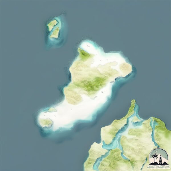
Geography and size of Graciosa Island
Size: 28.6 km²
Coastline: 30.2 km
Ocean: Atlantic Ocean
Sea: North Atlantic Ocean
Continent: Africa
Graciosa Island is a Medium Island spanning 29 km² with a coastline of 30 km.
Archipel: Canary Islands – A Spanish archipelago off the coast of northwestern Africa, known for their volcanic landscapes, unique ecosystems, and vibrant cultures.
Tectonic Plate: North America – Covers North America and parts of the Atlantic and Arctic Oceans, characterized by diverse geological features and varying levels of seismic activity.
The geographic heart of the island is pinpointed at these coordinates:
Latitude: 29.25221702 / Longitude: -13.50892941
Climate and weather of Graciosa Island
Climate Zone: Dry
Climate Details: Hot Deserts Climate
Temperature: Hot
Climate Characteristics: Dominated by extremely hot temperatures, this climate is marked by minimal rainfall and barren landscapes. Nights often experience drastic temperature drops.
Topography and nature of Graciosa Island
Timezone: UTC±00:00
Timezone places: Europe/Lisbon
Max. Elevation: 190 m
Mean Elevation: 37 m
Vegetation: Sparse Vegetation
Tree Coverage: 14%
The mean elevation is 37 m. The highest elevation on the island reaches approximately 190 meters above sea level. The island is characterized by Plains: Flat, low-lying lands characterized by a maximum elevation of up to 200 meters. On islands, plains are typically coastal lowlands or central flat areas.
Dominating Vegetation: Sparse Vegetation
These regions have limited plant growth, typically due to extreme conditions like aridity or poor soils. Vegetation is scattered and consists of hardy plant species. Graciosa Island has a tree cover of 14 %.
Vegetation: 5 vegetation zones – Highly Diverse Island
With five different vegetation zones, these islands offer a rich tapestry of ecosystems. The variety could include dense forests, open meadows, wetlands, coastal zones, and more. This level of diversity supports an intricate web of life, with each zone playing a vital role in the overall ecological health and balance of the island.
Infrastructure and Travelling to Graciosa Island
Does the island have a public airport? no.
There is no public and scheduled airport on Graciosa Island. The nearest airport is César Manrique-Lanzarote Airport, located 31 km away.
Does the island have a major port? no.
There are no major ports on Graciosa Island. The closest major port is ARRECIFE, approximately 30 km away.
The mean population of Graciosa Island is 90 per km². Graciosa Island is Gently Populated. The island belongs to Spain.
Continuing your journey, Isla de Alegranza is the next notable island, situated merely km away.
Escape to Authentic: Graciosa Island


Spain is classified as Developed region: nonG7: Developed economies outside of the Group of Seven, characterized by high income and advanced economic structures. The level of income is High income: OECD.
News – Latest Updates and Headlines from Graciosa Island
Stay informed with the most recent news and important headlines from Graciosa Island. Here’s a roundup of the latest developments.
Please note: The data used here has been primarily extracted from satellite readings. Deviations from exact values may occur, particularly regarding the height of elevations and population density. Land area and coastline measurements refer to average values at mean high tide.