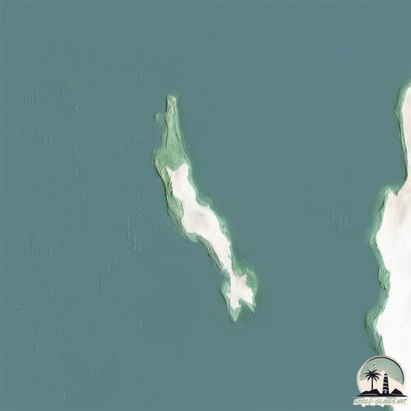
Welcome to Graget, a Temperate island in the South Atlantic Ocean, part of the majestic Atlantic Ocean. This guide offers a comprehensive overview of what makes Graget unique – from its geography and climate to its population, infrastructure, and beyond. Dive into the details:
Geography and size of Graget
Size: 1.889 km²
Coastline: 13.5 km
Ocean: Atlantic Ocean
Sea: South Atlantic Ocean
Continent: Africa
Graget is a Small Island spanning 1.9 km² with a coastline of 13.5 km.
Archipel: –
Tectonic Plate: Somalia – A large tectonic plate covering the Horn of Africa and parts of the Indian Ocean, known for the East African Rift where it’s splitting away from the African Plate.
The geographic heart of the island is pinpointed at these coordinates:
Latitude: -27.01348751 / Longitude: 15.19431107
Climate and weather of Graget
Climate Zone: Temperate
Climate Details: Warm-Summer Mediterranean Climate
Temperature: Warm Summer
Climate Characteristics: Characterized by warm, dry summers and mild, wet winters, typical of coastal areas with abundant sunshine Rain is more common in the winter months, maintaining a moderate climate.
Topography and nature of Graget
Timezone: UTC+01:00
Timezone places: Europe/Paris
Max. Elevation: 2 m
Mean Elevation: -2 m
Vegetation: Sparse Vegetation with Trees/Shrubs
Tree Coverage: 57%
The mean elevation is -2 m. The highest elevation on the island reaches approximately 2 meters above sea level. The island is characterized by Plains: Flat, low-lying lands characterized by a maximum elevation of up to 200 meters. On islands, plains are typically coastal lowlands or central flat areas.
Dominating Vegetation: Sparse Vegetation with Trees/Shrubs
Areas where grasses and other herbaceous plants are prevalent, but with occasional presence of trees and shrubs. Often found in semi-arid regions or grasslands. Graget has a tree cover of 57 %.
Vegetation: 2 vegetation zones – Low Diversity Island
Islands with two distinct vegetation zones offer slightly more ecological variety. These zones could be due to differences in elevation, moisture, or other environmental factors. While still limited in biodiversity, these islands may offer a contrast between the two zones, such as a coastline with mangroves and an inland area with grassland.
Infrastructure and Travelling to Graget
Does the island have a public airport? no.
There is no public and scheduled airport on Graget. The nearest airport is Luderitz Airport, located 34 km away.
Does the island have a major port? no.
There are no major ports on Graget. The closest major port is LUDERITZ BAY, approximately 38 km away.
The mean population of Graget is 0 per km². Graget is Uninhabited. The island belongs to Namibia.
Continuing your journey, Ilha dos Tigres is the next notable island, situated merely km away.
$70 Polystone Poké Ball from Legends Arceus
$70 Polystone Poké Ball from Legends Arceus
Inspector Gadget 140 - Pirate Island | HD | Full Episode
Inspector Gadget 140 - Pirate Island | HD | Full Episode Dr. Claw is ...
Inspector Gadget 140 - Pirate Island | HD | Full Episode Dr. Claw is kidnapping billionaires and stealing their money. Inspector ...
DYNAMIC ISLAND SECRET FEATURE 🔐
7 MORE Ways to Use the Dynamic Island
Here are 7 more actually useful ways you can use the Dynamic Island on ...
Here are 7 more actually useful ways you can use the Dynamic Island on the iPhone 16 (all models), iPhone 15 (all models) and ...
Gadget and the Gadgetinis EP19S1-Unpleasant Island 4K Ultra HD
Gadget and the Gadgetinis EP19S1-Unpleasant Island 4K Ultra HD.
Gadget and the Gadgetinis EP19S1-Unpleasant Island 4K Ultra HD.
Bedside Water Dispenser Review #shorts #amazonfinds #productreview #gadget #lifehacks
I Bought the Cheapest Spy Contact Lenses #shorts #shortvideo #gadgets
I Bought the Cheapest Spy Contact Lenses #shorts #shortvideo #gadgets ...
I Bought the Cheapest Spy Contact Lenses #shorts #shortvideo #gadgets shorts video | shorts | short | short video | viral videos ...
Inspector Gadget 140 - Pirate Island (Full Episode)
Dr. Claw is kidnapping billionaires and stealing their money. ...
Dr. Claw is kidnapping billionaires and stealing their money. Inspector Gadget rescues the captured billionaires and protects their ...
New Gadget Cache Amongst the Rare Birds of Tiritiri Matangi Island
This weeks Cache Walk is about putting a new gadget cache out on ...
This weeks Cache Walk is about putting a new gadget cache out on Tiritiri Matangi Island. Come and see the second geocache to ...
5 Ways to ACTUALLY Use the Dynamic Island
Don't know what to make of Dynamic Island? Nor did I until I came ...
Don't know what to make of Dynamic Island? Nor did I until I came across these 5 neat apps that utilise lonely Island!
I visited Secret island in Japan II Indian in Japan II
Click the link in the description and use the code AJAY50 to get 50% ...
Click the link in the description and use the code AJAY50 to get 50% off for 2 months.
Survival lifehack #bushcraft #camping #outdoors #survival #forest #lifehacks
NEW VIDEO, ALMOST EVERYDAY!! SUBSCRIBE ME!! @bokoch FROM YOU LIKE AND ...
NEW VIDEO, ALMOST EVERYDAY!! SUBSCRIBE ME!! @bokoch FROM YOU LIKE AND COMMENT ...
Unlock the BEST Item 🎁 PROPELLER HAT 🎩 in Wobbly Life #shorts
I spent 3 HOURS trying to get this item... THIS Propeller Hat is one ...
I spent 3 HOURS trying to get this item... THIS Propeller Hat is one of the HARDEST items to get in Wobbly Life! It's the BEST way ...
Pirate Island 🔍 Inspector Gadget | Full Episode | Season One | Classic Cartoons
Pirate Island Inspector Gadget ▻ Click to subscribe: ...
Pirate Island Inspector Gadget ▻ Click to subscribe:
http://bit.ly/21cyjpV Gadget is on vacation on a cruise in the Caribbean, ...
Mystery Cave and Swimming Pigs (The cave goes under the island!)
In the Exuma Islands of the Bahamas, Jonathan and Cameraman Zach ...
In the Exuma Islands of the Bahamas, Jonathan and Cameraman Zach explore an ocean cave that extends under an island!
Why we NEEDED the Iphone 15 Dynamic Island
Why we NEEDED the Iphone 15 Dynamic Island Subscribe for more tech ...
Why we NEEDED the Iphone 15 Dynamic Island Subscribe for more tech commentary, reviews, and news. #carterpcs #tech ...
How To Breed Gjoob in My Singing Monsters!
For Watching Please Subscribe if you Enjoyed! Follow Me On Instagram!- ...
For Watching Please Subscribe if you Enjoyed! Follow Me On Instagram!- / ethan.armstrong_ Follow Me On Twitter- / ethanpure_ ...
The Only Travel Adapter You Need!
If you're a traveller or you carry your charging adapters, this Travel ...
If you're a traveller or you carry your charging adapters, this Travel adapter will make a lot of sense to you. This has pins for all the ...
How To Breed Ghazt in My Singing Monsters!
How To Breed Ghazt in My Singing Monsters! my singing monsters,my ...
How To Breed Ghazt in My Singing Monsters! my singing monsters,my singing monsters ghazt,my singing monsters how to breed ...
Inspector Gadget 140 - Pirate Island | HD | Full Episode
Inspector Gadget 140 - Pirate Island | HD | Full Episode Dr. Claw is ...
Inspector Gadget 140 - Pirate Island | HD | Full Episode Dr. Claw is kidnapping billionaires and stealing their money. Inspector ...
who choose the best gadget on the Island? #phonk #music #anime #truphone #bananaphone
Inspector Gadget 115 - Volcano Island (Gadget Goes Hawaiian) | HD | Full Episode
Inspector Gadget 115 - Volcano Island (Gadget Goes Hawaiian) | HD | ...
Inspector Gadget 115 - Volcano Island (Gadget Goes Hawaiian) | HD | Full Episode Inspector Gadget, Penny and Brain while on ...
Mac finally has Dynamic Island?! 🤯
How to Set Dynamic Island in series9 clone smartwatch 😳✅⌚️#shorts #series9
Model name - WS- Sx9 Series 9, amoled display, Dynamic Island, Gesture ...
Model name - WS- Sx9 Series 9, amoled display, Dynamic Island, Gesture control, calculator, game, Bluetooth calling.
Stealth Camping At Bribie Island Beach Stealth Camping Alliance Gadget Challenge
stealthcampingalliance #stealthgadget SCA August 2023 Challenge today ...
stealthcampingalliance #stealthgadget SCA August 2023 Challenge today we did a stealth camp on Bribie Island in Queensland ...
Namibia is classified as Developing region: Regions characterized by lower income levels, with economies in the process of industrialization and modernization. The level of income is Upper middle income.
News – Latest Updates and Headlines from Graget
Stay informed with the most recent news and important headlines from Graget. Here’s a roundup of the latest developments.
Loading...
Please note: The data used here has been primarily extracted from satellite readings. Deviations from exact values may occur, particularly regarding the height of elevations and population density. Land area and coastline measurements refer to average values at mean high tide.