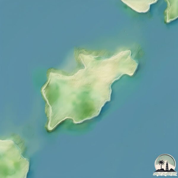
Welcome to Graham, a Temperate island in the The Northwestern Passages, part of the majestic Pacific Ocean. This guide offers a comprehensive overview of what makes Graham unique – from its geography and climate to its population, infrastructure, and beyond. Dive into the details:
Geography and size of Graham
Size: 6552 km²
Coastline: 1802 km
Ocean: Pacific Ocean
Sea: The Northwestern Passages
Continent: North America
Graham is a Very Large Island spanning 6552 km² with a coastline of 1802 km.
Archipel: Haida Gwaii – An archipelago off the northern coast of British Columbia, Canada, known for its rich indigenous Haida culture and lush, temperate rainforests.
Tectonic Plate: North America – Covers North America and parts of the Atlantic and Arctic Oceans, characterized by diverse geological features and varying levels of seismic activity.
The geographic heart of the island is pinpointed at these coordinates:
Latitude: 62.33916389 / Longitude: -117.16628084
Climate and weather of Graham
Climate Zone: Temperate
Climate Details: Temperate Oceanic Climate
Temperature: Warm Summer
Climate Characteristics: Known for its moderate year-round temperatures with ample rainfall and no dry season. Warm summers are characteristic.
Topography and nature of Graham
Timezone: UTC-08:00
Timezone places: America/Los_Angeles
Max. Elevation: 169 m
Mean Elevation: 52 m
Vegetation: Evergreen Needleleaf Forest
Tree Coverage: 45%
The mean elevation is 52 m. The highest elevation on the island reaches approximately 169 meters above sea level. The island is characterized by Plains: Flat, low-lying lands characterized by a maximum elevation of up to 200 meters. On islands, plains are typically coastal lowlands or central flat areas.
Dominating Vegetation: Evergreen Needleleaf Forest
Dominated by evergreen coniferous trees such as pines and firs, which retain their needle-like leaves throughout the year. These forests are often found in cooler climates. Graham has a tree cover of 45 %.
Vegetation: 15 vegetation zones – Exceptionally Diverse Island
Islands with more than ten vegetation zones are among the most ecologically rich and varied in the world. These islands are akin to miniature continents, boasting an incredible array of ecosystems. The sheer range of habitats, from high peaks to deep valleys, rainforests to deserts, creates a mosaic of life that is unparalleled. They are crucial for conservation and ecological studies.
Infrastructure and Travelling to Graham
Does the island have a public airport? yes.
Graham has a public and scheduled airport. The following airports are located on this island: Masset Airport.
Does the island have a major port? yes.
Graham is home to a major port. The following ports are situated on the island: MASSET HARBOR, PORT CLEMENTS.
The mean population of Graham is 0 per km². Graham is Uninhabited. The island belongs to Canada.
Continuing your journey, Maude is the next notable island, situated merely km away.
Graham Island and Ye Starbucks: Citation Needed 4x01
We're back! And back where we belong, too, in a kitchen with dodgy lighting. Time for a new run of five episodes, and our ...Graham Island and Ye Starbucks: Citation Needed 4x01
We're back! And back where we belong, too, in a kitchen with dodgy ...
We're back! And back where we belong, too, in a kitchen with dodgy lighting. Time for a new run of five episodes, and our ...
British Columbias Mysterious Northern Islands | Destination Adventure
Haida Gwaii has always been a dream of mine to visit. It is remote, ...
Haida Gwaii has always been a dream of mine to visit. It is remote, hard to access, rarely visited and most of all, rich in history.
The Vanishing Island: The True Mystery of Graham Island
What if I told you there's an island that appears and disappears, ...
What if I told you there's an island that appears and disappears, playing hide-and-seek with the Mediterranean? Welcome to the ...
The Mediterranean Island That Disappeared
In 1831, an island mysteriously rose from the Mediterranean Sea off ...
In 1831, an island mysteriously rose from the Mediterranean Sea off the coast of Sicily — and almost sparked a major international ...
3 Days on Graham Island, Haida Gwaii. British Columbia by Motorhome ep. 7
In this episode, we spend 3 days on Graham Island, the largest of the ...
In this episode, we spend 3 days on Graham Island, the largest of the Haida Gwaii archipelago. We are northwest of the Canadian ...
Discover the perfect getaway at Grahams Island State Park
Nestled in the heart of Devils Lake, Grahams Island State Park is the ...
Nestled in the heart of Devils Lake, Grahams Island State Park is the perfect destination for fishing, relaxation, and outdoor fun ...
Port Louis BC on the West coast of Graham Island of the Haida Gwaii
Graham Island: The island that sank
Edited on iMovie via YouTube Capture.
Edited on iMovie via YouTube Capture.
Graham Island, Haida Gwaii. Naikoon Park. BC #shorts
North of Graham Island, the largest island in the Haida Gwaii ...
North of Graham Island, the largest island in the Haida Gwaii archipelago in British Columbia, Canada. Here it overlooks the ...
Explore the magical islands of Haida Gwaii and delve into Haida culture, art & history.
A long anticipated journey to the amazing islands of Haida Gwaii off ...
A long anticipated journey to the amazing islands of Haida Gwaii off the British Columbia Coast. @RoadsRivers 3 weeks ...
Graham’s Island
Here's a 9/4 song. Speaking of 9/4... Here's who's who! Quibble-Bloo ...
Here's a 9/4 song. Speaking of 9/4... Here's who's who! Quibble-Bloo Kid Reedling-Eddie Rare Pango-Martin Quarrister-Dibblers ...
Graham: “Who gives a shit who owns Greenland?”
Sen. Lindsey Graham (R-SC) on Friday urged European leaders to move ...
Sen. Lindsey Graham (R-SC) on Friday urged European leaders to move past President Trump's push for the U.S. to acquire ...
On The Island
Provided to YouTube by DistroKid On The Island · Colin Graham On The ...
Provided to YouTube by DistroKid On The Island · Colin Graham On The Island ℗ Colin Graham Released on: 2024-05-31 ...
The Island That Keeps Appearing and Disappearing
Sign up for a CuriosityStream subscription and also get a free Nebula ...
Sign up for a CuriosityStream subscription and also get a free Nebula subscription (the new streaming platform built by creators) ...
Graham Nash - Out On The Island (with lyrics) 1980
Sky was full of diamonds some of them were falling Cloud came by and ...
Sky was full of diamonds some of them were falling Cloud came by and covered up the skyline Voices in the distance, I could ...
The Enigma of Graham Island
Explore the mystery of Graham Island, the ephemeral landmass that ...
Explore the mystery of Graham Island, the ephemeral landmass that emerged from the depths of the Mediterranean Sea. Join us ...
The *DISAPPEARING VOLCANIC ISLAND*; Graham Island in the Sicily Channel #island #volcano #lost #lava
only Graham Bell is allowed in this island💀💀 #edit #map #maps #geography
Queen Charlotte Haida Indians Narrarted by Duane Foerter
Award-Winning Writer/Photographer/Videographer, Bill Vanderford ...
Award-Winning Writer/Photographer/Videographer, Bill Vanderford (www.fishinglanier.com), presents a look at the history of the ...
Graham island
A nice trip on the ferry to Masset.BC.
A nice trip on the ferry to Masset.BC.
Masset to Langara Island (Includes Naden Harbour) north coast of Graham Island
These videos are of a coastal aerial video imaging (AVI) survey ...
These videos are of a coastal aerial video imaging (AVI) survey conducted in the Queen Charlotte Islands during 1997 from ...
HY-Brasil: Ireland's Atlantis? 👀 (Featuring Graham Hancock and Joe Rogan)
irishmythology #hybrasil #ireland Buy me a Coffee: ...
Motorcycling remote islands you didn’t know existed in Canada 🇨🇦 |S6-E127|
In this episode, I am exploring the large, northern island of Haida ...
In this episode, I am exploring the large, northern island of Haida Gwaii: Grahams Island. This island is full of deer, bears and ...
Graham Island State Park
July 18, 2022 - Graham Island State Park in Devils Lake, North Dakota. ...
July 18, 2022 - Graham Island State Park in Devils Lake, North Dakota. Located on a small island in the middle of the lake, this is ...
Canada is classified as Developed region: G7: Group of Seven – Major advanced economies, including Canada, France, Germany, Italy, Japan, the United Kingdom, and the United States. The level of income is High income: OECD.
News – Latest Updates and Headlines from Graham
Stay informed with the most recent news and important headlines from Graham. Here’s a roundup of the latest developments.
Loading...
Social Media Posts about Graham
Loading...
Please note: The data used here has been primarily extracted from satellite readings. Deviations from exact values may occur, particularly regarding the height of elevations and population density. Land area and coastline measurements refer to average values at mean high tide.