Welcome to Gran Canaria, a Dry island in the North Atlantic Ocean, part of the majestic Atlantic Ocean. This guide offers a comprehensive overview of what makes Gran Canaria unique – from its geography and climate to its population, infrastructure, and beyond. Dive into the details:
Geography and size of Gran Canaria
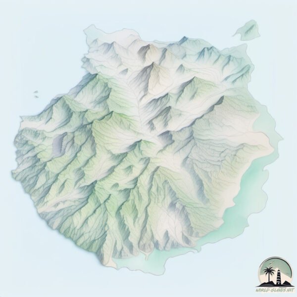
Size: 1566 km²
Coastline: 231 km
Ocean: Atlantic Ocean
Sea: North Atlantic Ocean
Continent: Africa
Gran Canaria is a Very Large Island spanning 1566 km² with a coastline of 231 km.
Archipel: Canary Islands – A Spanish archipelago off the coast of northwestern Africa, known for their volcanic landscapes, unique ecosystems, and vibrant cultures.
Tectonic Plate: Africa – One of the world’s largest tectonic plates, covering the African continent and parts of the surrounding oceans, known for its stability with some active rift zones.
The geographic heart of the island is pinpointed at these coordinates:
Latitude: 27.95549446 / Longitude: -15.59329806
Climate and weather of Gran Canaria
Climate Zone: Dry
Climate Details: Hot Semi-Arid (Steppe) Climate
Temperature: Hot
Climate Characteristics: Features hot summers and mild to warm winters. Receives more rainfall than hot deserts but less than tropical savannas, leading to a somewhat more varied landscape.
Topography and nature of Gran Canaria
Timezone: UTC±00:00
Timezone places: Europe/Lisbon
Max. Elevation: 1949 m Pico de las Nieves
Mean Elevation: 528 m
Vegetation: Shrubland
Tree Coverage: 11%
The mean elevation is 528 m. Dominating the island’s landscape, the majestic “Pico de las Nieves” rises as the highest peak, soaring to impressive heights. The island is characterized by Mountains: High, steeply elevated landforms. Characterized by both a high maximum elevation (over 500 meters) and a high mean elevation, creating rugged, mountainous terrains on islands.
Dominating Vegetation: Shrubland
Dominated by shrubs and small bushes, these areas are typical in dry, rocky, or sandy environments, as well as in regions with poor soil fertility. Gran Canaria has a tree cover of 11 %.
Vegetation: 13 vegetation zones – Exceptionally Diverse Island
Islands with more than ten vegetation zones are among the most ecologically rich and varied in the world. These islands are akin to miniature continents, boasting an incredible array of ecosystems. The sheer range of habitats, from high peaks to deep valleys, rainforests to deserts, creates a mosaic of life that is unparalleled. They are crucial for conservation and ecological studies.
Infrastructure and Travelling to Gran Canaria
Does the island have a public airport? yes.
Gran Canaria has a public and scheduled airport. The following airports are located on this island: Gran Canaria Airport.
Does the island have a major port? yes.
Gran Canaria is home to a major port. The following ports are situated on the island: LAS PALMAS.
The mean population of Gran Canaria is 641 per km². Gran Canaria is Densely Populated. The island belongs to Spain.
The name of the island resonates across different cultures and languages. Here is how it is known around the world: Arabic: كناريا الكبرى; German: Gran Canaria; Spanish: Gran Canaria; French: Grande Canarie; Portuguese: Grã Canária; Russian: Гран-Канария; Chinese: 大加那利岛
Continuing your journey, Tenerife is the next notable island, situated merely km away.
TOP 15 Things To Do In Gran Canaria 🇪🇸 Travel Guide
Gran Canaria, part of the Canary Islands, offers a rich blend of stunning landscapes, vibrant culture, and a multitude of activities ...TOP 15 Things To Do In Gran Canaria 🇪🇸 Travel Guide
Gran Canaria, part of the Canary Islands, offers a rich blend of ...
Gran Canaria, part of the Canary Islands, offers a rich blend of stunning landscapes, vibrant culture, and a multitude of activities ...
Gran Canaria: The Best Areas to Stay & Visit in 2026... 🏝️
In this quick overview, we travel around the Spanish island of Gran ...
In this quick overview, we travel around the Spanish island of Gran Canaria to check out some of the best areas to stay and visit!
Tenerife vs Gran Canaria | What is the BEST Canary island to visit?
You want to go to the Canary Islands, but wonder if Tenerife or Gran ...
You want to go to the Canary Islands, but wonder if Tenerife or Gran Canaria is the best island to visit? This video covers ...
17 Best Things to do in Gran Canaria, Spain (Canary Islands)
For MORE things to do in Gran Canaria, VISIT ...
Las Palmas Gran Canaria Travel Guide: 13 BEST Things To Do In Las Palmas, Spain
How to find cheap flights and travel more: ...
Gran Canaria Travel Guide 2025: All The Best Places 🇪🇦🌴
I apologize for the bad sound in by the 2nd half of the video. I hade ...
I apologize for the bad sound in by the 2nd half of the video. I hade to change it due to copyright claims -. Looking for beaches and ...
Wonders of Gran Canaria | Best Places to Visit in Gran Canaria | Travel Video 4K
Wonders of Gran Canaria | Best Places to Visit in Gran Canaria | ...
Wonders of Gran Canaria | Best Places to Visit in Gran Canaria | Travel Video 4K Subscribe to the channel here, it's free but ...
20 of the Best Places to Visit in Gran Canaria - 4K Travel Guide
We've just returned from an incredible 10-day trip to Gran Canaria and ...
We've just returned from an incredible 10-day trip to Gran Canaria and were impressed by how diverse, tropical and unique the ...
Gran Canaria | Why it’s ALMOST the Best Island in the World & The Missing 3%
Is Gran Canaria really one of the world's best islands? In our travel ...
Is Gran Canaria really one of the world's best islands? In our travel series documenting the Canary Islands, we go beyond the ...
FIRST TIME IN GRAN CANARIA! 🇪🇸 CANARY ISLANDS (SPAIN)
Get 5% OFF on the Holafly eSIM and have unlimited data for your trip ...
Gran Canaria - 30 Best Places to Visit [2026]
Support the channel & get our Living European Travel Guide (50% Off) ...
Canary Islands Vacation Travel Guide | Expedia
The Canary Islands – a magical archipelago of cultural, historical and ...
The Canary Islands – a magical archipelago of cultural, historical and geological importance. Discover the best places to visit and ...
Gran Canaria Travel Guide | Top 18 Places to Visit in 2026 (4K)
We spent a full week traveling across Gran Canaria, filming a ...
We spent a full week traveling across Gran Canaria, filming a documentary-style slow travel film that captures the island's real ...
Why You SHOULD Visit Gran Canaria - Island Tour
Join me on this adventure around the island of Gran Canaria, situated ...
Join me on this adventure around the island of Gran Canaria, situated off northwestern Africa. It's known for its black lava and ...
2 of 5 TOP PLAYAS IN GRAN CANARIA🏝️ #canaryislands #grancanaria #travel #travelguide #viaggio
You have to visit this place in Gran Canaria
Puerto de Mógan is such a wonderful village in Gran Canaria Follow ...
Puerto de Mógan is such a wonderful village in Gran Canaria Follow @7people7wonders for more.
Where to stay in Gran Canaria: Best Areas to Stay in Gran Canaria, Spain
Where to stay in Gran Canaria, Spain? What are the best areas to stay ...
Where to stay in Gran Canaria, Spain? What are the best areas to stay in Gran Canaria? It's a question that many people ask ...
Gran Canaria floods wash car out to sea
Heavy rain and flash floods in the Canary Islands have washed cars out ...
Heavy rain and flash floods in the Canary Islands have washed cars out to sea and left people trapped indoors. [Subscribe: ...
Places in Canary Islands that don’t feel real 🇮🇨🤯 #travel #adventure #nature #canaryislands
Puerto de Mogán, Gran Canaria – The Venice of the Canary Islands 4K
Puerto de Mogán isn't just a resort! In this travel guide, we explore ...
Puerto de Mogán isn't just a resort! In this travel guide, we explore the charming marina of Puerto Mogán — its colorful houses, ...
Gran Canaria in Winter: Swim in Paradise? ☀️🌊🌴 #GranCanaria #WinterSun #Paradise #Beach #Travel
Dreaming of warm beaches this winter? Gran Canaria might be your ...
Dreaming of warm beaches this winter? Gran Canaria might be your answer! This stunning beach is the perfect place to escape ...
7 Amazing Places You Must See in Gran Canaria
Add these 7 Amazing Places You Must See in Gran Canaria🏝️⛵️ 🗺️ In this ...
Add these 7 Amazing Places You Must See in Gran Canaria🏝️⛵️ 🗺️ In this guide, you'll discover: Iconic natural ...
Gran Canaria Travel Guide 2025 🇮🇨 Top Attractions + Secret Spots
Imagine a land where lush green forest gives way to vast deserts and ...
Imagine a land where lush green forest gives way to vast deserts and volcanic peaks. Where pastel hued villages dot the ...
BEST Canary Island for you? - TRAVEL GUIDE | Tenerife, Lanzarote, Gran Canaria, or Fuerteventura?
Which Canary Island should you visit? In this detailed Canary Islands ...
Which Canary Island should you visit? In this detailed Canary Islands travel guide, we compare Tenerife, Fuerteventura, Gran ...
Gran Canaria 4K | Drone | Canary Islands
Last month, I discovered the beautiful island of Gran Canaria. Let me ...
Last month, I discovered the beautiful island of Gran Canaria. Let me present you some of the prettiest spots I found along the ...
Spain is classified as Developed region: nonG7: Developed economies outside of the Group of Seven, characterized by high income and advanced economic structures. The level of income is High income: OECD.
News – Latest Updates and Headlines from Gran Canaria
Stay informed with the most recent news and important headlines from Gran Canaria. Here’s a roundup of the latest developments.
Loading...
Social Media Posts about Gran Canaria
Loading...
Please note: The data used here has been primarily extracted from satellite readings. Deviations from exact values may occur, particularly regarding the height of elevations and population density. Land area and coastline measurements refer to average values at mean high tide.


![Gran Canaria - 30 Best Places to Visit [2026]](https://i.ytimg.com/vi/YQzHnbonsRA/mqdefault.jpg)