Welcome to Gran Roque, a Dry island in the Caribbean Sea, part of the majestic Atlantic Ocean. This guide offers a comprehensive overview of what makes Gran Roque unique – from its geography and climate to its population, infrastructure, and beyond. Dive into the details:
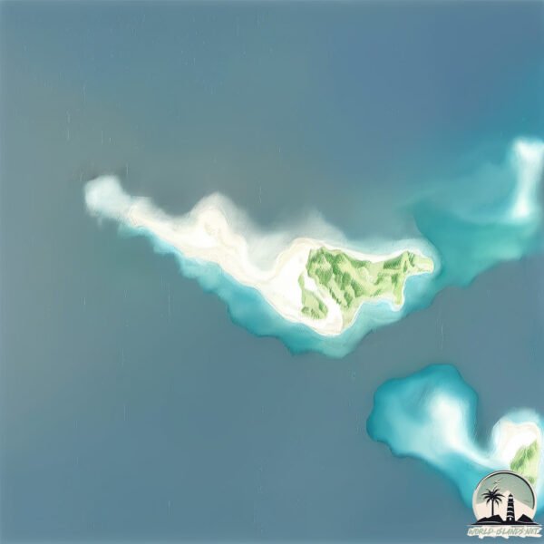
Geography and size of Gran Roque
Size: 1.507 km²
Coastline: 8.4 km
Ocean: Atlantic Ocean
Sea: Caribbean Sea
Continent: North America
Gran Roque is a Small Island spanning 1.5 km² with a coastline of 8.4 km.
Archipel: Lesser Antilles – A long arc of small islands in the Caribbean Sea, stretching from the Virgin Islands to Trinidad, known for their distinct cultures and tropical landscapes.
Tectonic Plate: Caribbean – Covering the Caribbean Sea and surrounding regions, this plate is bordered by the North American Plate and the South American Plate. Known for seismic activity, including earthquakes and volcanic eruptions, and features like the Puerto Rico Trench.
The geographic heart of the island is pinpointed at these coordinates:
Latitude: 11.95002197 / Longitude: -66.67639117
Climate and weather of Gran Roque
Climate Zone: Dry
Climate Details: Hot Semi-Arid (Steppe) Climate
Temperature: Hot
Climate Characteristics: Features hot summers and mild to warm winters. Receives more rainfall than hot deserts but less than tropical savannas, leading to a somewhat more varied landscape.
Topography and nature of Gran Roque
Timezone: UTC-04:30
Timezone places: America/Caracas
Max. Elevation: 7 m
Mean Elevation: 5 m
Vegetation: Wetland
Tree Coverage: 76%
The mean elevation is 5 m. The highest elevation on the island reaches approximately 7 meters above sea level. The island is characterized by Plains: Flat, low-lying lands characterized by a maximum elevation of up to 200 meters. On islands, plains are typically coastal lowlands or central flat areas.
Dominating Vegetation: Wetland
These areas are saturated with water, either permanently or seasonally, and support aquatic plants. Wetlands are important for biodiversity and water filtration. Gran Roque has a tree cover of 76 %.
Vegetation: 4 vegetation zones – Diverse Island
Four distinct vegetation zones mark these islands as ecologically diverse. They might feature varied landscapes such as forests, beaches, grasslands, and rocky areas. Such diversity reflects the island’s complex ecological interactions and varied habitats, which can support a rich array of wildlife and plant species.
Infrastructure and Travelling to Gran Roque
Does the island have a public airport? yes.
Gran Roque has a public and scheduled airport. The following airports are located on this island: Los Roques Airport.
Does the island have a major port? no.
There are no major ports on Gran Roque. The closest major port is LA GUAIRA, approximately 150 km away.
The mean population of Gran Roque is 12 per km². Gran Roque is Gently Populated. The island belongs to Venezuela.
Continuing your journey, La Orchila is the next notable island, situated merely km away.
Los Roques Venezuela - The Most beautiful beach in the world
Los Roques is seriously beautiful. Located 85 miles off Venezuela's mainland Los Roques is considered one of the most beautiful ...Los Roques Venezuela - The Most beautiful beach in the world
Los Roques is seriously beautiful. Located 85 miles off Venezuela's ...
Los Roques is seriously beautiful. Located 85 miles off Venezuela's mainland Los Roques is considered one of the most beautiful ...
Paradise in Los Roques, Venezuela | Best Places to visit in Venezuela |
🏝️🇻🇪 Discovering Paradise: Venezuela's Los Roques Islands - A Tropical Haven! 🌴🌞
Los Roques Islands, Venezuela, Caribbean Paradise, Tropical Haven, ...
Los Roques Islands, Venezuela, Caribbean Paradise, Tropical Haven, Vacation Destination, Pristine Beaches, Crystal-Clear ...
Venezuela - Los Roques island and national park - 1993
Los Roques island Venezuela First shown: 08/02/1993 If you would like ...
Los Roques island Venezuela First shown: 08/02/1993 If you would like to license a clip from this video please e mail: ...
Los Roques Venezuela - The most beautiful island in Venezuela
Venezuela Is the Future — Los Roques: The New Maldives Despite ...
Venezuela Is the Future — Los Roques: The New Maldives Despite everything Venezuela has gone through recently, ...
Trekking en el Faro de el Gran Roque - Venezuela - Ponton Trips
Tuve la oportunidad de ir a esta nueva aventura, subir caminando a uno ...
Tuve la oportunidad de ir a esta nueva aventura, subir caminando a uno de los faros más altos en el Archipiélago de Los Roques ...
Bajo Pepita, Los Roques, Venezuela #bestvacations #bestplacestogo #caribbean #beach #dji #drone
Gran Roque (Memorable Sailing) Ep 43
Isla El Gran (Los Roques) is the most populated Island out of the 350 ...
Isla El Gran (Los Roques) is the most populated Island out of the 350 Islands. They received 70000 visitors a year from the ...
Conoces este paraíso? LOS ROQUES Venezuela
Menuda experiencia vivida en estas islas y cayos, 🏝️con la gran ...
Menuda experiencia vivida en estas islas y cayos, 🏝️con la gran acogida de Enrique, Edgar y José, los que se dedican al ...
200 🇻🇪 LOS ROQUES : On a trouvé notre paradis sur terre !
Ce joyau des Caraïbes vénézuéliennes est l'incarnation de la carte ...
Ce joyau des Caraïbes vénézuéliennes est l'incarnation de la carte postale parfaite et préservée. Los Roques est un archipel ...
Los Roques, Venezuela - An untouched paradise - Part 1: Ep 19
In this episode we arrive at the archipelago of Los Roques, Venezuela, ...
In this episode we arrive at the archipelago of Los Roques, Venezuela, against many people's advice, as Venezuela is one of the ...
Los Roques, Venezuela 🇻🇪🏝️ The Caribbean's Best Kept Secret 2026?
The Los Roques Archipelago (Venezuela) is a natural treasure and may ...
The Los Roques Archipelago (Venezuela) is a natural treasure and may be one of the Caribbean's best kept secrets! Join me in ...
Les Roques, Arrival in Gran Roque, SV HIERBABUENA Ep. 37, Part 1, engl.
Los Roques is an archipelago belonging to Venezuela and lies about 80 ...
Los Roques is an archipelago belonging to Venezuela and lies about 80 miles off shore. It looks like paradies, but thinking about ...
**"Los Roques: Venezuela's Hidden Caribbean Paradise 🌴🌊"**
From the towering tabletop mountains of the tepuis to the dazzling ...
From the towering tabletop mountains of the tepuis to the dazzling turquoise waters of the Caribbean, our journey ends in one of ...
Isla la Roques Venezuela
Fishing is the main attraction of Venezuela's Los Roques archipelago, ...
Fishing is the main attraction of Venezuela's Los Roques archipelago, a lightly populated archipelago (and national park) about ...
El gran ROQUE un secreto escondido en Venezuela
El gran ROQUE un secreto escondido en Venezuela el Archipiélago de los ...
El gran ROQUE un secreto escondido en Venezuela el Archipiélago de los Roques es un paraiso escondido ubicado en ...
El Gran Roque - Los Roques, Venezuela - VisitaLosRoques.com
Disfruta de un lugar paradisíaco en Venezuela, los espectaculares ...
Disfruta de un lugar paradisíaco en Venezuela, los espectaculares Archipiélagos de Los Roques. Conoce más en ...
EL ARCHIPIELAGO DE LOS ROQUES EN VENEZUELA #venezuela #losroques #naturaleza
venezuela #losroques #naturaleza #curiosidades #cosasquenosabias ...
venezuela #losroques #naturaleza #curiosidades #cosasquenosabias #datoshistoricos #datoscuriosos.
Venezuela's Secret Island Paradise
losroques #venezuela "Discover the breathtaking beauty of Los Roques, ...
losroques #venezuela "Discover the breathtaking beauty of Los Roques, Venezuela in this mesmerizing travel vlog! Immerse ...
Gran Roque - Los Roques
Veja mais dicas de Gran Roque em nosso blog: ...
Landing In Grand Roque, Los Roques
Just about to land in the only inhabited island of Los Roques, Grand Roque.
Just about to land in the only inhabited island of Los Roques, Grand Roque.
El Gran Roque Venezuela
El Gran Roque Venezuela.
El Gran Roque Venezuela.
Los Roques Venezuela desde la playa en la isla principal del Gran Roque #visitlosroques #paradise
El Gran Roque 2 - Los Roques, Venezuela - VisitaLosRoques.com
Disfruta de un lugar paradisíaco en Venezuela, los espectaculares ...
Disfruta de un lugar paradisíaco en Venezuela, los espectaculares Archipiélagos de Los Roques. Conoce más en ...
Cómo se vive en el ARCHIPIÉLAGO LOS ROQUES | Isla Gran Roque
Tuve la oportunidad de documentar la vida en la Isla Gran Roque del ...
Tuve la oportunidad de documentar la vida en la Isla Gran Roque del Archipiélago Los Roques. Muchos que no han tenido la ...
Venezuela is classified as Emerging region: G20: Group of Twenty – Major economies comprising both developed and emerging countries, representing the world’s largest economies. The level of income is Upper middle income.
News – Latest Updates and Headlines from Gran Roque
Stay informed with the most recent news and important headlines from Gran Roque. Here’s a roundup of the latest developments.
Loading...
Please note: The data used here has been primarily extracted from satellite readings. Deviations from exact values may occur, particularly regarding the height of elevations and population density. Land area and coastline measurements refer to average values at mean high tide.