Welcome to Grass Island, a Polar island in the South Atlantic Ocean, part of the majestic Atlantic Ocean. This guide offers a comprehensive overview of what makes Grass Island unique – from its geography and climate to its population, infrastructure, and beyond. Dive into the details:
Geography and size of Grass Island
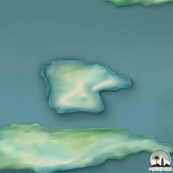
Size: 0.469 km²
Coastline: 3.1 km
Ocean: Atlantic Ocean
Sea: South Atlantic Ocean
Continent: Seven seas (open ocean)
Grass Island is a Tiny Island spanning 0.469 km² with a coastline of 3.1 km.
Archipel: –
Tectonic Plate: South America – A major plate covering the South American continent and part of the Atlantic Ocean, known for the Andes mountain range and significant seismic and volcanic activity.
The geographic heart of the island is pinpointed at these coordinates:
Latitude: -54.15850935 / Longitude: -36.66701221
Climate and weather of Grass Island
Climate Zone: Polar
Climate Details: Tundra
Temperature: Cold
Climate Characteristics: The tundra climate features long, extremely cold winters and short, cool summers. Vegetation is limited to mosses, lichens, and small shrubs due to the low temperatures and short growing seasons. Biodiversity is low, but some specialized species thrive.
Topography and nature of Grass Island
Timezone: UTC-02:00
Timezone places: Atlantic/South_Georgia
Max. Elevation: 7 m
Mean Elevation: 1 m
Vegetation: Snow and Ice Covered
Tree Coverage: 27%
The mean elevation is 1 m. The highest elevation on the island reaches approximately 7 meters above sea level. The island is characterized by Plains: Flat, low-lying lands characterized by a maximum elevation of up to 200 meters. On islands, plains are typically coastal lowlands or central flat areas.
Dominating Vegetation: Snow and Ice Covered
These areas are permanently or seasonally covered in snow and ice, with little to no vegetation, such as polar regions and high mountains. Grass Island has a tree cover of 27 %.
Vegetation: 1 vegetation zones – Minimal Diversity Island
These islands exhibit the most basic level of ecological diversity, often characterized by a single dominant vegetation type. This could be due to extreme environmental conditions, limited land area, or significant human impact. They represent unique ecosystems where specific species have adapted to thrive in these singular environments.
Infrastructure and Travelling to Grass Island
Does the island have a public airport? no.
There is no public and scheduled airport on Grass Island. The nearest airport is Port Stanley Airport, located 2361 km away.
Does the island have a major port? no.
There are no major ports on Grass Island. The closest major port is STROMNESS HARBOR, approximately 3 km away.
The mean population of Grass Island is per km². Grass Island is . The island belongs to United Kingdom.
Continuing your journey, South Georgia and the South Sandwich Islands is the next notable island, situated merely km away.
Plant Island - Full Song 3.3 (My Singing Monsters)
Plant Islands full song with Epic Wubbox! ⚡ All island songs: ...Plant Island - Full Song 3.3 (My Singing Monsters)
Plant Islands full song with Epic Wubbox! ⚡ All island songs: ...
Plant Islands full song with Epic Wubbox! ⚡ All island songs: ...
Plant Island - Full Song 5.2 (My Singing Monsters)
Plant Island's full song with its Colossal! 👁️ All island songs: ...
Plant Island's full song with its Colossal! 👁️ All island songs: ...
TAP MUN GRASS ISLAND HK | SHORT HIDDEN HIKE & AMAZING VIEWS (how to get there, views, highlights)
Tap Mun Grass Island is located in the northeastern part of the Hong ...
Tap Mun Grass Island is located in the northeastern part of the Hong Kong territory. It lies north of the Sai Kung East Country Park ...
ROUTE TO BALANCE ROCK || GRASS ISLAND || TAP MUN || HONG KONG EXPLORE
My Singing Monsters - Grass Island REMASTERED (Full Song)
A day trip to Grass Island in Sai Kung, Hong Kong
Grass Island is a sleepy fishing island in Sai Kung that can be reach ...
Grass Island is a sleepy fishing island in Sai Kung that can be reach by ferry from Wong Shek Pier. It is most famous for its ...
Tap Mun Island | Grass Island | Hong Kong
tapmun #grassisland #hongkong hiking time: About 1.5 hours Distance: ...
tapmun #grassisland #hongkong hiking time: About 1.5 hours Distance: Approximately 2.5 km Difficulty: Easy #塔門 #dji ...
#travel #camping #nature TAP MUN GRASS ISLAND HONG KONG 🇭🇰
Grass island II Tap Mun Camping II 塔門
A popular venue for camping, this tiny, scenic island features feral ...
A popular venue for camping, this tiny, scenic island features feral cattle & a temple complex.
Tap Mun 塔門 | Hong Kong's Most Breathtaking Island
Tap Mun, also known as Grass Island, is a perfect weekend getaway in ...
Tap Mun, also known as Grass Island, is a perfect weekend getaway in Sai Kung. The beautiful grassy hills and the unspoiled sea ...
Tap Mun Grass Island Drone Footage 4K
logronoflight #tapmungrassisland This plateau is covered in a meadow ...
logronoflight #tapmungrassisland This plateau is covered in a meadow which lends Tap Mun its English name, Grass Island.
Hong Kong 🇭🇰 Grass Island 🏝 Tap Mun. Camping 🏕 #campinghongkong #hongkong #grassisland #camping
HOW TO TAP MUN DAY TRIP | Grass Island Tap Mun Island Hike | Froi and Geri Hong Kong Vlog
And no, this is not New Zealand or Batanes but it's definitely a ...
And no, this is not New Zealand or Batanes but it's definitely a must-visit place in Hong Kong! This is the closest place to New ...
Plant Island Evolution - Full Song | My Singing Monsters
Plant Island Evolution: All Common Monsters and Rare Wubbox, Epic ...
Plant Island Evolution: All Common Monsters and Rare Wubbox, Epic Wubbox. I hope you like it and subscribe to my channel.
Grass island full song
Thank you from Moho 12 and @SampelMSM from doing yelmut Yooreek and to ...
Thank you from Moho 12 and @SampelMSM from doing yelmut Yooreek and to @cheezedibbles and The Rabero and Bamboo ...
TAP MUN GRASS ISLAND |how to get there?complete guide
view is fantastic at tap mun,camping ,beach,new zealand view ,all I ...
view is fantastic at tap mun,camping ,beach,new zealand view ,all I can say is awesome adventure !watch.
TAP MUN(GRASS ISLAND) CAMPING IN HONG KONG | A PERFECT GETAWAY (How to get there, views, highlights)
Autumn is a perfect weather to go camping. If you are looking for a ...
Autumn is a perfect weather to go camping. If you are looking for a place to go camping, Tap Mun (Grass Island) is one of most ...
Grass Island Drone Video
Birds Eye View of Grass Island and the Rock Barrier Being put in.
Birds Eye View of Grass Island and the Rock Barrier Being put in.
Tap mun.grass Island camping ground hongkong #explorehongkong
tap mun grass island hongkong||how to get to tap mun day trip
enjoy watching.
enjoy watching.
塔門 香港嘅小天堂 | GRASS ISLAND (Tap Mun) Little Paradise | HONG KONG
Grass Island or Tap Mun is an island in Hong Kong, located in the ...
Grass Island or Tap Mun is an island in Hong Kong, located in the northeastern part of the territory. A place that you must visit in ...
Grass Island/Pebble Beach Tap Mun/How to get there?/ Bebs Legaspi
grassisland #pebblebeach.
grassisland #pebblebeach.
Grass Island/Tap Mun Island, Hong Kong
Edna, Thelma, Rose, Shyla, Jane, Lea, Hanna and I explore Grass ...
Edna, Thelma, Rose, Shyla, Jane, Lea, Hanna and I explore Grass Island/Tap Mun Island in Hong Kong. Music: "So Lit" by Max ...
View from tap mun (grass island) #like #love #support #hknepal @IamCHOOSEN1
Hellow ,everyone Welcome back to new video.and for your information I ...
Hellow ,everyone Welcome back to new video.and for your information I haven't uploaded any videos recently sorry for that and ...
United Kingdom is classified as Developed region: G7: Group of Seven – Major advanced economies, including Canada, France, Germany, Italy, Japan, the United Kingdom, and the United States. The level of income is High income: OECD.
News – Latest Updates and Headlines from Grass Island
Stay informed with the most recent news and important headlines from Grass Island. Here’s a roundup of the latest developments.
Loading...
Please note: The data used here has been primarily extracted from satellite readings. Deviations from exact values may occur, particularly regarding the height of elevations and population density. Land area and coastline measurements refer to average values at mean high tide.