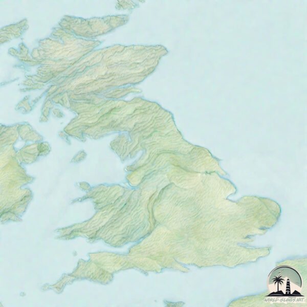
Great Britain
Welcome to Great Britain, a Temperate island in the Irish Sea and St. George’s Channel, part of the majestic Atlantic Ocean. This guide offers a comprehensive overview of what makes Great Britain unique – from its geography and climate to its population, infrastructure, and beyond. Dive into the details:
- Geography and Size: Explore the island’s size and location.
- Climate and Weather: Weather patterns and temperature.
- Topography and Nature: Uncover the natural wonders of the island.
- Infrastructure and Travelling: Insights on reaching, staying, and making the most of your visit.
- News and Headlines: Latest News.
Geography and size of Great Britain
Size: 218634 km²
Coastline: 12126 km
Ocean: Atlantic Ocean
Sea: Irish Sea and St. George’s Channel
Continent: Europe
Great Britain is a Colossal Island spanning 218634 km² with a coastline of 12126 km.
Archipel: British Isles – A group of islands off the northwest coast of mainland Europe, including Great Britain, Ireland, and over 6,000 smaller islands, known for their rich history and cultural diversity.
Tectonic Plate: Eurasia – One of the world’s largest tectonic plates, the Eurasian Plate covers a significant portion of Europe and Asia. It’s characterized by diverse geological features, including the Ural Mountains, the European Plain, and the Himalayas formed from its collision with the Indian Plate.
The geographic heart of the island is pinpointed at these coordinates:
Latitude: 53.94558492 / Longitude: -2.52307361
Climate and weather of Great Britain
Climate Zone: Temperate
Climate Details: Temperate Oceanic Climate
Temperature: Warm Summer
Climate Characteristics: Known for its moderate year-round temperatures with ample rainfall and no dry season. Warm summers are characteristic.
Topography and nature of Great Britain
Timezone: UTC±00:00
Timezone places: Europe/London
Max. Elevation: 1248 m
Mean Elevation: 170 m
Vegetation: Cultivated Land
Tree Coverage: 19%
The mean elevation is 170 m. The highest elevation on the island reaches approximately 1248 meters above sea level. The island is characterized by Plateau: Elevated flatlands rising sharply above the surrounding area, with a maximum elevation over 500 meters but a mean elevation less than 300 meters, forming unique highland areas on islands.
Dominating Vegetation: Cultivated Land
Areas dedicated to agricultural activities, growing crops like grains, vegetables, and fruits. These lands are usually human-modified landscapes. Great Britain has a tree cover of 19 %.
Vegetation: 15 vegetation zones – Exceptionally Diverse Island
Islands with more than ten vegetation zones are among the most ecologically rich and varied in the world. These islands are akin to miniature continents, boasting an incredible array of ecosystems. The sheer range of habitats, from high peaks to deep valleys, rainforests to deserts, creates a mosaic of life that is unparalleled. They are crucial for conservation and ecological studies.
Infrastructure and Travelling to Great Britain
Does the island have a public airport? yes.
Great Britain has a public and scheduled airport. The following airports are located on this island: Birmingham International Airport, Manchester Airport, Campbeltown Airport, Cardiff International Airport, Bristol Airport, Liverpool John Lennon Airport, London Luton Airport, Land’s End Airport, Bournemouth Airport, Southampton Airport, Cornwall Airport Newquay, London Gatwick Airport, London City Airport, London Heathrow Airport, Southend Airport, Blackpool International Airport, Humberside Airport, Leeds Bradford Airport, Newcastle Airport, Teesside International Airport, East Midlands Airport, Wick Airport, Aberdeen Dyce Airport, Inverness Airport, Glasgow International Airport, Edinburgh Airport, Glasgow Prestwick Airport, Dundee Airport, Norwich Airport, London Stansted Airport, Exeter International Airport.
Does the island have a major port? yes.
Great Britain is home to a major port. The following ports are situated on the island: LOSSIEMOUTH, PORTMAHOMACK HARBOR, HELMSDALE HARBOR, WICK, SCRABSTER HARBOR, ULLAPOOL, AULTBEA, GAIRLOCH, PLOCKTON, KYLE OF LOCHALSH, THAMESPORT, GRAVESEND, LONDON, COLCHESTER, IPSWICH, LOWESTOFT, GREAT YARMOUTH, KING’S LYNN, BOSTON, IMMINGHAM, KINGSTON UPON HULL, GOOLE, SCARBOROUGH, WHITBY, TEIGNMOUTH HARBOUR, BRIDPORT HARBOUR, SOUTHAMPTON, DARTMOUTH HARBOUR, MILFORD HAVEN, SWANSEA, NEATH, BARRY, SHARPNESS, AVONMOUTH, BRISTOL, BRIDGWATER, HAYLE, NEWLYN, FALMOUTH HARBOUR, CHARLESTOWN, PAR, CAERNARVON, BARROW IN FURNESS, FLEETWOOD, LIVERPOOL, MANCHESTER, MALLAIG, CORPACH, OBAN, CRINAN (CANAL), CAMPBELTOWN, MACDUFF, BLYTH, ARDRISHAIG, BOWLING, OLD KILPATRICK, ROTHESAY DOCK, RENFREW, GLASGOW, LARGS, ARDROSSAN, AYR, STRANRAER, WARKWORTH HARBOUR, BERWICK-UPON-TWEED, EYEMOUTH, DUNBAR, GRANGEMOUTH, DUNDEE, PERTH, MONTROSE, ABERDEEN, FRASERBURGH HARBOR, HARTLEPOOL, WISBECH, PENZANCE, MEVAGISSEY, LOCHALINE, PLYMOUTH, BRIXHAM HARBOUR, TORQUAY HARBOUR, FAWLEY MARINE TERMINAL, PORTSMOUTH HARBOUR, NEWHAVEN HARBOUR, RYE HARBOUR, RAMSGATE, ISLE OF GRAIN, FELIXSTOWE, FOLKESTONE HARBOUR, BIRD PORT, GARLSTON, HOWDENDYKE, LANCASTER, MOSTYN, NEW HOLLAND, TILBURY.
The mean population of Great Britain is 292 per km². Great Britain is Moderately Inhabited. The island belongs to United Kingdom.
The name of the island resonates across different cultures and languages. Here is how it is known around the world: Arabic: بريطانيا العظمى; German: Großbritannien; Spanish: Gran Bretaña; French: Grande-Bretagne; Portuguese: Grã-Bretanha; Russian: Великобритания; Chinese: 大不列顛島
Continuing your journey, Walney Island is the next notable island, situated merely km away.
Every British Constituent country, Territory, & Crown dependency, explained


United Kingdom is classified as Developed region: G7: Group of Seven – Major advanced economies, including Canada, France, Germany, Italy, Japan, the United Kingdom, and the United States. The level of income is High income: OECD.
News – Latest Updates and Headlines from Great Britain
Stay informed with the most recent news and important headlines from Great Britain. Here’s a roundup of the latest developments.
Social Media Posts about Great Britain
Please note: The data used here has been primarily extracted from satellite readings. Deviations from exact values may occur, particularly regarding the height of elevations and population density. Land area and coastline measurements refer to average values at mean high tide.