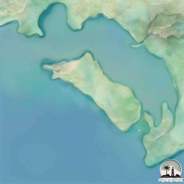
Welcome to Great Goat Island, a Tropical island in the Caribbean Sea, part of the majestic Atlantic Ocean. This guide offers a comprehensive overview of what makes Great Goat Island unique – from its geography and climate to its population, infrastructure, and beyond. Dive into the details:
Geography and size of Great Goat Island
Size: 5.354 km²
Coastline: 12.1 km
Ocean: Atlantic Ocean
Sea: Caribbean Sea
Continent: North America
Great Goat Island is a Small Island spanning 5.4 km² with a coastline of 12.1 km.
Archipel: Greater Antilles – A major island group in the Caribbean, including Cuba, Jamaica, Hispaniola, and Puerto Rico, known for their rich history and diverse cultures.
Tectonic Plate: Caribbean – Covering the Caribbean Sea and surrounding regions, this plate is bordered by the North American Plate and the South American Plate. Known for seismic activity, including earthquakes and volcanic eruptions, and features like the Puerto Rico Trench.
The geographic heart of the island is pinpointed at these coordinates:
Latitude: 17.87669601 / Longitude: -77.05913736
Climate and weather of Great Goat Island
Climate Zone: Tropical
Climate Details: Tropical Monsoon Climate
Temperature: Hot
Climate Characteristics: Characterized by heavy rainfall, high humidity, and uniformly high temperatures, but with a distinct short dry season. It features a seasonal reversal of prevailing wind directions.
Topography and nature of Great Goat Island
Timezone: UTC-05:00
Timezone places: America/New_York
Max. Elevation: 47 m
Mean Elevation: 19 m
Vegetation: Mangrove Forest
Tree Coverage: 97%
The mean elevation is 19 m. The highest elevation on the island reaches approximately 47 meters above sea level. The island is characterized by Plains: Flat, low-lying lands characterized by a maximum elevation of up to 200 meters. On islands, plains are typically coastal lowlands or central flat areas.
Dominating Vegetation: Mangrove Forest
Found in coastal areas and river deltas, these unique wetland ecosystems are adapted to saline conditions and are crucial for coastal protection and biodiversity. Great Goat Island has a tree cover of 97 %.
Vegetation: 6 vegetation zones – Very Highly Diverse Island
Islands in this range are ecological powerhouses, showcasing a wide array of vegetation zones. Each zone, from lush rainforests to arid scrublands, coastal mangroves to mountainous regions, contributes to a complex and interdependent ecosystem. These islands are often hotspots of biodiversity, supporting numerous species and intricate ecological processes.
Infrastructure and Travelling to Great Goat Island
Does the island have a public airport? no.
There is no public and scheduled airport on Great Goat Island. The nearest airport is Tinson Pen Airport, located 28 km away.
Does the island have a major port? no.
There are no major ports on Great Goat Island. The closest major port is PORT ESQUIVEL, approximately 6 km away.
The mean population of Great Goat Island is 459 per km². Great Goat Island is Moderately Inhabited. The island belongs to Jamaica.
The name of the island resonates across different cultures and languages. Here is how it is known around the world: Arabic: جامايكا; German: Jamaika; Spanish: Jamaica; French: Jamaïque; Portuguese: Jamaica; Russian: Ямайка; Chinese: 牙买加岛
Continuing your journey, Jamaica is the next notable island, situated merely km away.
GOAT ISLAND - FROM A SEAMAN'S POINT OF VIEW
Goat Island is currently a hot topic in Jamaica. Let's check out the opinion of a fisherman who has known the island for decades.GOAT ISLAND - FROM A SEAMAN'S POINT OF VIEW
Goat Island is currently a hot topic in Jamaica. Let's check out the ...
Goat Island is currently a hot topic in Jamaica. Let's check out the opinion of a fisherman who has known the island for decades.
Goat Island Jamaica
A day trip from Old Harbour Bay to Little Goat Island and a boat ride ...
A day trip from Old Harbour Bay to Little Goat Island and a boat ride around Great Goat Island.
Great Goat Island drone survey
I would like to thank @nature_org TNCJamaica for giving us drone ...
I would like to thank @nature_org TNCJamaica for giving us drone support for the Goat Island habitat assement ...
Spotlight on Goat Island (Season 2, Ep 6)
Spotlight is a weekly magazine programme that seeks to expose current ...
Spotlight is a weekly magazine programme that seeks to expose current affairs, arts, entertainment, culture and unusual, iconic or ...
Jamaica for Sale 2...? The Goat Island 'documentary'...
well one never crows but at least this battle was won... but we can't ...
well one never crows but at least this battle was won... but we can't sit on our laurels people! www.
Don't sell out Jamaica - Save Goat Islands
In August 2013, the Government of Jamaica (GOJ) revealed that China ...
In August 2013, the Government of Jamaica (GOJ) revealed that China Harbour Engineering Company (CHEC), had selected the ...
Midnight Oil - Best Of Both Worlds (triple j Live At The Wireless - Goat Island 1985)
Midnight Oil perform 'Best Of Both Worlds' live from Goat Island, ...
Midnight Oil perform 'Best Of Both Worlds' live from Goat Island, Sydney in 1985, presented by triple j's Live at the Wireless. 'Best ...
Goat Island History
Goatislands is not only about the plants & animals. It is also a place ...
Goatislands is not only about the plants & animals. It is also a place of rich culture. It was inahabitted by the Tainos, then the ...
Goat Island Jamaica Aerial Video
MODERN MEDIA SERVICES - 539-4344 Check out my New Kingston and Goat ...
Experience Jamaica - Goat island #jamaica #beach #island #shorts
Goat Islands, Old Harbour Bay, St Catherine "Little Goat Island along ...
Goat Islands, Old Harbour Bay, St Catherine "Little Goat Island along with Great Goat Island are the cays that make up the Goat ...
The search for Goat Island
The Gleaner went in search of Goat Island, the proposed site of the ...
The Gleaner went in search of Goat Island, the proposed site of the much touted logistics hub as part of the expansion of the ...
Don't Sell Out Jamaica - Save Goat Islands 2 - Extended PSA
In August 2013, the Government of Jamaica (GOJ) revealed that China ...
In August 2013, the Government of Jamaica (GOJ) revealed that China Harbour Engineering Company (CHEC), had selected the ...
Massive Snapper at Goat Island Marine Reserve
Kia Ora everyone. We had an awesome holiday hope you did also. Finally ...
Kia Ora everyone. We had an awesome holiday hope you did also. Finally made it out to one of the first Marine Reserves created ...
about that trip to Goat Island #travel #jamaica#tours#ja
fun day out to Goat Island onestop Cultural Tours in collab with ...
fun day out to Goat Island onestop Cultural Tours in collab with @cameronfamilytv @dreamislandtv1853 @NigelYahmantv.
Goat Island Jamaica "Isla de la Cabra"
Goat Island in Jamaica is a relatively small island. It covers an area ...
Goat Island in Jamaica is a relatively small island. It covers an area of approximately 0.24 square kilometers (about 24 hectares or ...
A walk through forest on Great Goat Island
The vegetation on #GreatGoatIsland is described as a #Drylimestone ...
The vegetation on #GreatGoatIsland is described as a #Drylimestone forest. Here is a typical walk through a field of agave.
Did you know that there was Military Base on Goat Island
Did you know that a USA #militarybase was built on #LittleGoatIsland ...
Did you know that a USA #militarybase was built on #LittleGoatIsland during the 2nd World War. Here is a plant growing on the ...
Meet the Locals: Goat island
Season 3, episode 6: Just north of Auckland you'll find New Zealand's ...
Season 3, episode 6: Just north of Auckland you'll find New Zealand's first marine reserve, Goat Island. Watch this video to learn ...
Kayaking in Jamaica-Goat Island
The Goat Islands, situated approximately 2.5 kilometers from Old ...
The Goat Islands, situated approximately 2.5 kilometers from Old Harbor in the Portland Bight, comprise two small islands, Big ...
Dee Mwango on Goat Island in Jamaica.
Great Youtubers linkup. @DeeMwango, @cameronfamilytv ...
Great Youtubers linkup. @DeeMwango, @cameronfamilytv ,@KINOLIFEINJAMAICA .@QUEEN SHEBA TV ,@divineesther ...
1st trip to Great Goat Island: COVID19
The first big trip for the team to #GreatGoatisland. As you can see we ...
The first big trip for the team to #GreatGoatisland. As you can see we all taking precautions as a result of #COVID19. We will soon ...
The Great Goat War in The Galapagos (Project Isabela)
The Great Goat War in The Galapagos (Project Isabela): A lot of people ...
The Great Goat War in The Galapagos (Project Isabela): A lot of people have heard about the Great Emu war. But have you ever ...
Valhalla Goat Island Mystery and the Coordinated Attack on Candace Owens
Discuss how the Goat Island Screen Saver may be planted to send comms ...
Discuss how the Goat Island Screen Saver may be planted to send comms through Geography with associated news stories also ...
Goat Islands in Jamaican waters
GoatIslands consist of Little Goat Island (~230 acres) and Great Goat ...
GoatIslands consist of Little Goat Island (~230 acres) and Great Goat Island (~630 acres). Both islands are less than 1mile from ...
Goat Island
Most accessible marine reserve in New Zealand.
Most accessible marine reserve in New Zealand.
Jamaica is classified as Developing region: Regions characterized by lower income levels, with economies in the process of industrialization and modernization. The level of income is Upper middle income.
News – Latest Updates and Headlines from Great Goat Island
Stay informed with the most recent news and important headlines from Great Goat Island. Here’s a roundup of the latest developments.
Loading...
Please note: The data used here has been primarily extracted from satellite readings. Deviations from exact values may occur, particularly regarding the height of elevations and population density. Land area and coastline measurements refer to average values at mean high tide.